You are here: Home > Network List > US - United States National Seismic Network Stations List
> Station TUC Tucson, Arizona, USA > Earthquake Result Viewer
TUC Tucson, Arizona, USA - Earthquake Result Viewer
| Earthquake location: |
Southeast Of Loyalty Islands |
| Earthquake latitude/longitude: |
-22.0/169.8 |
| Earthquake time(UTC): |
2003/12/27 (361) 16:00:59 GMT |
| Earthquake Depth: |
10 km |
| Earthquake Magnitude: |
6.1 MB, 7.1 MS, 7.3 MW, 7.2 MW |
| Earthquake Catalog/Contributor: |
WHDF/NEIC |
|
| Network: |
US United States National Seismic Network |
| Station: |
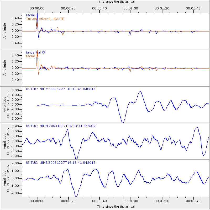
TUC Tucson, Arizona, USA |
| Lat/Lon: |
32.31 N/110.78 W |
| Elevation: |
906 m |
|
| Distance: |
93.1 deg |
| Az: |
56.481 deg |
| Baz: |
246.011 deg |
| Ray Param: |
0.041324235 |
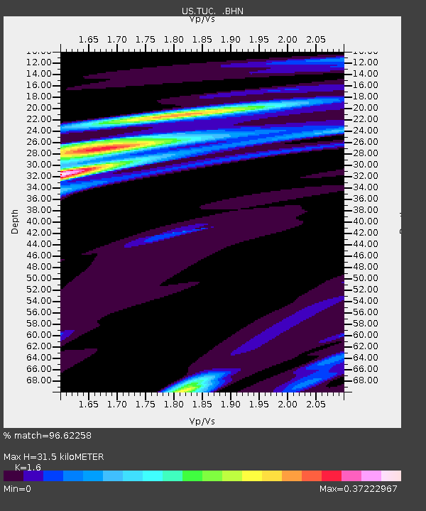
| Estimated Moho Depth: |
31.5 km |
| Estimated Crust Vp/Vs: |
1.60 |
| Assumed Crust Vp: |
6.276 km/s |
| Estimated Crust Vs: |
3.922 km/s |
| Estimated Crust Poisson's Ratio: |
0.18 |
|
| Radial Match: |
96.62258 % |
| Radial Bump: |
304 |
| Transverse Match: |
86.76301 % |
| Transverse Bump: |
400 |
| SOD ConfigId: |
110177 |
| Insert Time: |
2010-03-05 06:37:12.265 +0000 |
| GWidth: |
2.5 |
| Max Bumps: |
400 |
| Tol: |
0.001 |
|
Signal To Noise
| Channel | StoN | STA | LTA |
| US:TUC: :BHN:20031227T16:13:41.84801Z | 0.4761194 | 5.073345E-8 | 1.0655615E-7 |
| US:TUC: :BHE:20031227T16:13:41.84801Z | 1.3686811 | 1.4812969E-7 | 1.0822804E-7 |
| US:TUC: :BHZ:20031227T16:13:41.84801Z | 2.2601316 | 2.6160222E-7 | 1.1574646E-7 |
| Arrivals |
| Ps | 3.1 SECOND |
| PpPs | 13 SECOND |
| PsPs/PpSs | 16 SECOND |


