You are here: Home > Network List > US - United States National Seismic Network Stations List
> Station SSPA Standing Stone, Pennsylvania, USA > Earthquake Result Viewer
SSPA Standing Stone, Pennsylvania, USA - Earthquake Result Viewer
| Earthquake location: |
Northwest Of Kuril Islands |
| Earthquake latitude/longitude: |
47.8/146.2 |
| Earthquake time(UTC): |
2002/11/17 (321) 04:53:53 GMT |
| Earthquake Depth: |
459 km |
| Earthquake Magnitude: |
7.3 MW, 7.3 MW |
| Earthquake Catalog/Contributor: |
WHDF/NEIC |
|
| Network: |
US United States National Seismic Network |
| Station: |
SSPA Standing Stone, Pennsylvania, USA |
| Lat/Lon: |
40.64 N/77.89 W |
| Elevation: |
158 m |
|
| Distance: |
83.6 deg |
| Az: |
32.199 deg |
| Baz: |
331.845 deg |
| Ray Param: |
0.04477742 |
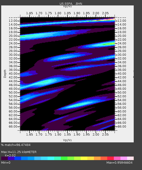
| Estimated Moho Depth: |
11.25 km |
| Estimated Crust Vp/Vs: |
2.02 |
| Assumed Crust Vp: |
6.121 km/s |
| Estimated Crust Vs: |
3.03 km/s |
| Estimated Crust Poisson's Ratio: |
0.34 |
|
| Radial Match: |
96.47484 % |
| Radial Bump: |
267 |
| Transverse Match: |
83.22042 % |
| Transverse Bump: |
400 |
| SOD ConfigId: |
4714 |
| Insert Time: |
2010-03-05 06:37:18.894 +0000 |
| GWidth: |
2.5 |
| Max Bumps: |
400 |
| Tol: |
0.001 |
|

Signal To Noise
| Channel | StoN | STA | LTA |
| US:SSPA: :BHN:20021117T05:05:01.495017Z | 15.168892 | 7.174697E-6 | 4.7298755E-7 |
| US:SSPA: :BHE:20021117T05:05:01.495017Z | 5.5337715 | 2.7719404E-6 | 5.009134E-7 |
| US:SSPA: :BHZ:20021117T05:05:01.495017Z | 29.499825 | 1.9771238E-5 | 6.7021546E-7 |
| Arrivals |
| Ps | 1.9 SECOND |
| PpPs | 5.4 SECOND |
| PsPs/PpSs | 7.4 SECOND |


