
Station US SSPA - Standing Stone, Pennsylvania, USA
Network: US - United States National Seismic Network
Nearby stations (2 deg radius)
| Station | Name | (Lat, Lon) | Start / End | Elevation |
| SSPA | Standing Stone, Pennsylvania, USA | (40.64, -77.89) | 1995-09-22 / 2499-01-01 | 158 m |
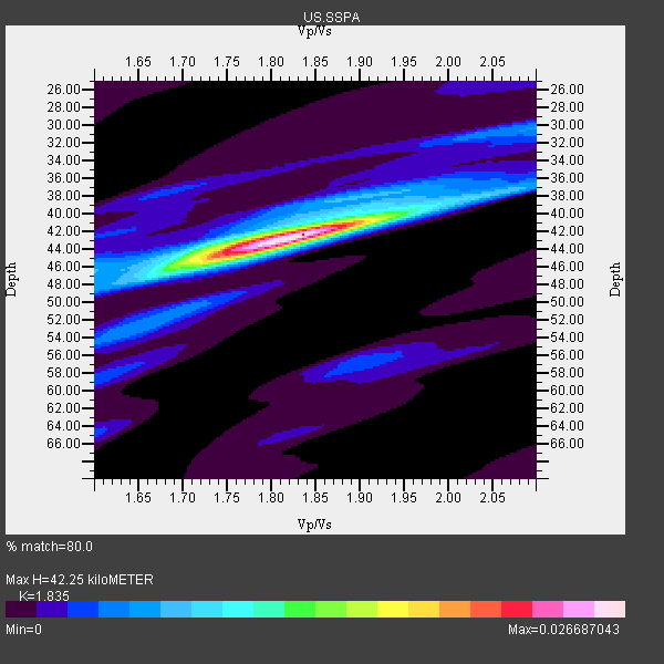
| Crust2 Type: | Q1,orogen/39km no ice, Appalachians, North Andes |
| Thickness Estimate: | 42 km |
| Thickness StdDev: | 0.5 km |
| Vp/Vs Estimate: | 1.84 |
| Vp/Vs StdDev: | 0.02 |
| Vs Estimate: | 3.335 km/s |
| Poisson's Ratio: | 0.29 |
| Peak Value: | 0.03 |
| Assumed Vp: | 6.121 km/s |
| Ps Weight: | 0.33333334 |
| PpPs Weight: | 0.33333334 |
| PsPs Weight: | 0.33333328 |
| Residual Complexity: | 0.472 |
| Nearby stations H: | 42 km +- 0.0 km |
| (2.0 deg) Vp/Vs: | 1.85 +- 0.01 |
15 with match > 90% ( 65.21739 %) and 23 with match > 80% ( 100.0 %) out of 23.
Download stack as xyz text file.
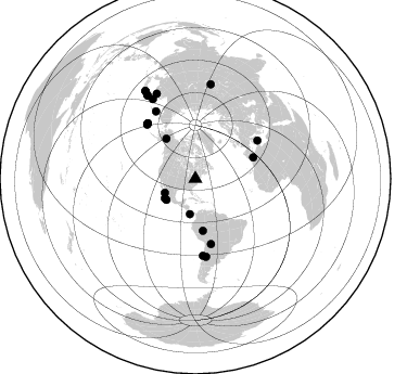
Azimuth Distribution of Events:
Prior Results for this Station
| Study | Thickness | Vp/Vs | Vp | Vs | Poissons Ratio | Extra |
| EARS | 42 km | 1.84 | 6.121 km/s | 3.335 km/s | 0.29 | |
| Crust2.0 | 39 km | 1.76 | 6.121 km/s | 3.485 km/s | 0.26 | Q1,orogen/39km no ice, Appalachians, North Andes |
| Global Maxima | 42 km | 1.84 | 6.121 km/s | 3.335 km/s | 0.29 | amp=0.026687043 |
| Local Maxima 1 | 45 km | 1.73 | 6.121 km/s | 3.543 km/s | 0.25 | amp=0.012712661 |
| Local Maxima 2 | 39 km | 1.97 | 6.121 km/s | 3.103 km/s | 0.33 | amp=0.006850775 |
| Local Maxima 3 | 30 km | 2.09 | 6.121 km/s | 2.925 km/s | 0.35 | amp=0.005138768 |
| Local Maxima 4 | 48 km | 1.60 | 6.121 km/s | 3.825 km/s | 0.18 | amp=0.003920537 |
| Predicted Arrivals for vertical incidence (zero ray parameter) | |
| Ps | 5.76 SECOND |
| PpPs | 19.57 SECOND |
| PsPs/PpSs | 25.33 SECOND |
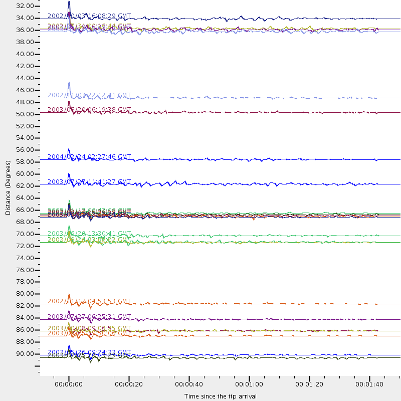
Events Processed for this Station
Download zip of receiver functions as SAC
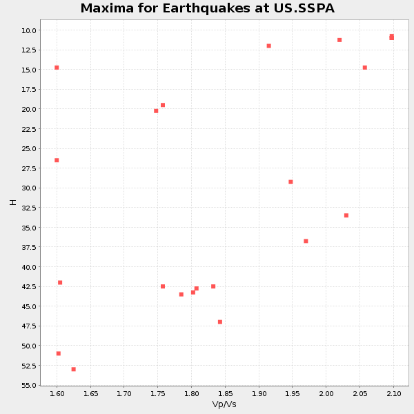
Plot maxima for each earthquake.
Events Used in the Stack
(23 events)| Radial Match | Distance | Baz | FERegion | Time | Lat/Lon | Depth | Magnitude |
| 98.91562 | 89.6 deg | 330.116 deg | Hokkaido, Japan Region | 2003/09/25 19:50:06 GMT | (41.8, 143.9) | 27 km | 6.9 MB, 8.1 MS, 8.3 MW, 8.1 MW |
| 98.039246 | 67.7 deg | 319.262 deg | Rat Islands, Aleutian Islands | 2003/06/23 12:12:34 GMT | (51.4, 176.8) | 20 km | 6.3 MB, 7.0 MS, 6.9 MW, 6.8 MW |
| 97.37076 | 71.1 deg | 174.306 deg | Near Coast Of Central Chile | 2003/06/20 13:30:41 GMT | (-30.6, -71.6) | 33 km | 6.4 MB, 6.8 MS, 6.8 MW, 6.7 MW |
| 97.07221 | 45.6 deg | 324.021 deg | Central Alaska | 2002/11/03 22:12:41 GMT | (63.5, -147.4) | 4.9 km | 7.0 MB, 8.5 MS, 7.9 MW |
| 97.03362 | 93.1 deg | 330.203 deg | Near East Coast Of Honshu, Japan | 2003/05/26 09:24:33 GMT | (38.8, 141.6) | 68 km | 6.7 MB, 7.0 MW, 7.0 MW |
| 96.79781 | 66.9 deg | 318.244 deg | Rat Islands, Aleutian Islands | 2003/11/17 06:43:06 GMT | (51.1, 178.6) | 33 km | 6.2 MB, 7.2 MS, 7.8 MW, 7.7 MW |
| 96.573044 | 72.4 deg | 329.613 deg | Kamchatka Peninsula, Russia | 2003/06/16 22:08:02 GMT | (55.5, 160.0) | 175 km | 6.3 MB, 6.9 MW, 6.9 MW |
| 96.53327 | 86.6 deg | 335.62 deg | Primor'ye, Russia | 2003/07/27 06:25:31 GMT | (47.2, 139.2) | 470 km | 6.3 MB, 6.8 MW, 6.8 MW |
| 96.47484 | 83.6 deg | 331.845 deg | Northwest Of Kuril Islands | 2002/11/17 04:53:53 GMT | (47.8, 146.2) | 459 km | 7.3 MW, 7.3 MW |
| 94.899086 | 48.3 deg | 171.806 deg | Western Brazil | 2003/06/20 06:19:38 GMT | (-7.6, -71.7) | 558 km | 6.4 MB, 7.1 MW, 7.0 MW |
| 94.1958 | 33.1 deg | 234.037 deg | Off Coast Of Jalisco, Mexico | 2003/05/19 16:27:10 GMT | (17.5, -105.5) | 10 km | 5.6 MB, 5.8 MS, 6.2 MW, 6.1 MW |
| 92.24671 | 93.7 deg | 330.387 deg | Eastern Honshu, Japan | 2003/07/25 22:13:29 GMT | (38.4, 141.0) | 6.0 km | 6.0 MB, 5.8 MS, 6.1 MW, 5.9 MW |
| 91.30523 | 72.2 deg | 172.215 deg | San Juan Province, Argentina | 2002/09/24 03:57:22 GMT | (-31.5, -69.2) | 120 km | 6.2 MB, 6.4 MW, 6.3 MW |
| 90.6781 | 88.6 deg | 330.12 deg | Hokkaido, Japan Region | 2003/10/08 09:06:55 GMT | (42.6, 144.6) | 32 km | 6.0 MB, 6.6 MS, 6.7 MW, 6.6 MW |
| 90.145004 | 32.9 deg | 188.98 deg | South Of Panama | 2002/07/31 00:16:44 GMT | (7.9, -82.8) | 10 km | 6.0 MB, 6.4 MS, 6.5 MW, 6.4 MW |
| 88.6069 | 31.0 deg | 245.505 deg | Gulf Of California | 2002/10/03 16:08:29 GMT | (23.3, -108.5) | 10 km | 5.4 MB, 6.2 MS, 6.5 MW, 6.4 MW |
| 86.30086 | 57.0 deg | 69.872 deg | Strait Of Gibraltar | 2004/02/24 02:27:46 GMT | (35.1, -4.0) | 0.0 km | 6.2 MB, 6.4 MS, 6.4 MW, 6.4 MW |
| 84.84231 | 67.5 deg | 319.302 deg | Rat Islands, Aleutian Islands | 2003/06/15 19:24:33 GMT | (51.6, 176.9) | 20 km | 6.0 MB, 6.4 MS, 6.5 MW, 6.5 MW |
| 84.559235 | 67.2 deg | 318.628 deg | Rat Islands, Aleutian Islands | 2003/03/17 16:36:17 GMT | (51.3, 178.0) | 33 km | 5.9 MB, 6.7 MS, 7.0 MW, 7.0 MW |
| 84.22562 | 67.4 deg | 58.327 deg | Sicily, Italy | 2002/09/06 01:21:28 GMT | (38.4, 13.7) | 5.0 km | 5.8 MB, 5.5 MS, 5.9 MW, 5.9 MW |
| 83.31184 | 61.6 deg | 166.415 deg | Southern Bolivia | 2003/07/27 11:41:27 GMT | (-20.1, -65.2) | 345 km | 5.9 MB, 6.0 MW, 6.0 MW |
| 83.18679 | 88.7 deg | 9.191 deg | Southwestern Siberia, Russia | 2003/10/01 01:03:25 GMT | (50.2, 87.7) | 10 km | 6.3 MB, 7.1 MS, 6.7 MW, 6.7 MW |
| 80.84655 | 33.4 deg | 237.348 deg | Off Coast Of Jalisco, Mexico | 2003/07/17 19:57:13 GMT | (18.5, -107.1) | 10 km | 4.9 MB, 5.3 MS, 6.0 MW, 5.9 MW |
Losers
(0 events)| Radial Match | Distance | Baz | FERegion | Time | Lat/Lon | Depth | Magnitude | Reason |
