You are here: Home > Network List > US - United States National Seismic Network Stations List
> Station SSPA Standing Stone, Pennsylvania, USA > Earthquake Result Viewer
SSPA Standing Stone, Pennsylvania, USA - Earthquake Result Viewer

| Earthquake location: |
Gulf Of California |
| Earthquake latitude/longitude: |
23.3/-108.5 |
| Earthquake time(UTC): |
2002/10/03 (276) 16:08:29 GMT |
| Earthquake Depth: |
10 km |
| Earthquake Magnitude: |
5.4 MB, 6.2 MS, 6.5 MW, 6.4 MW |
| Earthquake Catalog/Contributor: |
WHDF/NEIC |
|
| Network: |
US United States National Seismic Network |
| Station: |
SSPA Standing Stone, Pennsylvania, USA |
| Lat/Lon: |
40.64 N/77.89 W |
| Elevation: |
158 m |
|
| Distance: |
31.0 deg |
| Az: |
48.883 deg |
| Baz: |
245.505 deg |
| Ray Param: |
0.07918773 |
| Estimated Moho Depth: |
53.0 km |
| Estimated Crust Vp/Vs: |
1.62 |
| Assumed Crust Vp: |
6.121 km/s |
| Estimated Crust Vs: |
3.766 km/s |
| Estimated Crust Poisson's Ratio: |
0.20 |
|
| Radial Match: |
88.6069 % |
| Radial Bump: |
271 |
| Transverse Match: |
72.18109 % |
| Transverse Bump: |
400 |
| SOD ConfigId: |
110177 |
| Insert Time: |
2010-03-05 06:37:24.994 +0000 |
| GWidth: |
2.5 |
| Max Bumps: |
400 |
| Tol: |
0.001 |
|
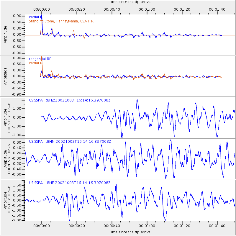
Signal To Noise
| Channel | StoN | STA | LTA |
| US:SSPA: :BHN:20021003T16:14:16.397008Z | 0.60363555 | 1.062489E-7 | 1.7601498E-7 |
| US:SSPA: :BHE:20021003T16:14:16.397008Z | 1.8000344 | 2.1451021E-7 | 1.1917007E-7 |
| US:SSPA: :BHZ:20021003T16:14:16.397008Z | 1.9172492 | 3.0710515E-7 | 1.6018008E-7 |
| Arrivals |
| Ps | 5.9 SECOND |
| PpPs | 21 SECOND |
| PsPs/PpSs | 27 SECOND |


