COR Corvallis, Oregon, USA - Earthquake Result Viewer
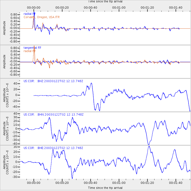
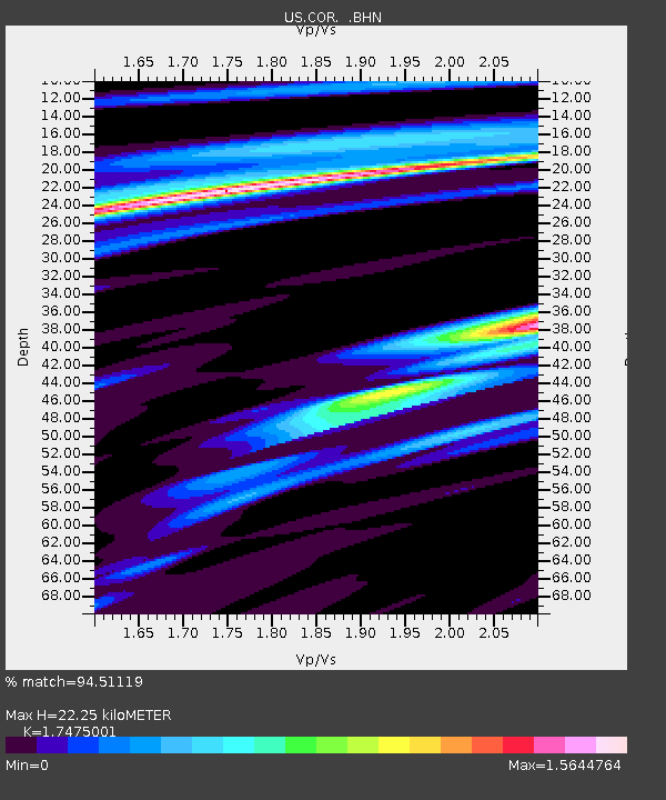
Earthquake location: Near Coast Of Jalisco, Mexico
Earthquake latitude/longitude: 18.8/-104.1
Earthquake time(UTC): 2003/01/22 (022) 02:06:34 GMT
Earthquake Depth: 24 km
Earthquake Magnitude: 6.5 MB, 7.6 MS, 7.6 MW, 7.4 MW
Earthquake Catalog/Contributor: WHDF/NEIC
Network: US United States National Seismic Network
Station: COR Corvallis, Oregon, USA
Lat/Lon: 44.59 N/123.30 W
Elevation: 121 m
Distance: 30.3 deg
Az: 332.27 deg
Baz: 141.904 deg
Ray Param: 0.07934196
Estimated Moho Depth: 22.25 km
Estimated Crust Vp/Vs: 1.75
Assumed Crust Vp: 6.566 km/s
Estimated Crust Vs: 3.757 km/s
Estimated Crust Poisson's Ratio: 0.26
Radial Match: 94.51119 %
Radial Bump: 368
Transverse Match: 74.85466 %
Transverse Bump: 400
SOD ConfigId: 110177
Insert Time: 2010-03-05 06:38:12.917 +0000
GWidth: 2.5
Max Bumps: 400
Tol: 0.001

Signal To Noise

ChannelStoNSTALTA
US:COR: :BHN:20030122T02:12:13.748Z1.75557721.9182798E-61.0926776E-6
US:COR: :BHE:20030122T02:12:13.748Z1.39181461.4583794E-61.0478259E-6
US:COR: :BHZ:20030122T02:12:13.748Z5.65205964.2778747E-67.568701E-7
Arrivals
Ps2.8 SECOND
PpPs8.5 SECOND
PsPs/PpSs11 SECOND