
Station US COR - Corvallis, Oregon, USA
Network: US - United States National Seismic Network
Nearby stations (2 deg radius)
| Station | Name | (Lat, Lon) | Start / End | Elevation |
| COR | Corvallis, Oregon, USA | (44.59, -123.30) | 1993-02-10 / 2499-01-01 | 121 m |
| Crust2 Type: | L8,thin continental arc, Cordilleras, 0.5 km seds. |
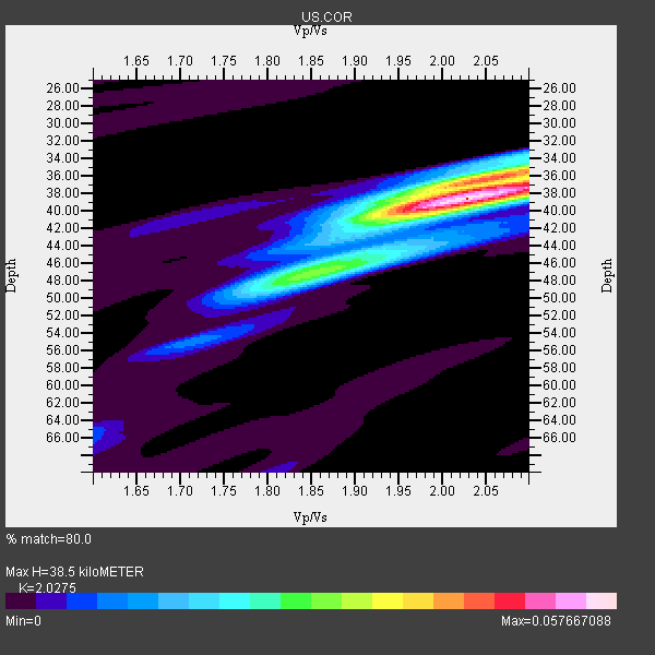
| Thickness Estimate: | 38 km |
| Thickness StdDev: | 0.9 km |
| Vp/Vs Estimate: | 2.03 |
| Vp/Vs StdDev: | 0.03 |
| Vs Estimate: | 3.239 km/s |
| Poisson's Ratio: | 0.34 |
| Peak Value: | 0.06 |
| Assumed Vp: | 6.566 km/s |
| Ps Weight: | 0.33333334 |
| PpPs Weight: | 0.33333334 |
| PsPs Weight: | 0.33333328 |
| Residual Complexity: | 0.520 |
| Nearby stations H: | 38 km +- 0.0 km |
| (2.0 deg) Vp/Vs: | 2.03 +- 0.00 |
9 with match > 90% ( 56.25 %) and 16 with match > 80% ( 100.0 %) out of 16.
Download stack as xyz text file.
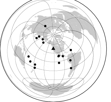
Azimuth Distribution of Events:
Prior Results for this Station
| Study | Thickness | Vp/Vs | Vp | Vs | Poissons Ratio | Extra |
| EARS | 38 km | 2.03 | 6.566 km/s | 3.239 km/s | 0.34 | |
| Crust2.0 | 34 km | 1.77 | 6.566 km/s | 3.707 km/s | 0.27 | L8,thin continental arc, Cordilleras, 0.5 km seds. |
| Global Maxima | 38 km | 2.03 | 6.566 km/s | 3.239 km/s | 0.34 | amp=0.057667088 |
| Local Maxima 1 | 36 km | 2.04 | 6.566 km/s | 3.219 km/s | 0.34 | amp=0.035591673 |
| Local Maxima 2 | 48 km | 1.83 | 6.566 km/s | 3.593 km/s | 0.29 | amp=0.018307334 |
| Local Maxima 3 | 44 km | 1.96 | 6.566 km/s | 3.346 km/s | 0.32 | amp=0.012443854 |
| Local Maxima 4 | 34 km | 2.06 | 6.566 km/s | 3.191 km/s | 0.35 | amp=0.010415631 |
| Predicted Arrivals for vertical incidence (zero ray parameter) | |
| Ps | 6.02 SECOND |
| PpPs | 17.75 SECOND |
| PsPs/PpSs | 23.78 SECOND |
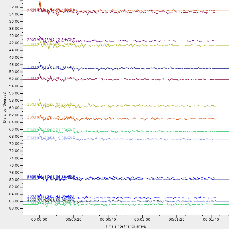
Events Processed for this Station
Download zip of receiver functions as SAC
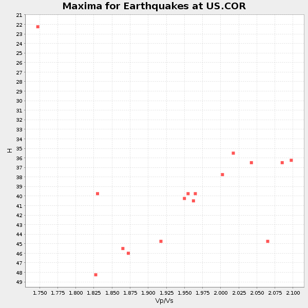
Plot maxima for each earthquake.
Events Used in the Stack
(16 events)| Radial Match | Distance | Baz | FERegion | Time | Lat/Lon | Depth | Magnitude |
| 95.3708 | 67.2 deg | 302.487 deg | Near East Coast Of Honshu, Japan | 2003/05/26 09:24:33 GMT | (38.8, 141.6) | 68 km | 6.7 MB, 7.0 MW, 7.0 MW |
| 95.35775 | 88.4 deg | 137.425 deg | Near Coast Of Central Chile | 2003/06/20 13:30:41 GMT | (-30.6, -71.6) | 33 km | 6.4 MB, 6.8 MS, 6.8 MW, 6.7 MW |
| 94.51119 | 30.3 deg | 141.904 deg | Near Coast Of Jalisco, Mexico | 2003/01/22 02:06:34 GMT | (18.8, -104.1) | 24 km | 6.5 MB, 7.6 MS, 7.6 MW, 7.4 MW |
| 93.88921 | 87.5 deg | 252.731 deg | Solomon Islands | 2003/01/20 08:43:06 GMT | (-10.5, 160.8) | 33 km | 6.7 MB, 7.8 MS, 7.3 MW, 7.2 MW |
| 93.5685 | 69.6 deg | 124.052 deg | Western Brazil | 2003/06/20 06:19:38 GMT | (-7.6, -71.7) | 558 km | 6.4 MB, 7.1 MW, 7.0 MW |
| 93.16403 | 59.4 deg | 94.115 deg | North Atlantic Ocean | 2003/05/14 06:03:35 GMT | (18.3, -58.6) | 42 km | 6.5 MB, 6.5 MS, 6.6 MW, 6.6 MW |
| 92.705666 | 48.0 deg | 311.844 deg | Kamchatka Peninsula, Russia | 2003/06/16 22:08:02 GMT | (55.5, 160.0) | 175 km | 6.3 MB, 6.9 MW, 6.9 MW |
| 91.395485 | 81.8 deg | 340.454 deg | Southwestern Siberia, Russia | 2003/10/01 01:03:25 GMT | (50.2, 87.7) | 10 km | 6.3 MB, 7.1 MS, 6.7 MW, 6.7 MW |
| 90.3361 | 63.4 deg | 310.799 deg | Primor'ye, Russia | 2003/07/27 06:25:31 GMT | (47.2, 139.2) | 470 km | 6.3 MB, 6.8 MW, 6.8 MW |
| 89.67091 | 81.4 deg | 229.202 deg | Fiji Islands Region | 2003/07/27 02:04:11 GMT | (-21.1, -176.6) | 213 km | 5.9 MB, 6.6 MW, 6.6 MW |
| 89.04489 | 51.4 deg | 157.758 deg | Central East Pacific Rise | 2003/09/06 02:08:13 GMT | (-4.6, -106.0) | 10 km | 5.4 MB, 5.8 MS, 6.1 MW, 6.0 MW |
| 87.699905 | 39.7 deg | 301.951 deg | Rat Islands, Aleutian Islands | 2003/06/23 12:12:34 GMT | (51.4, 176.8) | 20 km | 6.3 MB, 7.0 MS, 6.9 MW, 6.8 MW |
| 87.39866 | 41.0 deg | 127.841 deg | Guatemala | 2003/08/25 06:28:35 GMT | (14.0, -91.1) | 100 km | 5.4 MB, 5.9 MW, 5.9 MW |
| 87.1136 | 88.5 deg | 241.044 deg | Vanuatu Islands | 2003/11/06 10:38:04 GMT | (-19.3, 168.9) | 114 km | 6.0 MB, 6.6 MW, 6.6 MW |
| 86.59465 | 30.8 deg | 145.261 deg | Off Coast Of Jalisco, Mexico | 2003/05/19 16:27:10 GMT | (17.5, -105.5) | 10 km | 5.6 MB, 5.8 MS, 6.2 MW, 6.1 MW |
| 86.28562 | 89.5 deg | 224.394 deg | Kermadec Islands, New Zealand | 2003/09/30 14:08:37 GMT | (-30.4, -177.4) | 10 km | 5.8 MB, 6.5 MS, 6.4 MW, 6.4 MW |
Losers
(0 events)| Radial Match | Distance | Baz | FERegion | Time | Lat/Lon | Depth | Magnitude | Reason |
