You are here: Home > Network List > US - United States National Seismic Network Stations List
> Station COR Corvallis, Oregon, USA > Earthquake Result Viewer
COR Corvallis, Oregon, USA - Earthquake Result Viewer
| Earthquake location: |
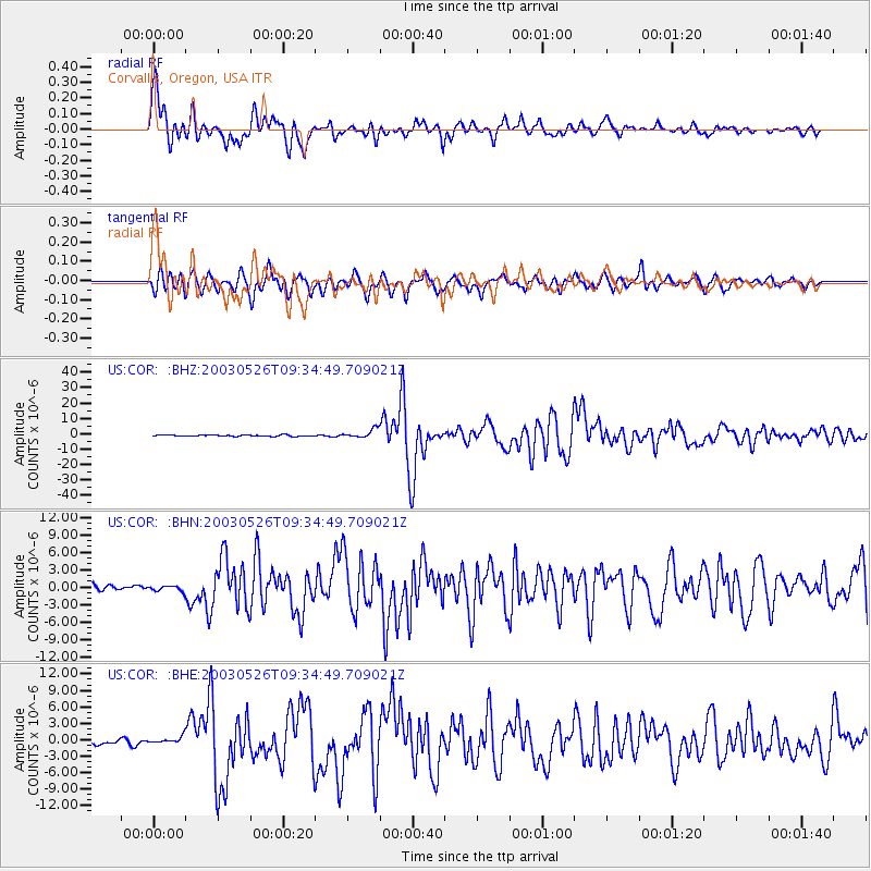
Near East Coast Of Honshu, Japan |
| Earthquake latitude/longitude: |
38.8/141.6 |
| Earthquake time(UTC): |
2003/05/26 (146) 09:24:33 GMT |
| Earthquake Depth: |
68 km |
| Earthquake Magnitude: |
6.7 MB, 7.0 MW, 7.0 MW |
| Earthquake Catalog/Contributor: |
WHDF/NEIC |
|
| Network: |
US United States National Seismic Network |
| Station: |
COR Corvallis, Oregon, USA |
| Lat/Lon: |
44.59 N/123.30 W |
| Elevation: |
121 m |
|
| Distance: |
67.2 deg |
| Az: |
50.524 deg |
| Baz: |
302.487 deg |
| Ray Param: |
0.056939594 |
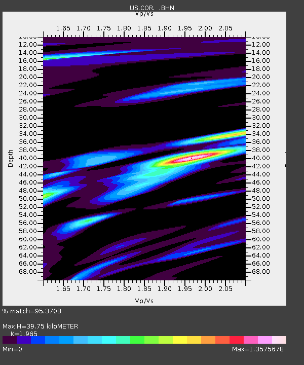
| Estimated Moho Depth: |
39.75 km |
| Estimated Crust Vp/Vs: |
1.97 |
| Assumed Crust Vp: |
6.566 km/s |
| Estimated Crust Vs: |
3.342 km/s |
| Estimated Crust Poisson's Ratio: |
0.33 |
|
| Radial Match: |
95.3708 % |
| Radial Bump: |
400 |
| Transverse Match: |
88.77904 % |
| Transverse Bump: |
400 |
| SOD ConfigId: |
110177 |
| Insert Time: |
2010-03-05 06:38:17.574 +0000 |
| GWidth: |
2.5 |
| Max Bumps: |
400 |
| Tol: |
0.001 |
|
Signal To Noise
| Channel | StoN | STA | LTA |
| US:COR: :BHN:20030526T09:34:49.709021Z | 1.1621293 | 4.935738E-7 | 4.2471504E-7 |
| US:COR: :BHE:20030526T09:34:49.709021Z | 1.3879207 | 6.69342E-7 | 4.822624E-7 |
| US:COR: :BHZ:20030526T09:34:49.709021Z | 6.413684 | 2.812185E-6 | 4.384664E-7 |
| Arrivals |
| Ps | 6.1 SECOND |
| PpPs | 17 SECOND |
| PsPs/PpSs | 23 SECOND |


