You are here: Home > Network List > US - United States National Seismic Network Stations List
> Station COR Corvallis, Oregon, USA > Earthquake Result Viewer
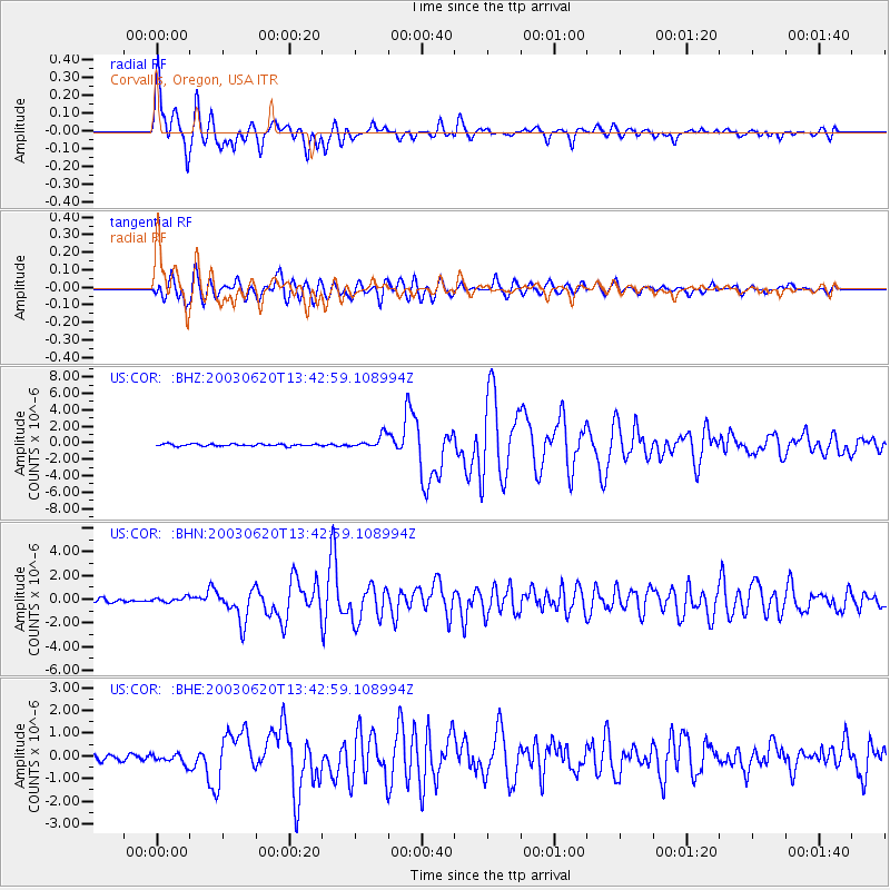
COR Corvallis, Oregon, USA - Earthquake Result Viewer
| Earthquake location: |
Near Coast Of Central Chile |
| Earthquake latitude/longitude: |
-30.6/-71.6 |
| Earthquake time(UTC): |
2003/06/20 (171) 13:30:41 GMT |
| Earthquake Depth: |
33 km |
| Earthquake Magnitude: |
6.4 MB, 6.8 MS, 6.8 MW, 6.7 MW |
| Earthquake Catalog/Contributor: |
WHDF/NEIC |
|
| Network: |
US United States National Seismic Network |
| Station: |
COR Corvallis, Oregon, USA |
| Lat/Lon: |
44.59 N/123.30 W |
| Elevation: |
121 m |
|
| Distance: |
88.4 deg |
| Az: |
325.894 deg |
| Baz: |
137.425 deg |
| Ray Param: |
0.042562183 |
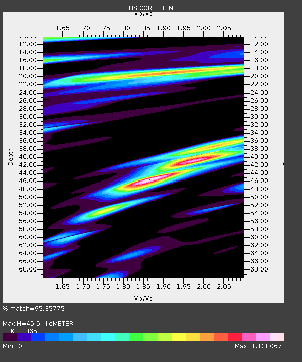
| Estimated Moho Depth: |
45.5 km |
| Estimated Crust Vp/Vs: |
1.87 |
| Assumed Crust Vp: |
6.566 km/s |
| Estimated Crust Vs: |
3.521 km/s |
| Estimated Crust Poisson's Ratio: |
0.30 |
|
| Radial Match: |
95.35775 % |
| Radial Bump: |
400 |
| Transverse Match: |
85.23604 % |
| Transverse Bump: |
400 |
| SOD ConfigId: |
110177 |
| Insert Time: |
2010-03-05 06:38:21.512 +0000 |
| GWidth: |
2.5 |
| Max Bumps: |
400 |
| Tol: |
0.001 |
|
Signal To Noise
| Channel | StoN | STA | LTA |
| US:COR: :BHN:20030620T13:42:59.108994Z | 1.080185 | 2.1403582E-7 | 1.9814736E-7 |
| US:COR: :BHE:20030620T13:42:59.108994Z | 1.6241995 | 2.2051533E-7 | 1.3576863E-7 |
| US:COR: :BHZ:20030620T13:42:59.108994Z | 6.033311 | 8.011344E-7 | 1.327852E-7 |
| Arrivals |
| Ps | 6.1 SECOND |
| PpPs | 19 SECOND |
| PsPs/PpSs | 26 SECOND |


