You are here: Home > Network List > US - United States National Seismic Network Stations List
> Station COR Corvallis, Oregon, USA > Earthquake Result Viewer
COR Corvallis, Oregon, USA - Earthquake Result Viewer
| Earthquake location: |
Guatemala |
| Earthquake latitude/longitude: |
14.0/-91.1 |
| Earthquake time(UTC): |
2003/08/25 (237) 06:28:35 GMT |
| Earthquake Depth: |
100 km |
| Earthquake Magnitude: |
5.4 MB, 5.9 MW, 5.9 MW |
| Earthquake Catalog/Contributor: |
WHDF/NEIC |
|
| Network: |
US United States National Seismic Network |
| Station: |
COR Corvallis, Oregon, USA |
| Lat/Lon: |
44.59 N/123.30 W |
| Elevation: |
121 m |
|
| Distance: |
41.0 deg |
| Az: |
324.449 deg |
| Baz: |
127.841 deg |
| Ray Param: |
0.07374182 |
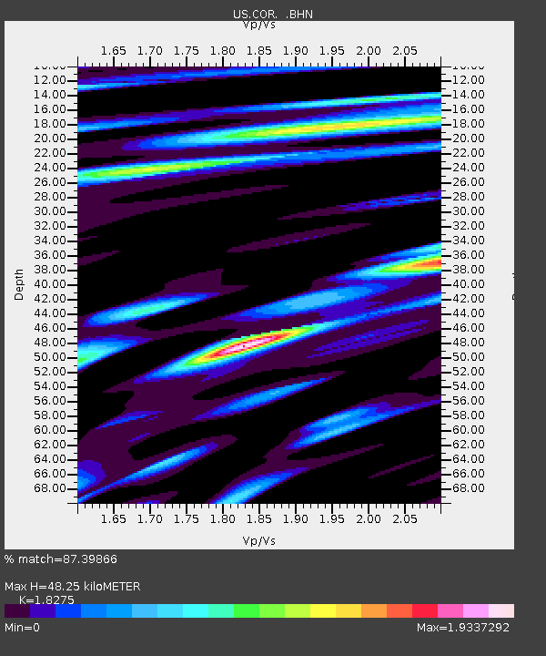
| Estimated Moho Depth: |
48.25 km |
| Estimated Crust Vp/Vs: |
1.83 |
| Assumed Crust Vp: |
6.566 km/s |
| Estimated Crust Vs: |
3.593 km/s |
| Estimated Crust Poisson's Ratio: |
0.29 |
|
| Radial Match: |
87.39866 % |
| Radial Bump: |
400 |
| Transverse Match: |
78.46683 % |
| Transverse Bump: |
400 |
| SOD ConfigId: |
110177 |
| Insert Time: |
2010-03-05 06:38:26.671 +0000 |
| GWidth: |
2.5 |
| Max Bumps: |
400 |
| Tol: |
0.001 |
|
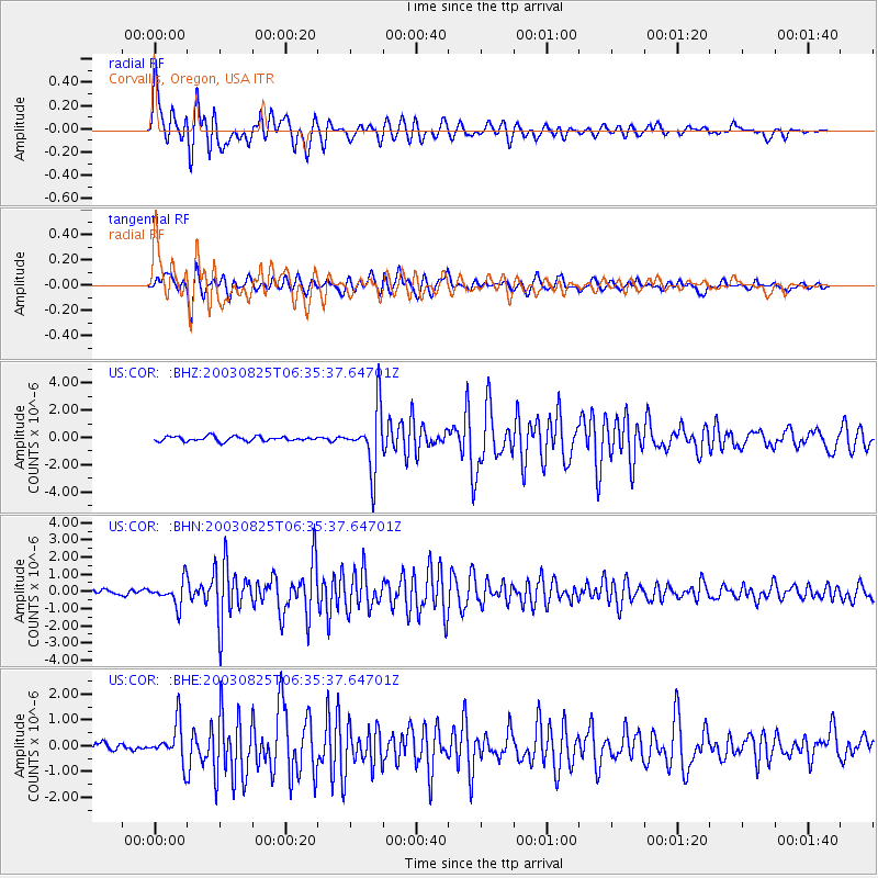
Signal To Noise
| Channel | StoN | STA | LTA |
| US:COR: :BHN:20030825T06:35:37.64701Z | 4.1209006 | 7.153848E-7 | 1.7359913E-7 |
| US:COR: :BHE:20030825T06:35:37.64701Z | 4.4635024 | 7.647718E-7 | 1.7133895E-7 |
| US:COR: :BHZ:20030825T06:35:37.64701Z | 12.820363 | 2.1958476E-6 | 1.712781E-7 |
| Arrivals |
| Ps | 6.5 SECOND |
| PpPs | 19 SECOND |
| PsPs/PpSs | 26 SECOND |


