You are here: Home > Network List > US - United States National Seismic Network Stations List
> Station COR Corvallis, Oregon, USA > Earthquake Result Viewer
COR Corvallis, Oregon, USA - Earthquake Result Viewer
| Earthquake location: |
Vanuatu Islands |
| Earthquake latitude/longitude: |
-19.3/168.9 |
| Earthquake time(UTC): |
2003/11/06 (310) 10:38:04 GMT |
| Earthquake Depth: |
114 km |
| Earthquake Magnitude: |
6.0 MB, 6.6 MW, 6.6 MW |
| Earthquake Catalog/Contributor: |
WHDF/NEIC |
|
| Network: |
US United States National Seismic Network |
| Station: |
COR Corvallis, Oregon, USA |
| Lat/Lon: |
44.59 N/123.30 W |
| Elevation: |
121 m |
|
| Distance: |
88.5 deg |
| Az: |
41.439 deg |
| Baz: |
241.044 deg |
| Ray Param: |
0.04227374 |
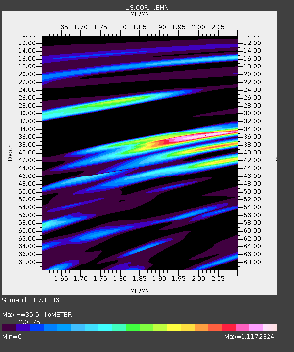
| Estimated Moho Depth: |
35.5 km |
| Estimated Crust Vp/Vs: |
2.02 |
| Assumed Crust Vp: |
6.566 km/s |
| Estimated Crust Vs: |
3.255 km/s |
| Estimated Crust Poisson's Ratio: |
0.34 |
|
| Radial Match: |
87.1136 % |
| Radial Bump: |
400 |
| Transverse Match: |
86.42708 % |
| Transverse Bump: |
400 |
| SOD ConfigId: |
110177 |
| Insert Time: |
2010-03-05 06:38:33.665 +0000 |
| GWidth: |
2.5 |
| Max Bumps: |
400 |
| Tol: |
0.001 |
|
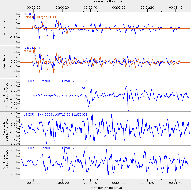
Signal To Noise
| Channel | StoN | STA | LTA |
| US:COR: :BHN:20031106T10:50:12.93502Z | 1.2987975 | 4.2660488E-7 | 3.2846145E-7 |
| US:COR: :BHE:20031106T10:50:12.93502Z | 1.4487189 | 4.532365E-7 | 3.128533E-7 |
| US:COR: :BHZ:20031106T10:50:12.93502Z | 5.2378063 | 1.3457624E-6 | 2.5693245E-7 |
| Arrivals |
| Ps | 5.6 SECOND |
| PpPs | 16 SECOND |
| PsPs/PpSs | 22 SECOND |


