You are here: Home > Network List > TA - USArray Transportable Network (new EarthScope stations) Stations List
> Station L02F Cave Junction, OR, USA > Earthquake Result Viewer
L02F Cave Junction, OR, USA - Earthquake Result Viewer
| Earthquake location: |
Komandorskiye Ostrova Region |
| Earthquake latitude/longitude: |
54.3/168.6 |
| Earthquake time(UTC): |
2016/09/05 (249) 22:54:04 GMT |
| Earthquake Depth: |
10 km |
| Earthquake Magnitude: |
5.7 MB |
| Earthquake Catalog/Contributor: |
NEIC PDE/NEIC COMCAT |
|
| Network: |
TA USArray Transportable Network (new EarthScope stations) |
| Station: |
L02F Cave Junction, OR, USA |
| Lat/Lon: |
42.12 N/123.57 W |
| Elevation: |
440 m |
|
| Distance: |
45.1 deg |
| Az: |
76.637 deg |
| Baz: |
310.034 deg |
| Ray Param: |
0.071510114 |
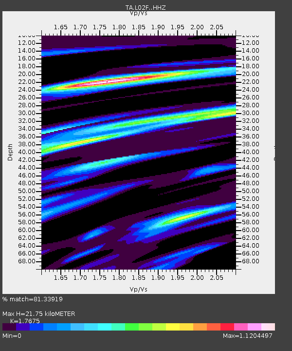
| Estimated Moho Depth: |
21.75 km |
| Estimated Crust Vp/Vs: |
1.77 |
| Assumed Crust Vp: |
6.522 km/s |
| Estimated Crust Vs: |
3.69 km/s |
| Estimated Crust Poisson's Ratio: |
0.26 |
|
| Radial Match: |
81.33919 % |
| Radial Bump: |
370 |
| Transverse Match: |
53.35514 % |
| Transverse Bump: |
400 |
| SOD ConfigId: |
11737051 |
| Insert Time: |
2019-04-25 11:16:05.591 +0000 |
| GWidth: |
2.5 |
| Max Bumps: |
400 |
| Tol: |
0.001 |
|
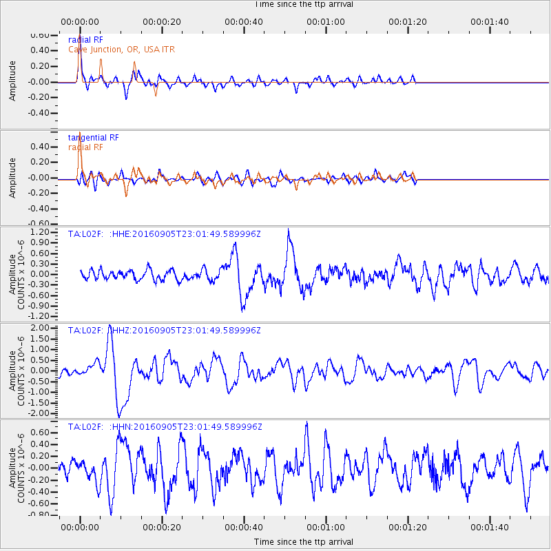
Signal To Noise
| Channel | StoN | STA | LTA |
| TA:L02F: :HHZ:20160905T23:01:49.589996Z | 2.749012 | 3.1910542E-7 | 1.16080045E-7 |
| TA:L02F: :HHN:20160905T23:01:49.589996Z | 1.5623564 | 1.8717836E-7 | 1.1980516E-7 |
| TA:L02F: :HHE:20160905T23:01:49.589996Z | 1.322297 | 1.7805971E-7 | 1.3465939E-7 |
| Arrivals |
| Ps | 2.7 SECOND |
| PpPs | 8.6 SECOND |
| PsPs/PpSs | 11 SECOND |


