You are here: Home > Network List > US - United States National Seismic Network Stations List
> Station ISA Isabella, Kern County, California, USA > Earthquake Result Viewer
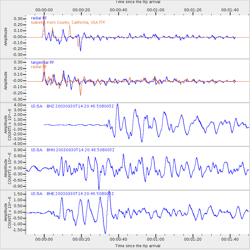
ISA Isabella, Kern County, California, USA - Earthquake Result Viewer
| Earthquake location: |
Kermadec Islands, New Zealand |
| Earthquake latitude/longitude: |
-30.4/-177.4 |
| Earthquake time(UTC): |
2003/09/30 (273) 14:08:37 GMT |
| Earthquake Depth: |
10 km |
| Earthquake Magnitude: |
5.8 MB, 6.5 MS, 6.4 MW, 6.4 MW |
| Earthquake Catalog/Contributor: |
WHDF/NEIC |
|
| Network: |
US United States National Seismic Network |
| Station: |
ISA Isabella, Kern County, California, USA |
| Lat/Lon: |
35.66 N/118.47 W |
| Elevation: |
873 m |
|
| Distance: |
86.0 deg |
| Az: |
44.361 deg |
| Baz: |
227.864 deg |
| Ray Param: |
0.04439101 |
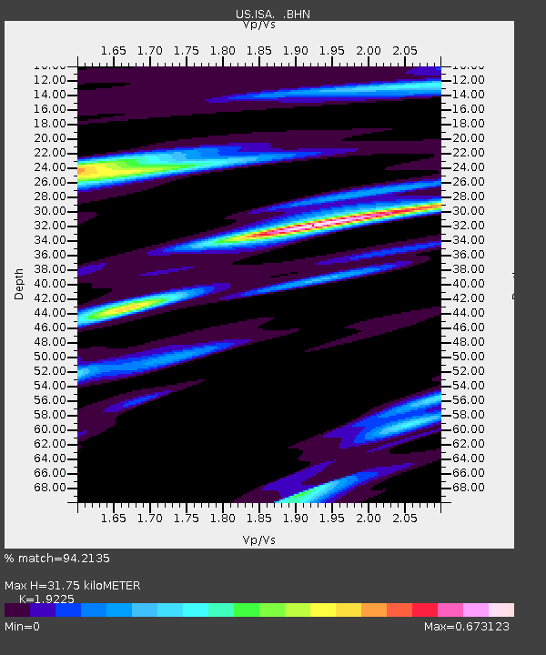
| Estimated Moho Depth: |
31.75 km |
| Estimated Crust Vp/Vs: |
1.92 |
| Assumed Crust Vp: |
6.1 km/s |
| Estimated Crust Vs: |
3.173 km/s |
| Estimated Crust Poisson's Ratio: |
0.31 |
|
| Radial Match: |
94.2135 % |
| Radial Bump: |
391 |
| Transverse Match: |
91.23626 % |
| Transverse Bump: |
400 |
| SOD ConfigId: |
110165 |
| Insert Time: |
2010-03-05 06:47:04.459 +0000 |
| GWidth: |
2.5 |
| Max Bumps: |
400 |
| Tol: |
0.001 |
|
Signal To Noise
| Channel | StoN | STA | LTA |
| US:ISA: :BHN:20030930T14:20:46.508005Z | 0.46884874 | 3.652236E-8 | 7.789796E-8 |
| US:ISA: :BHE:20030930T14:20:46.508005Z | 1.4532344 | 7.753839E-8 | 5.3355734E-8 |
| US:ISA: :BHZ:20030930T14:20:46.508005Z | 3.4580724 | 2.241283E-7 | 6.481307E-8 |
| Arrivals |
| Ps | 4.9 SECOND |
| PpPs | 15 SECOND |
| PsPs/PpSs | 20 SECOND |


