
Station US ISA - Isabella, Kern County, California, USA
Network: US - United States National Seismic Network
Nearby stations (2 deg radius)
| Station | Name | (Lat, Lon) | Start / End | Elevation |
| ISA | Isabella, Kern County, California, USA | (35.66, -118.47) | 1992-04-08 / 2499-01-01 | 873 m |
| Crust2 Type: | M1,extended crust, 3 km seds. |
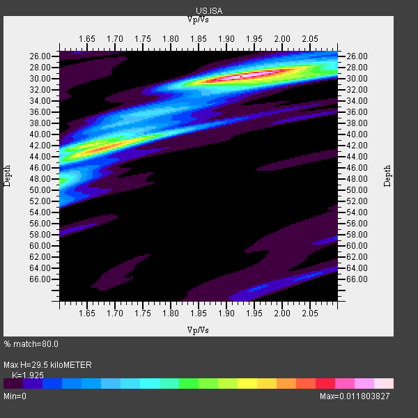
| Thickness Estimate: | 30 km |
| Thickness StdDev: | 6.9 km |
| Vp/Vs Estimate: | 1.92 |
| Vp/Vs StdDev: | 0.14 |
| Vs Estimate: | 3.169 km/s |
| Poisson's Ratio: | 0.32 |
| Peak Value: | 0.01 |
| Assumed Vp: | 6.1 km/s |
| Ps Weight: | 0.33333334 |
| PpPs Weight: | 0.33333334 |
| PsPs Weight: | 0.33333328 |
| Residual Complexity: | 0.627 |
| Nearby stations H: | 38 km +- 6.9 km |
| (2.0 deg) Vp/Vs: | 1.76 +- 0.14 |
10 with match > 90% ( 62.5 %) and 16 with match > 80% ( 100.0 %) out of 16.
Download stack as xyz text file.
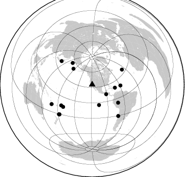
Azimuth Distribution of Events:
Prior Results for this Station
| Study | Thickness | Vp/Vs | Vp | Vs | Poissons Ratio | Extra |
| EARS | 30 km | 1.92 | 6.1 km/s | 3.169 km/s | 0.32 | |
| Crust2.0 | 31 km | 1.78 | 6.1 km/s | 3.426 km/s | 0.27 | M1,extended crust, 3 km seds. |
| Zhu S. Cal. | 37 km | 1.78 | 6.3 km/s | 3.539 km/s | 0.27 | |
| Global Maxima | 30 km | 1.92 | 6.1 km/s | 3.169 km/s | 0.32 | amp=0.011803827 |
| Local Maxima 1 | 42 km | 1.68 | 6.1 km/s | 3.642 km/s | 0.22 | amp=0.0089203315 |
| Local Maxima 2 | 30 km | 2.04 | 6.1 km/s | 2.987 km/s | 0.34 | amp=0.0049666413 |
| Local Maxima 3 | 42 km | 1.65 | 6.1 km/s | 3.697 km/s | 0.21 | amp=0.004842098 |
| Local Maxima 4 | 48 km | 1.60 | 6.1 km/s | 3.812 km/s | 0.18 | amp=0.0028600525 |
| Predicted Arrivals for vertical incidence (zero ray parameter) | |
| Ps | 4.47 SECOND |
| PpPs | 14.15 SECOND |
| PsPs/PpSs | 18.62 SECOND |
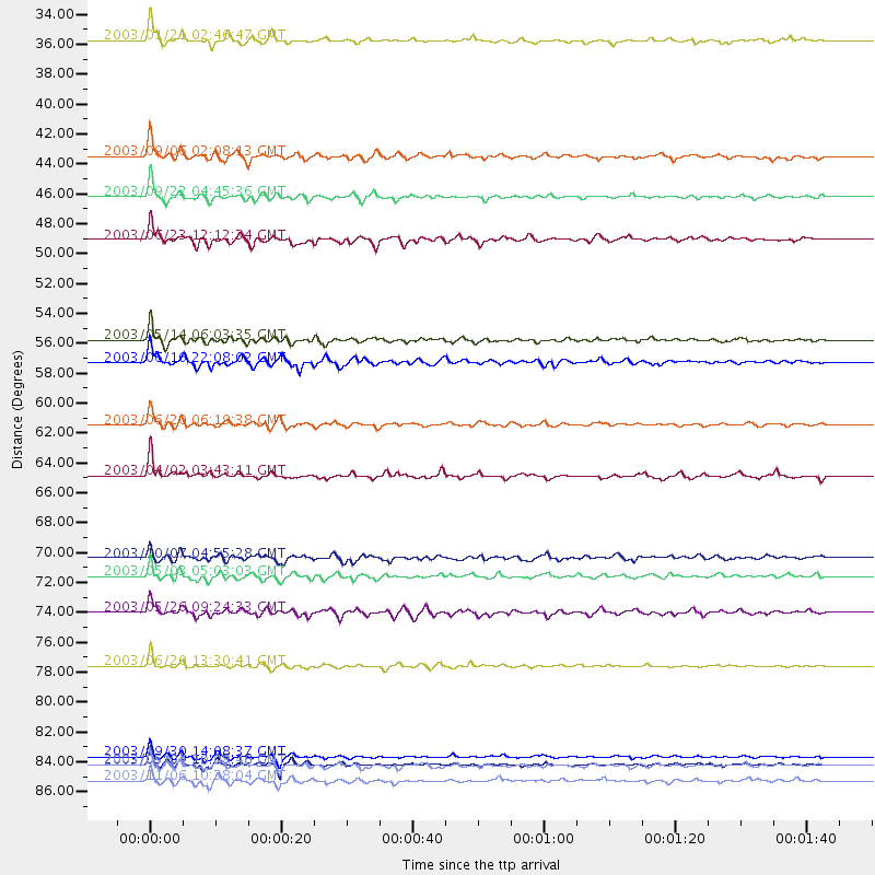
Events Processed for this Station
Download zip of receiver functions as SAC
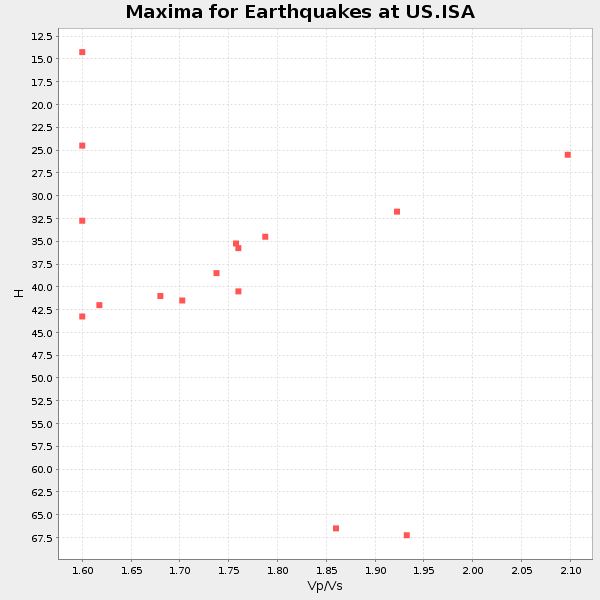
Plot maxima for each earthquake.
Events Used in the Stack
(16 events)| Radial Match | Distance | Baz | FERegion | Time | Lat/Lon | Depth | Magnitude |
| 96.39323 | 79.3 deg | 140.203 deg | Near Coast Of Central Chile | 2003/06/20 13:30:41 GMT | (-30.6, -71.6) | 33 km | 6.4 MB, 6.8 MS, 6.8 MW, 6.7 MW |
| 96.360886 | 33.2 deg | 124.362 deg | Near Coast Of Guatemala | 2003/01/21 02:46:47 GMT | (13.6, -90.8) | 24 km | 5.5 MB, 6.3 MS, 6.5 MW, 6.3 MW |
| 94.340645 | 55.3 deg | 91.632 deg | North Atlantic Ocean | 2003/05/14 06:03:35 GMT | (18.3, -58.6) | 42 km | 6.5 MB, 6.5 MS, 6.6 MW, 6.6 MW |
| 94.27246 | 44.7 deg | 97.615 deg | Dominican Republic Region | 2003/09/22 04:45:36 GMT | (19.8, -70.7) | 10 km | 6.2 MB, 6.6 MS, 6.5 MW, 6.4 MW |
| 94.2135 | 86.0 deg | 227.864 deg | Kermadec Islands, New Zealand | 2003/09/30 14:08:37 GMT | (-30.4, -177.4) | 10 km | 5.8 MB, 6.5 MS, 6.4 MW, 6.4 MW |
| 94.06537 | 86.5 deg | 228.312 deg | Kermadec Islands, New Zealand | 2003/05/04 13:15:18 GMT | (-30.5, -178.2) | 62 km | 6.0 MB, 6.5 MS, 6.7 MW, 6.7 MW |
| 94.041504 | 61.5 deg | 124.771 deg | Western Brazil | 2003/06/20 06:19:38 GMT | (-7.6, -71.7) | 558 km | 6.4 MB, 7.1 MW, 7.0 MW |
| 93.22805 | 56.9 deg | 317.806 deg | Kamchatka Peninsula, Russia | 2003/06/16 22:08:02 GMT | (55.5, 160.0) | 175 km | 6.3 MB, 6.9 MW, 6.9 MW |
| 91.14367 | 41.7 deg | 161.2 deg | Central East Pacific Rise | 2003/09/06 02:08:13 GMT | (-4.6, -106.0) | 10 km | 5.4 MB, 5.8 MS, 6.1 MW, 6.0 MW |
| 90.22859 | 47.9 deg | 310.3 deg | Rat Islands, Aleutian Islands | 2003/06/23 12:12:34 GMT | (51.4, 176.8) | 20 km | 6.3 MB, 7.0 MS, 6.9 MW, 6.8 MW |
| 88.004555 | 72.7 deg | 236.231 deg | Tonga Islands | 2003/05/03 05:03:03 GMT | (-15.1, -173.7) | 33 km | 6.3 MB, 6.1 MS, 6.2 MW, 6.1 MW |
| 86.721664 | 87.7 deg | 244.467 deg | Vanuatu Islands | 2003/11/06 10:38:04 GMT | (-19.3, 168.9) | 114 km | 6.0 MB, 6.6 MW, 6.6 MW |
| 85.6748 | 75.4 deg | 307.356 deg | Near East Coast Of Honshu, Japan | 2003/05/26 09:24:33 GMT | (38.8, 141.6) | 68 km | 6.7 MB, 7.0 MW, 7.0 MW |
| 84.12626 | 65.3 deg | 63.297 deg | Northern Mid-Atlantic Ridge | 2003/04/02 03:43:11 GMT | (35.3, -35.7) | 10 km | 5.5 MB, 5.6 MS, 6.3 MW, 6.1 MW |
| 82.909065 | 86.6 deg | 228.308 deg | Kermadec Islands, New Zealand | 2003/05/04 20:08:46 GMT | (-30.6, -178.3) | 46 km | 6.0 MB, 6.1 MS, 6.4 MW, 6.4 MW |
| 82.32533 | 71.3 deg | 232.626 deg | Samoa Islands Region | 2003/10/07 04:55:28 GMT | (-16.5, -170.2) | 10 km | 6.2 MB, 5.9 MS, 6.2 MW, 6.2 MW |
Losers
(0 events)| Radial Match | Distance | Baz | FERegion | Time | Lat/Lon | Depth | Magnitude | Reason |
