You are here: Home > Network List > US - United States National Seismic Network Stations List
> Station ISA Isabella, Kern County, California, USA > Earthquake Result Viewer
ISA Isabella, Kern County, California, USA - Earthquake Result Viewer
| Earthquake location: |
Kermadec Islands, New Zealand |
| Earthquake latitude/longitude: |
-30.5/-178.2 |
| Earthquake time(UTC): |
2003/05/04 (124) 13:15:18 GMT |
| Earthquake Depth: |
62 km |
| Earthquake Magnitude: |
6.0 MB, 6.5 MS, 6.7 MW, 6.7 MW |
| Earthquake Catalog/Contributor: |
WHDF/NEIC |
|
| Network: |
US United States National Seismic Network |
| Station: |
ISA Isabella, Kern County, California, USA |
| Lat/Lon: |
35.66 N/118.47 W |
| Elevation: |
873 m |
|
| Distance: |
86.5 deg |
| Az: |
44.812 deg |
| Baz: |
228.312 deg |
| Ray Param: |
0.043867745 |
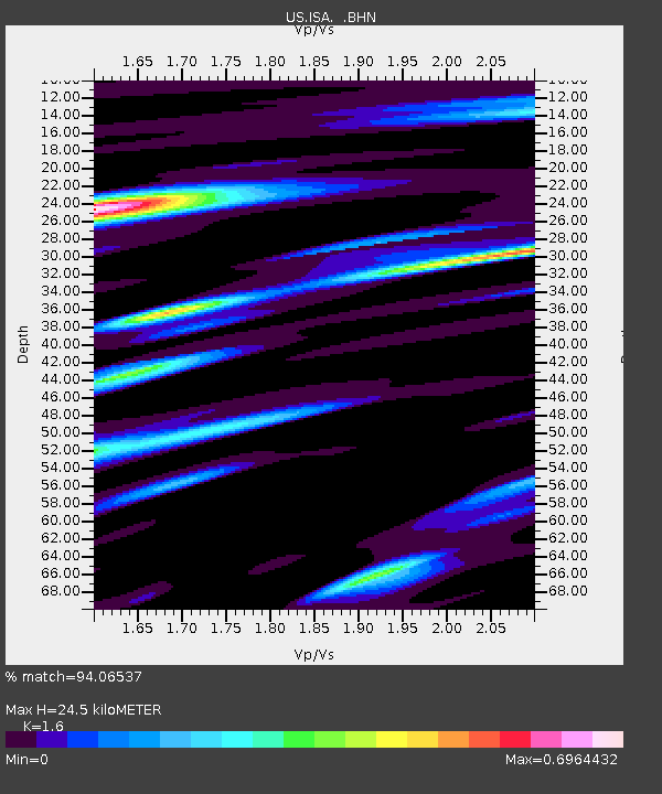
| Estimated Moho Depth: |
24.5 km |
| Estimated Crust Vp/Vs: |
1.60 |
| Assumed Crust Vp: |
6.1 km/s |
| Estimated Crust Vs: |
3.812 km/s |
| Estimated Crust Poisson's Ratio: |
0.18 |
|
| Radial Match: |
94.06537 % |
| Radial Bump: |
400 |
| Transverse Match: |
86.203674 % |
| Transverse Bump: |
400 |
| SOD ConfigId: |
110177 |
| Insert Time: |
2010-03-05 06:47:11.760 +0000 |
| GWidth: |
2.5 |
| Max Bumps: |
400 |
| Tol: |
0.001 |
|

Signal To Noise
| Channel | StoN | STA | LTA |
| US:ISA: :BHN:20030504T13:27:23.727993Z | 0.7988989 | 2.1307147E-7 | 2.6670642E-7 |
| US:ISA: :BHE:20030504T13:27:23.727993Z | 2.9536328 | 3.3485165E-7 | 1.13369424E-7 |
| US:ISA: :BHZ:20030504T13:27:23.727993Z | 14.595642 | 1.1192835E-6 | 7.668614E-8 |
| Arrivals |
| Ps | 2.5 SECOND |
| PpPs | 10 SECOND |
| PsPs/PpSs | 13 SECOND |


