You are here: Home > Network List > US - United States National Seismic Network Stations List
> Station ISA Isabella, Kern County, California, USA > Earthquake Result Viewer
ISA Isabella, Kern County, California, USA - Earthquake Result Viewer
| Earthquake location: |
Kamchatka Peninsula, Russia |
| Earthquake latitude/longitude: |
55.5/160.0 |
| Earthquake time(UTC): |
2003/06/16 (167) 22:08:02 GMT |
| Earthquake Depth: |
175 km |
| Earthquake Magnitude: |
6.3 MB, 6.9 MW, 6.9 MW |
| Earthquake Catalog/Contributor: |
WHDF/NEIC |
|
| Network: |
US United States National Seismic Network |
| Station: |
ISA Isabella, Kern County, California, USA |
| Lat/Lon: |
35.66 N/118.47 W |
| Elevation: |
873 m |
|
| Distance: |
56.9 deg |
| Az: |
73.953 deg |
| Baz: |
317.806 deg |
| Ray Param: |
0.06325237 |
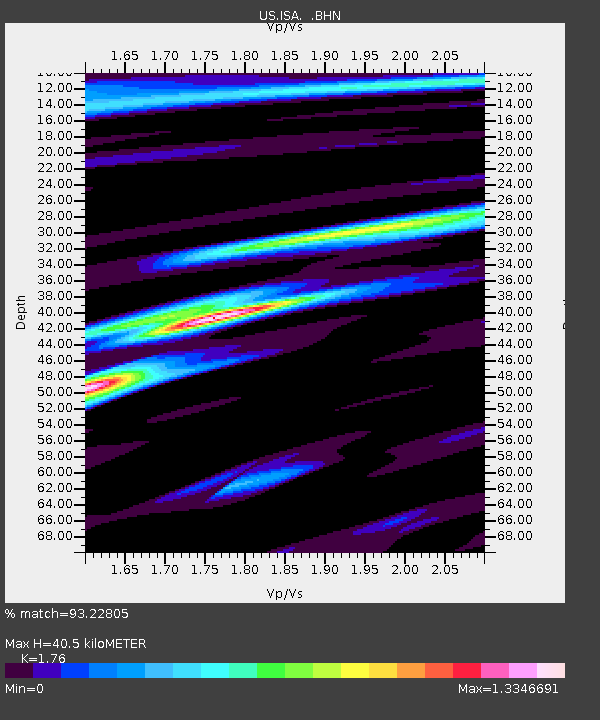
| Estimated Moho Depth: |
40.5 km |
| Estimated Crust Vp/Vs: |
1.76 |
| Assumed Crust Vp: |
6.1 km/s |
| Estimated Crust Vs: |
3.466 km/s |
| Estimated Crust Poisson's Ratio: |
0.26 |
|
| Radial Match: |
93.22805 % |
| Radial Bump: |
400 |
| Transverse Match: |
88.7556 % |
| Transverse Bump: |
400 |
| SOD ConfigId: |
110177 |
| Insert Time: |
2010-03-05 06:47:16.855 +0000 |
| GWidth: |
2.5 |
| Max Bumps: |
400 |
| Tol: |
0.001 |
|

Signal To Noise
| Channel | StoN | STA | LTA |
| US:ISA: :BHN:20030616T22:16:58.369004Z | 2.7535665 | 4.2512238E-7 | 1.5438972E-7 |
| US:ISA: :BHE:20030616T22:16:58.369004Z | 1.6441468 | 2.7343805E-7 | 1.6631E-7 |
| US:ISA: :BHZ:20030616T22:16:58.369004Z | 5.098957 | 1.11224E-6 | 2.181309E-7 |
| Arrivals |
| Ps | 5.3 SECOND |
| PpPs | 18 SECOND |
| PsPs/PpSs | 23 SECOND |


