You are here: Home > Network List > US - United States National Seismic Network Stations List
> Station ISA Isabella, Kern County, California, USA > Earthquake Result Viewer
ISA Isabella, Kern County, California, USA - Earthquake Result Viewer
| Earthquake location: |
Near Coast Of Central Chile |
| Earthquake latitude/longitude: |
-30.6/-71.6 |
| Earthquake time(UTC): |
2003/06/20 (171) 13:30:41 GMT |
| Earthquake Depth: |
33 km |
| Earthquake Magnitude: |
6.4 MB, 6.8 MS, 6.8 MW, 6.7 MW |
| Earthquake Catalog/Contributor: |
WHDF/NEIC |
|
| Network: |
US United States National Seismic Network |
| Station: |
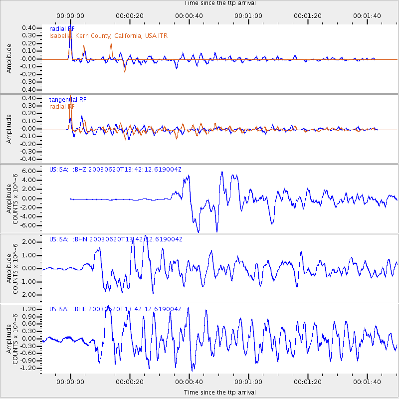
ISA Isabella, Kern County, California, USA |
| Lat/Lon: |
35.66 N/118.47 W |
| Elevation: |
873 m |
|
| Distance: |
79.3 deg |
| Az: |
322.804 deg |
| Baz: |
140.203 deg |
| Ray Param: |
0.04903143 |
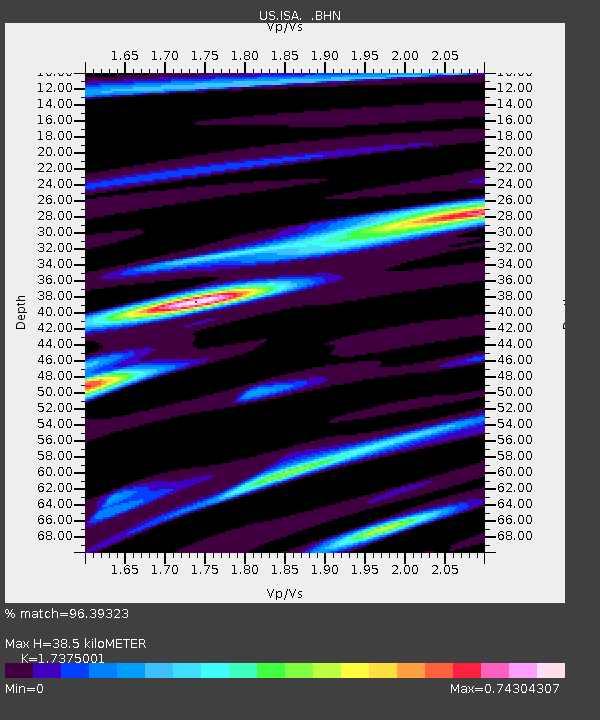
| Estimated Moho Depth: |
38.5 km |
| Estimated Crust Vp/Vs: |
1.74 |
| Assumed Crust Vp: |
6.1 km/s |
| Estimated Crust Vs: |
3.511 km/s |
| Estimated Crust Poisson's Ratio: |
0.25 |
|
| Radial Match: |
96.39323 % |
| Radial Bump: |
400 |
| Transverse Match: |
93.93082 % |
| Transverse Bump: |
400 |
| SOD ConfigId: |
110177 |
| Insert Time: |
2010-03-05 06:47:19.238 +0000 |
| GWidth: |
2.5 |
| Max Bumps: |
400 |
| Tol: |
0.001 |
|
Signal To Noise
| Channel | StoN | STA | LTA |
| US:ISA: :BHN:20030620T13:42:12.619004Z | 1.5873007 | 1.2842754E-7 | 8.09094E-8 |
| US:ISA: :BHE:20030620T13:42:12.619004Z | 0.83210164 | 6.273775E-8 | 7.5396734E-8 |
| US:ISA: :BHZ:20030620T13:42:12.619004Z | 6.3780107 | 4.3181007E-7 | 6.770294E-8 |
| Arrivals |
| Ps | 4.8 SECOND |
| PpPs | 17 SECOND |
| PsPs/PpSs | 22 SECOND |


