You are here: Home > Network List > US - United States National Seismic Network Stations List
> Station ISA Isabella, Kern County, California, USA > Earthquake Result Viewer
ISA Isabella, Kern County, California, USA - Earthquake Result Viewer
| Earthquake location: |
Rat Islands, Aleutian Islands |
| Earthquake latitude/longitude: |
51.4/176.8 |
| Earthquake time(UTC): |
2003/06/23 (174) 12:12:34 GMT |
| Earthquake Depth: |
20 km |
| Earthquake Magnitude: |
6.3 MB, 7.0 MS, 6.9 MW, 6.8 MW |
| Earthquake Catalog/Contributor: |
WHDF/NEIC |
|
| Network: |
US United States National Seismic Network |
| Station: |
ISA Isabella, Kern County, California, USA |
| Lat/Lon: |
35.66 N/118.47 W |
| Elevation: |
873 m |
|
| Distance: |
47.9 deg |
| Az: |
82.855 deg |
| Baz: |
310.3 deg |
| Ray Param: |
0.06966003 |
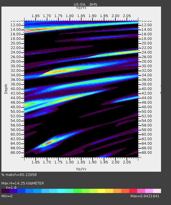
| Estimated Moho Depth: |
14.25 km |
| Estimated Crust Vp/Vs: |
1.60 |
| Assumed Crust Vp: |
6.1 km/s |
| Estimated Crust Vs: |
3.812 km/s |
| Estimated Crust Poisson's Ratio: |
0.18 |
|
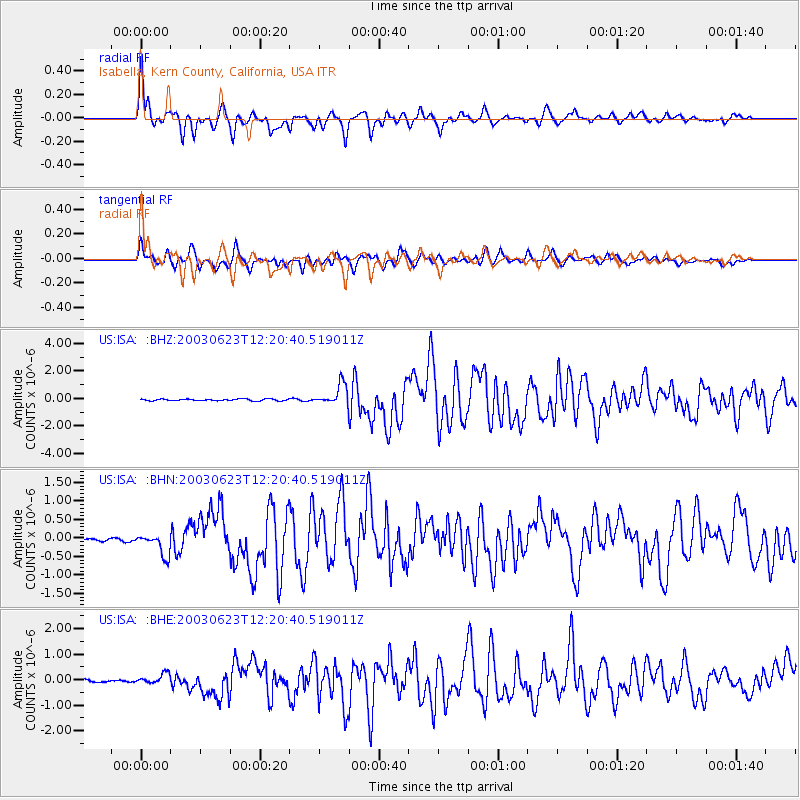
| Radial Match: |
90.22859 % |
| Radial Bump: |
400 |
| Transverse Match: |
88.71517 % |
| Transverse Bump: |
400 |
| SOD ConfigId: |
110177 |
| Insert Time: |
2010-03-05 06:47:20.326 +0000 |
| GWidth: |
2.5 |
| Max Bumps: |
400 |
| Tol: |
0.001 |
|
Signal To Noise
| Channel | StoN | STA | LTA |
| US:ISA: :BHN:20030623T12:20:40.519011Z | 6.987646 | 3.0534594E-7 | 4.369797E-8 |
| US:ISA: :BHE:20030623T12:20:40.519011Z | 3.1344788 | 2.1501253E-7 | 6.8595945E-8 |
| US:ISA: :BHZ:20030623T12:20:40.519011Z | 12.135012 | 7.601856E-7 | 6.264399E-8 |
| Arrivals |
| Ps | 1.5 SECOND |
| PpPs | 5.7 SECOND |
| PsPs/PpSs | 7.2 SECOND |


