You are here: Home > Network List > US - United States National Seismic Network Stations List
> Station ISA Isabella, Kern County, California, USA > Earthquake Result Viewer
ISA Isabella, Kern County, California, USA - Earthquake Result Viewer
| Earthquake location: |
Dominican Republic Region |
| Earthquake latitude/longitude: |
19.8/-70.7 |
| Earthquake time(UTC): |
2003/09/22 (265) 04:45:36 GMT |
| Earthquake Depth: |
10 km |
| Earthquake Magnitude: |
6.2 MB, 6.6 MS, 6.5 MW, 6.4 MW |
| Earthquake Catalog/Contributor: |
WHDF/NEIC |
|
| Network: |
US United States National Seismic Network |
| Station: |
ISA Isabella, Kern County, California, USA |
| Lat/Lon: |
35.66 N/118.47 W |
| Elevation: |
873 m |
|
| Distance: |
44.7 deg |
| Az: |
301.011 deg |
| Baz: |
97.615 deg |
| Ray Param: |
0.07173218 |
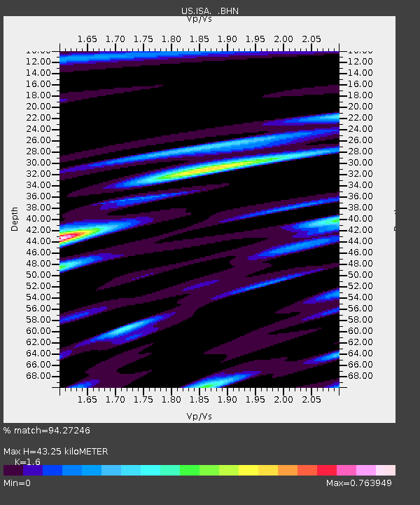
| Estimated Moho Depth: |
43.25 km |
| Estimated Crust Vp/Vs: |
1.60 |
| Assumed Crust Vp: |
6.1 km/s |
| Estimated Crust Vs: |
3.812 km/s |
| Estimated Crust Poisson's Ratio: |
0.18 |
|
| Radial Match: |
94.27246 % |
| Radial Bump: |
324 |
| Transverse Match: |
85.846794 % |
| Transverse Bump: |
400 |
| SOD ConfigId: |
110177 |
| Insert Time: |
2010-03-05 06:47:21.587 +0000 |
| GWidth: |
2.5 |
| Max Bumps: |
400 |
| Tol: |
0.001 |
|
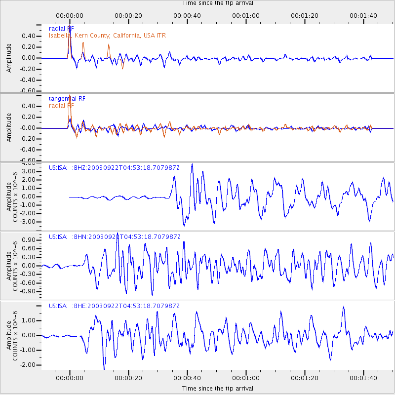
Signal To Noise
| Channel | StoN | STA | LTA |
| US:ISA: :BHN:20030922T04:53:18.707987Z | 0.9730378 | 4.2621508E-8 | 4.3802522E-8 |
| US:ISA: :BHE:20030922T04:53:18.707987Z | 1.6300834 | 1.0139951E-7 | 6.22051E-8 |
| US:ISA: :BHZ:20030922T04:53:18.707987Z | 1.852716 | 2.265022E-7 | 1.2225414E-7 |
| Arrivals |
| Ps | 4.5 SECOND |
| PpPs | 17 SECOND |
| PsPs/PpSs | 22 SECOND |


