You are here: Home > Network List > US - United States National Seismic Network Stations List
> Station ISA Isabella, Kern County, California, USA > Earthquake Result Viewer
ISA Isabella, Kern County, California, USA - Earthquake Result Viewer
| Earthquake location: |
Vanuatu Islands |
| Earthquake latitude/longitude: |
-19.3/168.9 |
| Earthquake time(UTC): |
2003/11/06 (310) 10:38:04 GMT |
| Earthquake Depth: |
114 km |
| Earthquake Magnitude: |
6.0 MB, 6.6 MW, 6.6 MW |
| Earthquake Catalog/Contributor: |
WHDF/NEIC |
|
| Network: |
US United States National Seismic Network |
| Station: |
ISA Isabella, Kern County, California, USA |
| Lat/Lon: |
35.66 N/118.47 W |
| Elevation: |
873 m |
|
| Distance: |
87.7 deg |
| Az: |
51.059 deg |
| Baz: |
244.467 deg |
| Ray Param: |
0.042854108 |
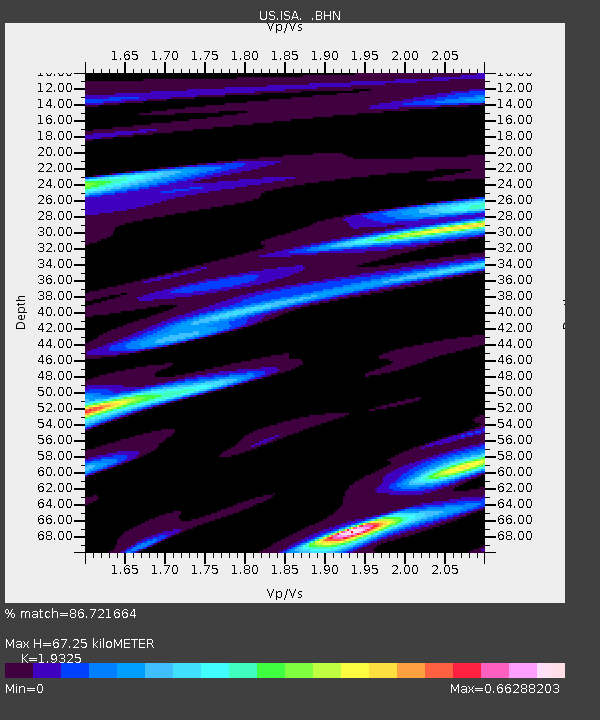
| Estimated Moho Depth: |
67.25 km |
| Estimated Crust Vp/Vs: |
1.93 |
| Assumed Crust Vp: |
6.1 km/s |
| Estimated Crust Vs: |
3.157 km/s |
| Estimated Crust Poisson's Ratio: |
0.32 |
|
| Radial Match: |
86.721664 % |
| Radial Bump: |
400 |
| Transverse Match: |
87.68193 % |
| Transverse Bump: |
400 |
| SOD ConfigId: |
110177 |
| Insert Time: |
2010-03-05 06:47:25.724 +0000 |
| GWidth: |
2.5 |
| Max Bumps: |
400 |
| Tol: |
0.001 |
|

Signal To Noise
| Channel | StoN | STA | LTA |
| US:ISA: :BHN:20031106T10:50:09.235007Z | 1.455114 | 1.2222486E-7 | 8.399676E-8 |
| US:ISA: :BHE:20031106T10:50:09.235007Z | 0.8992473 | 2.7482747E-7 | 3.0561944E-7 |
| US:ISA: :BHZ:20031106T10:50:09.235007Z | 5.5423617 | 1.2936215E-6 | 2.3340617E-7 |
| Arrivals |
| Ps | 10 SECOND |
| PpPs | 32 SECOND |
| PsPs/PpSs | 42 SECOND |


