You are here: Home > Network List > US - United States National Seismic Network Stations List
> Station CCM Cathedral Cave, Missouri, USA > Earthquake Result Viewer
CCM Cathedral Cave, Missouri, USA - Earthquake Result Viewer

| Earthquake location: |
Panama-Costa Rica Border Region |
| Earthquake latitude/longitude: |
8.4/-82.9 |
| Earthquake time(UTC): |
2004/02/04 (035) 11:59:47 GMT |
| Earthquake Depth: |
29 km |
| Earthquake Magnitude: |
5.6 MB, 5.9 MS, 6.1 MW, 6.1 MW |
| Earthquake Catalog/Contributor: |
WHDF/NEIC |
|
| Network: |
US United States National Seismic Network |
| Station: |
CCM Cathedral Cave, Missouri, USA |
| Lat/Lon: |
38.06 N/91.24 W |
| Elevation: |
222 m |
|
| Distance: |
30.5 deg |
| Az: |
346.925 deg |
| Baz: |
163.527 deg |
| Ray Param: |
0.079285584 |
| Estimated Moho Depth: |
50.75 km |
| Estimated Crust Vp/Vs: |
1.60 |
| Assumed Crust Vp: |
6.498 km/s |
| Estimated Crust Vs: |
4.061 km/s |
| Estimated Crust Poisson's Ratio: |
0.18 |
|
| Radial Match: |
89.57191 % |
| Radial Bump: |
280 |
| Transverse Match: |
60.35756 % |
| Transverse Bump: |
400 |
| SOD ConfigId: |
110177 |
| Insert Time: |
2010-03-05 06:51:02.810 +0000 |
| GWidth: |
2.5 |
| Max Bumps: |
400 |
| Tol: |
0.001 |
|
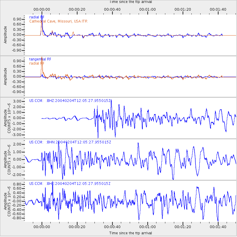
Signal To Noise
| Channel | StoN | STA | LTA |
| US:CCM: :BHN:20040204T12:05:27.955015Z | 3.7807357 | 7.620874E-7 | 2.015712E-7 |
| US:CCM: :BHE:20040204T12:05:27.955015Z | 2.2177684 | 2.6501658E-7 | 1.1949696E-7 |
| US:CCM: :BHZ:20040204T12:05:27.955015Z | 6.856003 | 1.0555472E-6 | 1.5395956E-7 |
| Arrivals |
| Ps | 5.1 SECOND |
| PpPs | 19 SECOND |
| PsPs/PpSs | 24 SECOND |


