
Station US CCM - Cathedral Cave, Missouri, USA
Network: US - United States National Seismic Network
Nearby stations (2 deg radius)
| Station | Name | (Lat, Lon) | Start / End | Elevation |
| CCM | Cathedral Cave, Missouri, USA | (38.06, -91.24) | 2003-01-01 / 2499-01-01 | 222 m |
| Crust2 Type: | D9,Platform 1 km seds. |
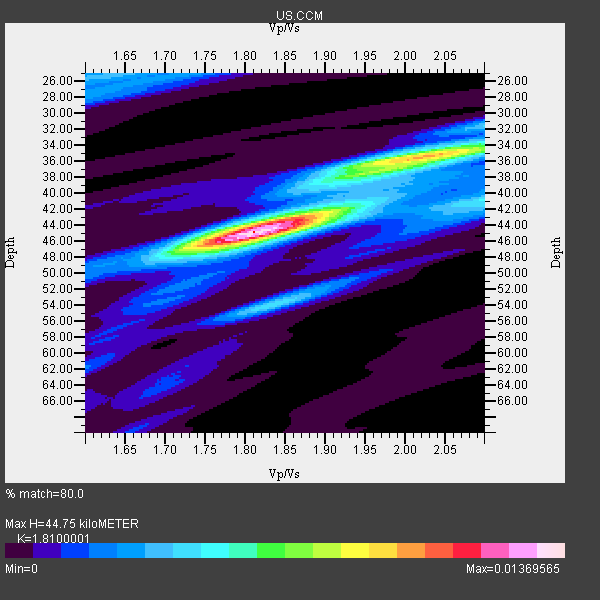
| Thickness Estimate: | 45 km |
| Thickness StdDev: | 4.4 km |
| Vp/Vs Estimate: | 1.81 |
| Vp/Vs StdDev: | 0.10 |
| Vs Estimate: | 3.59 km/s |
| Poisson's Ratio: | 0.28 |
| Peak Value: | 0.01 |
| Assumed Vp: | 6.498 km/s |
| Ps Weight: | 0.33333334 |
| PpPs Weight: | 0.33333334 |
| PsPs Weight: | 0.33333328 |
| Residual Complexity: | 0.589 |
| Nearby stations H: | 46 km +- 0.7 km |
| (2.0 deg) Vp/Vs: | 1.79 +- 0.03 |
11 with match > 90% ( 45.833332 %) and 24 with match > 80% ( 100.0 %) out of 24.
Download stack as xyz text file.
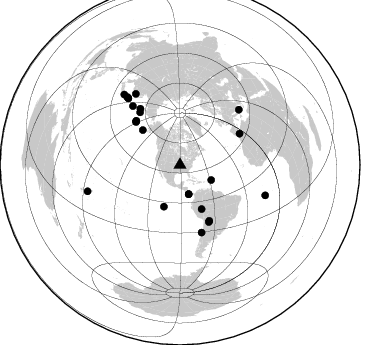
Azimuth Distribution of Events:
Prior Results for this Station
| Study | Thickness | Vp/Vs | Vp | Vs | Poissons Ratio | Extra |
| EARS | 45 km | 1.81 | 6.498 km/s | 3.59 km/s | 0.28 | |
| Crust2.0 | 41 km | 1.77 | 6.498 km/s | 3.666 km/s | 0.27 | D9,Platform 1 km seds. |
| MOMA | 41 km | 1.84 | 6.6 km/s | 3.587 km/s | 0.29 | |
| MOMA | 43 km | 1.80 | 6.6 km/s | 3.667 km/s | 0.28 | |
| MOMA | 45 km | 1.73 | 6.5 km/s | 3.757 km/s | 0.25 | |
| Zandt Ammon | 37 km | 1.81 | 6.0 km/s | 3.315 km/s | 0.28 | |
| Zandt Ammon | 39 km | 1.80 | 6.25 km/s | 3.472 km/s | 0.28 | |
| Zandt Ammon | 41 km | 1.80 | 6.5 km/s | 3.611 km/s | 0.28 | |
| Zandt Ammon | 42 km | 1.79 | 6.75 km/s | 3.771 km/s | 0.27 | |
| Global Maxima | 45 km | 1.81 | 6.498 km/s | 3.59 km/s | 0.28 | amp=0.01369565 |
| Local Maxima 1 | 35 km | 2.03 | 6.498 km/s | 3.209 km/s | 0.34 | amp=0.008520096 |
| Local Maxima 2 | 54 km | 1.84 | 6.498 km/s | 3.536 km/s | 0.29 | amp=0.0046146596 |
| Local Maxima 3 | 25 km | 1.62 | 6.498 km/s | 3.998 km/s | 0.20 | amp=0.0038102975 |
| Local Maxima 4 | 42 km | 1.90 | 6.498 km/s | 3.424 km/s | 0.31 | amp=0.0036802574 |
| Predicted Arrivals for vertical incidence (zero ray parameter) | |
| Ps | 5.58 SECOND |
| PpPs | 19.35 SECOND |
| PsPs/PpSs | 24.93 SECOND |
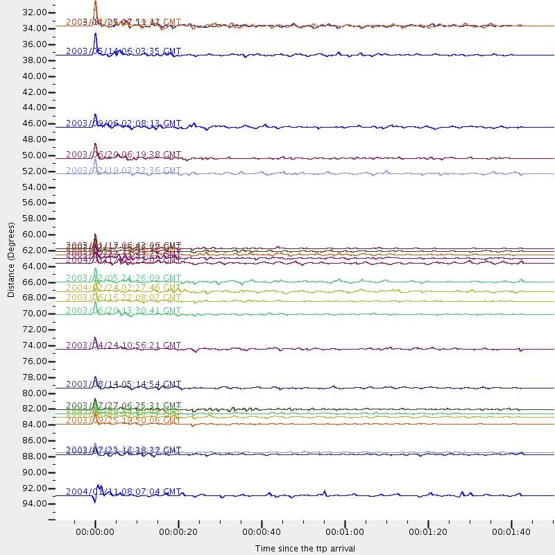
Events Processed for this Station
Download zip of receiver functions as SAC
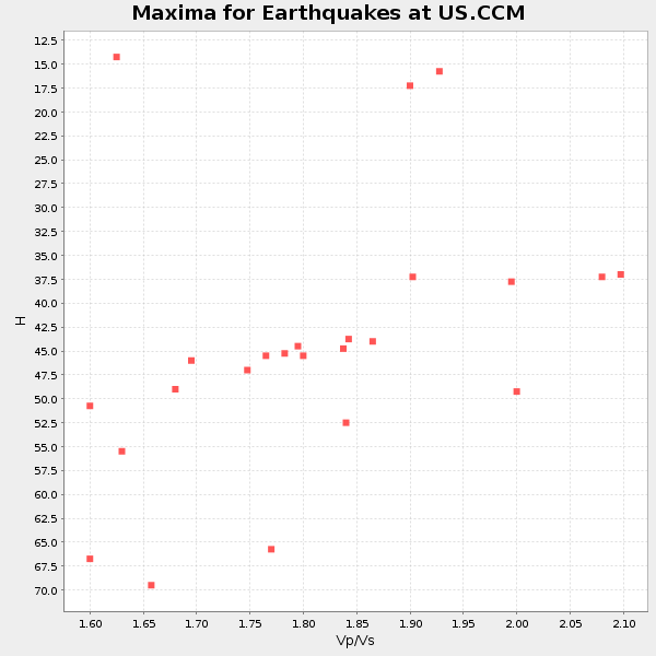
Plot maxima for each earthquake.
Events Used in the Stack
(24 events)| Radial Match | Distance | Baz | FERegion | Time | Lat/Lon | Depth | Magnitude |
| 99.08628 | 86.0 deg | 322.046 deg | Hokkaido, Japan Region | 2003/09/25 19:50:06 GMT | (41.8, 143.9) | 27 km | 6.9 MB, 8.1 MS, 8.3 MW, 8.1 MW |
| 98.94613 | 70.7 deg | 162.151 deg | Near Coast Of Central Chile | 2003/06/20 13:30:41 GMT | (-30.6, -71.6) | 33 km | 6.4 MB, 6.8 MS, 6.8 MW, 6.7 MW |
| 98.1048 | 68.9 deg | 324.712 deg | Kamchatka Peninsula, Russia | 2003/06/16 22:08:02 GMT | (55.5, 160.0) | 175 km | 6.3 MB, 6.9 MW, 6.9 MW |
| 96.73613 | 61.6 deg | 314.26 deg | Rat Islands, Aleutian Islands | 2003/11/17 06:43:06 GMT | (51.1, 178.6) | 33 km | 6.2 MB, 7.2 MS, 7.8 MW, 7.7 MW |
| 95.608086 | 48.9 deg | 153.938 deg | Western Brazil | 2003/06/20 06:19:38 GMT | (-7.6, -71.7) | 558 km | 6.4 MB, 7.1 MW, 7.0 MW |
| 95.54299 | 90.0 deg | 321.607 deg | Eastern Honshu, Japan | 2003/07/25 22:13:29 GMT | (38.4, 141.0) | 6.0 km | 6.0 MB, 5.8 MS, 6.1 MW, 5.9 MW |
| 95.11725 | 83.9 deg | 328.024 deg | Primor'ye, Russia | 2003/07/27 06:25:31 GMT | (47.2, 139.2) | 470 km | 6.3 MB, 6.8 MW, 6.8 MW |
| 94.08053 | 34.6 deg | 115.604 deg | North Atlantic Ocean | 2003/05/14 06:03:35 GMT | (18.3, -58.6) | 42 km | 6.5 MB, 6.5 MS, 6.6 MW, 6.6 MW |
| 93.810616 | 84.5 deg | 322.019 deg | Hokkaido, Japan Region | 2004/12/06 14:15:11 GMT | (42.9, 145.2) | 35 km | 6.5 MB, 6.5 MS, 6.8 MW, 6.8 MW |
| 92.69739 | 30.5 deg | 163.4 deg | Panama-Costa Rica Border Region | 2003/12/25 07:11:11 GMT | (8.4, -82.8) | 33 km | 6.0 MB, 6.4 MS, 6.5 MW, 6.5 MW |
| 91.70123 | 80.9 deg | 46.949 deg | Greece-Albania Border Region | 2003/08/14 05:14:54 GMT | (39.2, 20.6) | 10 km | 5.6 MB, 6.2 MS, 6.3 MW, 6.2 MW |
| 89.57191 | 30.5 deg | 163.527 deg | Panama-Costa Rica Border Region | 2004/02/04 11:59:47 GMT | (8.4, -82.9) | 29 km | 5.6 MB, 5.9 MS, 6.1 MW, 6.1 MW |
| 89.531654 | 61.9 deg | 314.602 deg | Rat Islands, Aleutian Islands | 2003/03/17 16:36:17 GMT | (51.3, 178.0) | 33 km | 5.9 MB, 6.7 MS, 7.0 MW, 7.0 MW |
| 89.46462 | 85.0 deg | 322.219 deg | Hokkaido, Japan Region | 2003/10/08 09:06:55 GMT | (42.6, 144.6) | 32 km | 6.0 MB, 6.6 MS, 6.7 MW, 6.6 MW |
| 89.321495 | 62.9 deg | 152.361 deg | Southern Bolivia | 2003/07/27 11:41:27 GMT | (-20.1, -65.2) | 345 km | 5.9 MB, 6.0 MW, 6.0 MW |
| 89.18896 | 51.1 deg | 312.881 deg | Unimak Island Region, Alaska | 2003/02/19 03:32:36 GMT | (53.6, -164.6) | 19 km | 5.8 MB, 6.6 MS, 6.6 MW, 6.6 MW |
| 85.449104 | 62.4 deg | 315.222 deg | Rat Islands, Aleutian Islands | 2003/06/15 19:24:33 GMT | (51.6, 176.9) | 20 km | 6.0 MB, 6.4 MS, 6.5 MW, 6.5 MW |
| 84.368195 | 90.3 deg | 109.568 deg | Southern Mid-Atlantic Ridge | 2003/07/23 16:38:37 GMT | (-15.6, -13.4) | 10 km | 5.8 MB, 5.2 MS, 5.8 MW, 5.6 MW |
| 83.861435 | 75.5 deg | 321.29 deg | Kuril Islands | 2003/04/24 10:56:21 GMT | (48.8, 155.0) | 44 km | 5.6 MB, 5.7 MS, 6.1 MW, 6.0 MW |
| 83.31893 | 66.2 deg | 322.726 deg | Komandorskiye Ostrova Region | 2003/12/05 21:26:09 GMT | (55.5, 165.8) | 10 km | 6.1 MB, 6.5 MS, 6.7 MW, 6.7 MW |
| 82.12594 | 95.9 deg | 254.161 deg | Fiji Islands Region | 2004/01/11 08:07:04 GMT | (-16.2, -176.2) | 366 km | 5.3 MB, 5.9 MW, 5.9 MW |
| 81.45193 | 44.6 deg | 201.25 deg | Central East Pacific Rise | 2003/09/06 02:08:13 GMT | (-4.6, -106.0) | 10 km | 5.4 MB, 5.8 MS, 6.1 MW, 6.0 MW |
| 81.07234 | 63.6 deg | 153.172 deg | Southern Bolivia | 2004/03/17 03:21:07 GMT | (-21.1, -65.6) | 290 km | 5.5 MB, 6.1 MW, 6.1 MW |
| 80.05235 | 67.5 deg | 62.387 deg | Strait Of Gibraltar | 2004/02/24 02:27:46 GMT | (35.1, -4.0) | 0.0 km | 6.2 MB, 6.4 MS, 6.4 MW, 6.4 MW |
Losers
(0 events)| Radial Match | Distance | Baz | FERegion | Time | Lat/Lon | Depth | Magnitude | Reason |
