You are here: Home > Network List > US - United States National Seismic Network Stations List
> Station CCM Cathedral Cave, Missouri, USA > Earthquake Result Viewer
CCM Cathedral Cave, Missouri, USA - Earthquake Result Viewer
| Earthquake location: |
Strait Of Gibraltar |
| Earthquake latitude/longitude: |
35.1/-4.0 |
| Earthquake time(UTC): |
2004/02/24 (055) 02:27:46 GMT |
| Earthquake Depth: |
0.0 km |
| Earthquake Magnitude: |
6.2 MB, 6.4 MS, 6.4 MW, 6.4 MW |
| Earthquake Catalog/Contributor: |
WHDF/NEIC |
|
| Network: |
US United States National Seismic Network |
| Station: |
CCM Cathedral Cave, Missouri, USA |
| Lat/Lon: |
38.06 N/91.24 W |
| Elevation: |
222 m |
|
| Distance: |
67.5 deg |
| Az: |
301.403 deg |
| Baz: |
62.387 deg |
| Ray Param: |
0.056942087 |
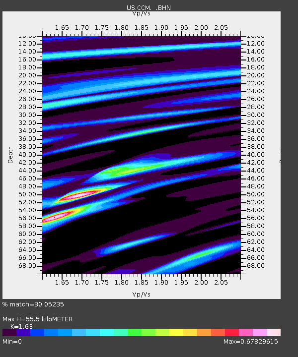
| Estimated Moho Depth: |
55.5 km |
| Estimated Crust Vp/Vs: |
1.63 |
| Assumed Crust Vp: |
6.498 km/s |
| Estimated Crust Vs: |
3.986 km/s |
| Estimated Crust Poisson's Ratio: |
0.20 |
|
| Radial Match: |
80.05235 % |
| Radial Bump: |
400 |
| Transverse Match: |
64.44839 % |
| Transverse Bump: |
400 |
| SOD ConfigId: |
110177 |
| Insert Time: |
2010-03-05 06:51:03.572 +0000 |
| GWidth: |
2.5 |
| Max Bumps: |
400 |
| Tol: |
0.001 |
|

Signal To Noise
| Channel | StoN | STA | LTA |
| US:CCM: :BHN:20040224T02:38:12.709004Z | 1.8467695 | 2.536255E-7 | 1.3733468E-7 |
| US:CCM: :BHE:20040224T02:38:12.709004Z | 3.192484 | 3.9247206E-7 | 1.2293627E-7 |
| US:CCM: :BHZ:20040224T02:38:12.709004Z | 6.58992 | 9.960721E-7 | 1.5115087E-7 |
| Arrivals |
| Ps | 5.6 SECOND |
| PpPs | 21 SECOND |
| PsPs/PpSs | 27 SECOND |


