You are here: Home > Network List > US - United States National Seismic Network Stations List
> Station CCM Cathedral Cave, Missouri, USA > Earthquake Result Viewer
CCM Cathedral Cave, Missouri, USA - Earthquake Result Viewer

| Earthquake location: |
Southern Mid-Atlantic Ridge |
| Earthquake latitude/longitude: |
-15.6/-13.4 |
| Earthquake time(UTC): |
2003/07/23 (204) 16:38:37 GMT |
| Earthquake Depth: |
10 km |
| Earthquake Magnitude: |
5.8 MB, 5.2 MS, 5.8 MW, 5.6 MW |
| Earthquake Catalog/Contributor: |
WHDF/NEIC |
|
| Network: |
US United States National Seismic Network |
| Station: |
CCM Cathedral Cave, Missouri, USA |
| Lat/Lon: |
38.06 N/91.24 W |
| Elevation: |
222 m |
|
| Distance: |
90.3 deg |
| Az: |
309.478 deg |
| Baz: |
109.568 deg |
| Ray Param: |
0.041686535 |
| Estimated Moho Depth: |
17.25 km |
| Estimated Crust Vp/Vs: |
1.90 |
| Assumed Crust Vp: |
6.498 km/s |
| Estimated Crust Vs: |
3.42 km/s |
| Estimated Crust Poisson's Ratio: |
0.31 |
|
| Radial Match: |
84.368195 % |
| Radial Bump: |
345 |
| Transverse Match: |
70.781746 % |
| Transverse Bump: |
400 |
| SOD ConfigId: |
110177 |
| Insert Time: |
2010-03-05 06:51:17.341 +0000 |
| GWidth: |
2.5 |
| Max Bumps: |
400 |
| Tol: |
0.001 |
|
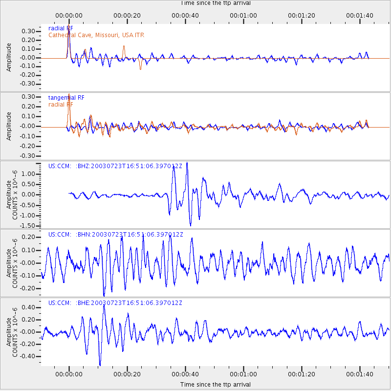
Signal To Noise
| Channel | StoN | STA | LTA |
| US:CCM: :BHN:20030723T16:51:06.397012Z | 0.81549376 | 4.2130097E-8 | 5.166207E-8 |
| US:CCM: :BHE:20030723T16:51:06.397012Z | 1.7413524 | 9.7195766E-8 | 5.581625E-8 |
| US:CCM: :BHZ:20030723T16:51:06.397012Z | 3.5009074 | 2.701646E-7 | 7.716989E-8 |
| Arrivals |
| Ps | 2.4 SECOND |
| PpPs | 7.5 SECOND |
| PsPs/PpSs | 10.0 SECOND |


