You are here: Home > Network List > US - United States National Seismic Network Stations List
> Station CCM Cathedral Cave, Missouri, USA > Earthquake Result Viewer
CCM Cathedral Cave, Missouri, USA - Earthquake Result Viewer

| Earthquake location: |
Primor'ye, Russia |
| Earthquake latitude/longitude: |
47.2/139.2 |
| Earthquake time(UTC): |
2003/07/27 (208) 06:25:31 GMT |
| Earthquake Depth: |
470 km |
| Earthquake Magnitude: |
6.3 MB, 6.8 MW, 6.8 MW |
| Earthquake Catalog/Contributor: |
WHDF/NEIC |
|
| Network: |
US United States National Seismic Network |
| Station: |
CCM Cathedral Cave, Missouri, USA |
| Lat/Lon: |
38.06 N/91.24 W |
| Elevation: |
222 m |
|
| Distance: |
83.9 deg |
| Az: |
37.771 deg |
| Baz: |
328.024 deg |
| Ray Param: |
0.04453395 |
| Estimated Moho Depth: |
66.75 km |
| Estimated Crust Vp/Vs: |
1.60 |
| Assumed Crust Vp: |
6.498 km/s |
| Estimated Crust Vs: |
4.061 km/s |
| Estimated Crust Poisson's Ratio: |
0.18 |
|
| Radial Match: |
95.11725 % |
| Radial Bump: |
400 |
| Transverse Match: |
86.77475 % |
| Transverse Bump: |
400 |
| SOD ConfigId: |
110177 |
| Insert Time: |
2010-03-05 06:51:19.038 +0000 |
| GWidth: |
2.5 |
| Max Bumps: |
400 |
| Tol: |
0.001 |
|
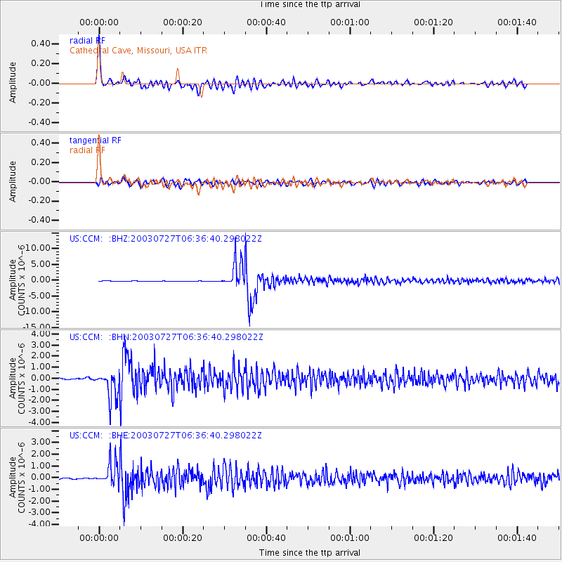
Signal To Noise
| Channel | StoN | STA | LTA |
| US:CCM: :BHN:20030727T06:36:40.298022Z | 24.671404 | 1.2238688E-6 | 4.9606776E-8 |
| US:CCM: :BHE:20030727T06:36:40.298022Z | 24.765318 | 9.941173E-7 | 4.014151E-8 |
| US:CCM: :BHZ:20030727T06:36:40.298022Z | 72.19735 | 4.186732E-6 | 5.7990107E-8 |
| Arrivals |
| Ps | 6.3 SECOND |
| PpPs | 26 SECOND |
| PsPs/PpSs | 32 SECOND |


