You are here: Home > Network List > US - United States National Seismic Network Stations List
> Station CCM Cathedral Cave, Missouri, USA > Earthquake Result Viewer
CCM Cathedral Cave, Missouri, USA - Earthquake Result Viewer

| Earthquake location: |
Southern Bolivia |
| Earthquake latitude/longitude: |
-20.1/-65.2 |
| Earthquake time(UTC): |
2003/07/27 (208) 11:41:27 GMT |
| Earthquake Depth: |
345 km |
| Earthquake Magnitude: |
5.9 MB, 6.0 MW, 6.0 MW |
| Earthquake Catalog/Contributor: |
WHDF/NEIC |
|
| Network: |
US United States National Seismic Network |
| Station: |
CCM Cathedral Cave, Missouri, USA |
| Lat/Lon: |
38.06 N/91.24 W |
| Elevation: |
222 m |
|
| Distance: |
62.9 deg |
| Az: |
337.062 deg |
| Baz: |
152.361 deg |
| Ray Param: |
0.058804914 |
| Estimated Moho Depth: |
47.0 km |
| Estimated Crust Vp/Vs: |
1.75 |
| Assumed Crust Vp: |
6.498 km/s |
| Estimated Crust Vs: |
3.718 km/s |
| Estimated Crust Poisson's Ratio: |
0.26 |
|
| Radial Match: |
89.321495 % |
| Radial Bump: |
400 |
| Transverse Match: |
72.87814 % |
| Transverse Bump: |
400 |
| SOD ConfigId: |
110177 |
| Insert Time: |
2010-03-05 06:51:19.866 +0000 |
| GWidth: |
2.5 |
| Max Bumps: |
400 |
| Tol: |
0.001 |
|
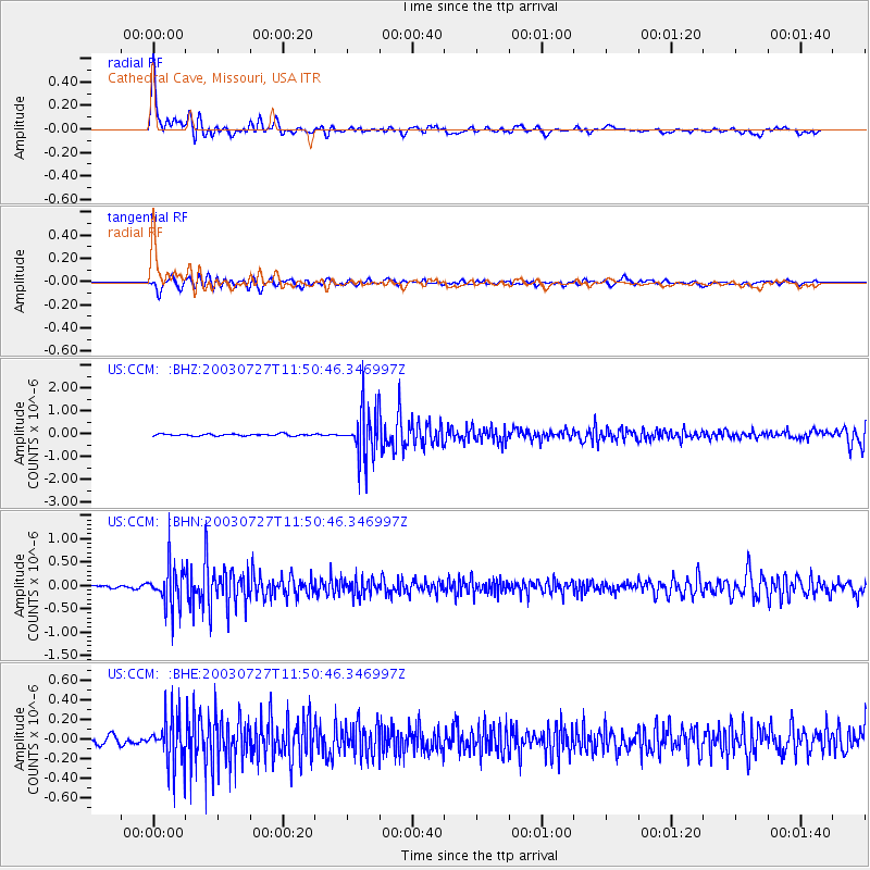
Signal To Noise
| Channel | StoN | STA | LTA |
| US:CCM: :BHN:20030727T11:50:46.346997Z | 12.716495 | 4.360057E-7 | 3.4286625E-8 |
| US:CCM: :BHE:20030727T11:50:46.346997Z | 5.9920144 | 2.406726E-7 | 4.0165553E-8 |
| US:CCM: :BHZ:20030727T11:50:46.346997Z | 24.5107 | 1.0182071E-6 | 4.154133E-8 |
| Arrivals |
| Ps | 5.7 SECOND |
| PpPs | 19 SECOND |
| PsPs/PpSs | 25 SECOND |


