You are here: Home > Network List > US - United States National Seismic Network Stations List
> Station CCM Cathedral Cave, Missouri, USA > Earthquake Result Viewer
CCM Cathedral Cave, Missouri, USA - Earthquake Result Viewer
| Earthquake location: |
Hokkaido, Japan Region |
| Earthquake latitude/longitude: |
41.8/143.9 |
| Earthquake time(UTC): |
2003/09/25 (268) 19:50:06 GMT |
| Earthquake Depth: |
27 km |
| Earthquake Magnitude: |
6.9 MB, 8.1 MS, 8.3 MW, 8.1 MW |
| Earthquake Catalog/Contributor: |
WHDF/NEIC |
|
| Network: |
US United States National Seismic Network |
| Station: |
CCM Cathedral Cave, Missouri, USA |
| Lat/Lon: |
38.06 N/91.24 W |
| Elevation: |
222 m |
|
| Distance: |
86.0 deg |
| Az: |
40.503 deg |
| Baz: |
322.046 deg |
| Ray Param: |
0.044365816 |
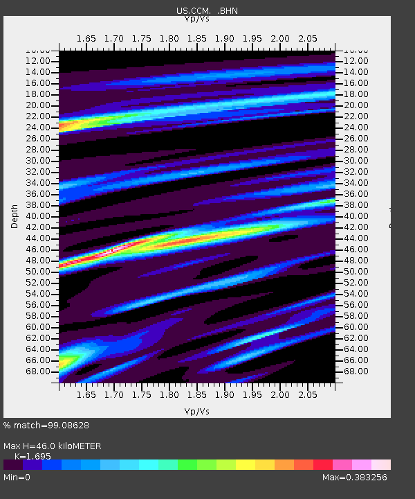
| Estimated Moho Depth: |
46.0 km |
| Estimated Crust Vp/Vs: |
1.70 |
| Assumed Crust Vp: |
6.498 km/s |
| Estimated Crust Vs: |
3.833 km/s |
| Estimated Crust Poisson's Ratio: |
0.23 |
|
| Radial Match: |
99.08628 % |
| Radial Bump: |
239 |
| Transverse Match: |
96.86736 % |
| Transverse Bump: |
400 |
| SOD ConfigId: |
110177 |
| Insert Time: |
2010-03-05 06:51:21.462 +0000 |
| GWidth: |
2.5 |
| Max Bumps: |
400 |
| Tol: |
0.001 |
|

Signal To Noise
| Channel | StoN | STA | LTA |
| US:CCM: :BHN:20030925T20:02:12.63301Z | 2.6894052 | 4.5571676E-7 | 1.694489E-7 |
| US:CCM: :BHE:20030925T20:02:12.63301Z | 2.252547 | 3.8996055E-7 | 1.7311983E-7 |
| US:CCM: :BHZ:20030925T20:02:12.63301Z | 7.6105294 | 1.6619505E-6 | 2.1837515E-7 |
| Arrivals |
| Ps | 5.0 SECOND |
| PpPs | 19 SECOND |
| PsPs/PpSs | 24 SECOND |


