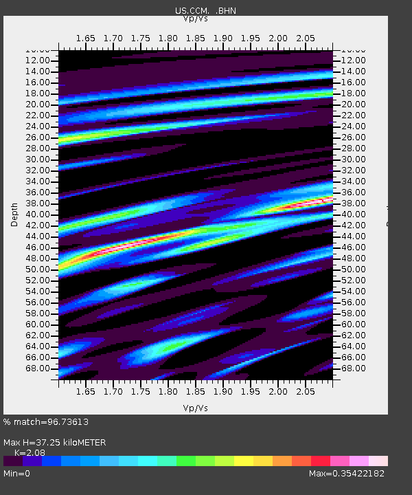
CCM Cathedral Cave, Missouri, USA - Earthquake Result Viewer
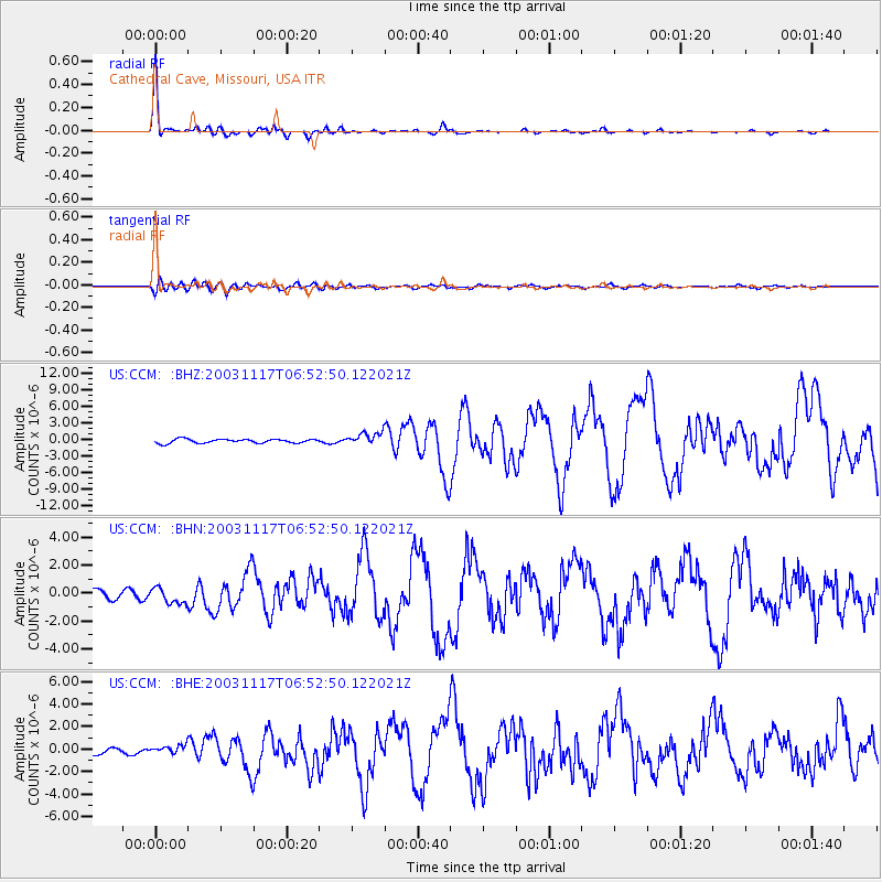
Earthquake location: Rat Islands, Aleutian Islands
Earthquake latitude/longitude: 51.1/178.6
Earthquake time(UTC): 2003/11/17 (321) 06:43:06 GMT
Earthquake Depth: 33 km
Earthquake Magnitude: 6.2 MB, 7.2 MS, 7.8 MW, 7.7 MW
Earthquake Catalog/Contributor: WHDF/NEIC
Network: US United States National Seismic Network
Station: CCM Cathedral Cave, Missouri, USA
Lat/Lon: 38.06 N/91.24 W
Elevation: 222 m
Distance: 61.6 deg
Az: 63.838 deg
Baz: 314.26 deg
Ray Param: 0.060726482
Estimated Moho Depth: 37.25 km
Estimated Crust Vp/Vs: 2.08
Assumed Crust Vp: 6.498 km/s
Estimated Crust Vs: 3.124 km/s
Estimated Crust Poisson's Ratio: 0.35
Radial Match: 96.73613 %
Radial Bump: 213
Transverse Match: 82.548515 %
Transverse Bump: 400
SOD ConfigId: 110177
Insert Time: 2010-03-05 06:51:24.226 +0000
GWidth: 2.5
Max Bumps: 400
Tol: 0.001

Signal To Noise

ChannelStoNSTALTA
US:CCM: :BHN:20031117T06:52:50.122021Z1.62634375.6210007E-73.4562194E-7
US:CCM: :BHE:20031117T06:52:50.122021Z1.43519883.6316285E-72.530401E-7
US:CCM: :BHZ:20031117T06:52:50.122021Z3.1710131.1371179E-63.5859767E-7
Arrivals
Ps6.4 SECOND
PpPs17 SECOND
PsPs/PpSs23 SECOND