You are here: Home > Network List > US - United States National Seismic Network Stations List
> Station CCM Cathedral Cave, Missouri, USA > Earthquake Result Viewer
CCM Cathedral Cave, Missouri, USA - Earthquake Result Viewer
| Earthquake location: |
Komandorskiye Ostrova Region |
| Earthquake latitude/longitude: |
55.5/165.8 |
| Earthquake time(UTC): |
2003/12/05 (339) 21:26:09 GMT |
| Earthquake Depth: |
10 km |
| Earthquake Magnitude: |
6.1 MB, 6.5 MS, 6.7 MW, 6.7 MW |
| Earthquake Catalog/Contributor: |
WHDF/NEIC |
|
| Network: |
US United States National Seismic Network |
| Station: |
CCM Cathedral Cave, Missouri, USA |
| Lat/Lon: |
38.06 N/91.24 W |
| Elevation: |
222 m |
|
| Distance: |
66.2 deg |
| Az: |
57.252 deg |
| Baz: |
322.726 deg |
| Ray Param: |
0.05780214 |
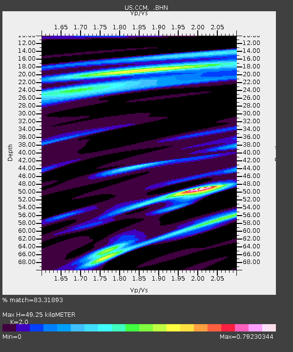
| Estimated Moho Depth: |
49.25 km |
| Estimated Crust Vp/Vs: |
2.00 |
| Assumed Crust Vp: |
6.498 km/s |
| Estimated Crust Vs: |
3.249 km/s |
| Estimated Crust Poisson's Ratio: |
0.33 |
|
| Radial Match: |
83.31893 % |
| Radial Bump: |
324 |
| Transverse Match: |
63.818417 % |
| Transverse Bump: |
400 |
| SOD ConfigId: |
110177 |
| Insert Time: |
2010-03-05 06:51:26.058 +0000 |
| GWidth: |
2.5 |
| Max Bumps: |
400 |
| Tol: |
0.001 |
|
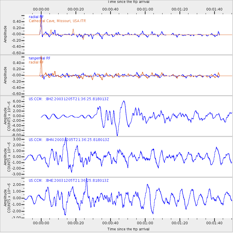
Signal To Noise
| Channel | StoN | STA | LTA |
| US:CCM: :BHN:20031205T21:36:25.818013Z | 2.3125234 | 8.632654E-7 | 3.733002E-7 |
| US:CCM: :BHE:20031205T21:36:25.818013Z | 1.1863426 | 7.6951045E-7 | 6.4864105E-7 |
| US:CCM: :BHZ:20031205T21:36:25.818013Z | 4.4589934 | 2.2045774E-6 | 4.944115E-7 |
| Arrivals |
| Ps | 7.9 SECOND |
| PpPs | 22 SECOND |
| PsPs/PpSs | 30 SECOND |


