You are here: Home > Network List > US - United States National Seismic Network Stations List
> Station REDW Red Top Meadow, Wyoming, USA > Earthquake Result Viewer
REDW Red Top Meadow, Wyoming, USA - Earthquake Result Viewer
| Earthquake location: |
Southern Bolivia |
| Earthquake latitude/longitude: |
-21.1/-65.6 |
| Earthquake time(UTC): |
2004/03/17 (077) 03:21:07 GMT |
| Earthquake Depth: |
290 km |
| Earthquake Magnitude: |
5.5 MB, 6.1 MW, 6.1 MW |
| Earthquake Catalog/Contributor: |
WHDF/NEIC |
|
| Network: |
US United States National Seismic Network |
| Station: |
REDW Red Top Meadow, Wyoming, USA |
| Lat/Lon: |
43.36 N/110.85 W |
| Elevation: |
2192 m |
|
| Distance: |
76.5 deg |
| Az: |
327.797 deg |
| Baz: |
136.983 deg |
| Ray Param: |
0.050191578 |
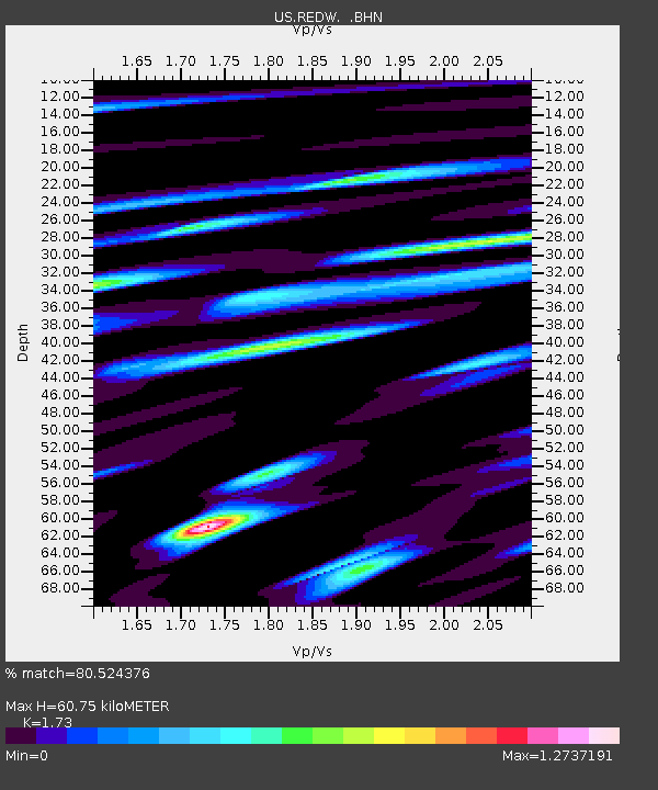
| Estimated Moho Depth: |
60.75 km |
| Estimated Crust Vp/Vs: |
1.73 |
| Assumed Crust Vp: |
6.207 km/s |
| Estimated Crust Vs: |
3.588 km/s |
| Estimated Crust Poisson's Ratio: |
0.25 |
|
| Radial Match: |
80.524376 % |
| Radial Bump: |
400 |
| Transverse Match: |
68.88299 % |
| Transverse Bump: |
400 |
| SOD ConfigId: |
110177 |
| Insert Time: |
2010-03-05 06:51:31.782 +0000 |
| GWidth: |
2.5 |
| Max Bumps: |
400 |
| Tol: |
0.001 |
|

Signal To Noise
| Channel | StoN | STA | LTA |
| US:REDW: :BHN:20040317T03:31:54.915005Z | 4.2167296 | 1.4082083E-6 | 3.3395747E-7 |
| US:REDW: :BHE:20040317T03:31:54.915005Z | 3.9012039 | 1.0911241E-6 | 2.796891E-7 |
| US:REDW: :BHZ:20040317T03:31:54.915005Z | 21.784796 | 2.6771188E-6 | 1.2288932E-7 |
| Arrivals |
| Ps | 7.4 SECOND |
| PpPs | 26 SECOND |
| PsPs/PpSs | 33 SECOND |


