
Station US REDW - Red Top Meadow, Wyoming, USA
Network: US - United States National Seismic Network
Nearby stations (2 deg radius)
| Station | Name | (Lat, Lon) | Start / End | Elevation |
| REDW | Red Top Meadow, Wyoming, USA | (43.36, -110.85) | 2003-07-30 / 2499-01-01 | 2192 m |
| Crust2 Type: | M8,thick extended crust, 1.5 km seds. |
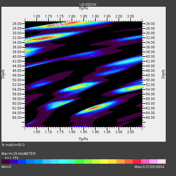
| Thickness Estimate: | 26 km |
| Thickness StdDev: | 13 km |
| Vp/Vs Estimate: | 1.75 |
| Vp/Vs StdDev: | 0.15 |
| Vs Estimate: | 3.537 km/s |
| Poisson's Ratio: | 0.26 |
| Peak Value: | 0.02 |
| Assumed Vp: | 6.207 km/s |
| Ps Weight: | 0.33333334 |
| PpPs Weight: | 0.33333334 |
| PsPs Weight: | 0.33333328 |
| Residual Complexity: | 0.826 |
| Nearby stations H: | 27 km +- 1.4 km |
| (2.0 deg) Vp/Vs: | 1.69 +- 0.08 |
2 with match > 90% ( 20.0 %) and 10 with match > 80% ( 100.0 %) out of 10.
Download stack as xyz text file.
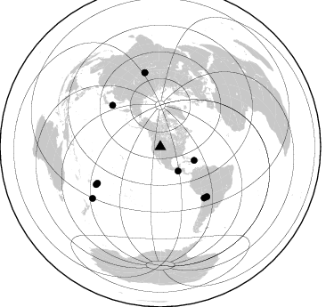
Azimuth Distribution of Events:
Prior Results for this Station
| Study | Thickness | Vp/Vs | Vp | Vs | Poissons Ratio | Extra |
| EARS | 26 km | 1.75 | 6.207 km/s | 3.537 km/s | 0.26 | |
| Crust2.0 | 37 km | 1.78 | 6.207 km/s | 3.489 km/s | 0.27 | M8,thick extended crust, 1.5 km seds. |
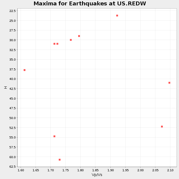
| Global Maxima | 26 km | 1.75 | 6.207 km/s | 3.537 km/s | 0.26 | amp=0.016918804 |
| Local Maxima 1 | 32 km | 1.68 | 6.207 km/s | 3.689 km/s | 0.23 | amp=0.014303014 |
| Local Maxima 2 | 62 km | 1.89 | 6.207 km/s | 3.28 km/s | 0.31 | amp=0.014027332 |
| Local Maxima 3 | 53 km | 1.83 | 6.207 km/s | 3.401 km/s | 0.29 | amp=0.011996821 |
| Local Maxima 4 | 53 km | 2.09 | 6.207 km/s | 2.966 km/s | 0.35 | amp=0.011320975 |
| Predicted Arrivals for vertical incidence (zero ray parameter) | |
| Ps | 3.16 SECOND |
| PpPs | 11.54 SECOND |
| PsPs/PpSs | 14.70 SECOND |
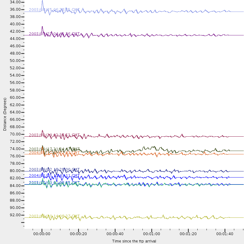
Events Processed for this Station
Download zip of receiver functions as SAC
Plot maxima for each earthquake.
Events Used in the Stack
(10 events)| Radial Match | Distance | Baz | FERegion | Time | Lat/Lon | Depth | Magnitude |
| 93.76094 | 83.3 deg | 239.517 deg | Tonga Islands | 2004/01/25 11:43:11 GMT | (-16.8, -174.2) | 130 km | 6.4 MB, 6.7 MW, 6.7 MW |
| 93.12639 | 41.0 deg | 112.12 deg | Dominican Republic Region | 2003/09/22 04:45:36 GMT | (19.8, -70.7) | 10 km | 6.2 MB, 6.6 MS, 6.5 MW, 6.4 MW |
| 88.46001 | 85.6 deg | 348.055 deg | Southwestern Siberia, Russia | 2003/09/27 11:33:25 GMT | (50.0, 87.8) | 16 km | 6.5 MB, 7.5 MS, 7.3 MW, 7.3 MW |
| 88.13864 | 81.5 deg | 239.856 deg | Tonga Islands | 2003/09/02 18:28:00 GMT | (-15.2, -173.2) | 10 km | 6.0 MB, 6.6 MS, 6.4 MW, 6.3 MW |
| 87.70663 | 71.2 deg | 310.882 deg | Hokkaido, Japan Region | 2003/09/29 02:36:53 GMT | (42.5, 144.4) | 25 km | 6.1 MB, 6.3 MS, 6.5 MW, 6.4 MW |
| 82.49105 | 33.8 deg | 143.816 deg | Guatemala | 2003/08/25 06:28:35 GMT | (14.0, -91.1) | 100 km | 5.4 MB, 5.9 MW, 5.9 MW |
| 81.65152 | 95.4 deg | 232.735 deg | Kermadec Islands, New Zealand | 2003/09/30 14:08:37 GMT | (-30.4, -177.4) | 10 km | 5.8 MB, 6.5 MS, 6.4 MW, 6.4 MW |
| 80.82454 | 85.4 deg | 348.153 deg | Southwestern Siberia, Russia | 2003/10/01 01:03:25 GMT | (50.2, 87.7) | 10 km | 6.3 MB, 7.1 MS, 6.7 MW, 6.7 MW |
| 80.524376 | 76.5 deg | 136.983 deg | Southern Bolivia | 2004/03/17 03:21:07 GMT | (-21.1, -65.6) | 290 km | 5.5 MB, 6.1 MW, 6.1 MW |
| 80.48184 | 75.4 deg | 139.417 deg | Chile-Bolivia Border Region | 2003/09/17 21:34:47 GMT | (-21.5, -68.3) | 127 km | 5.9 MB, 5.8 MW, 5.7 MW |
Losers
(0 events)| Radial Match | Distance | Baz | FERegion | Time | Lat/Lon | Depth | Magnitude | Reason |
