You are here: Home > Network List > US - United States National Seismic Network Stations List
> Station REDW Red Top Meadow, Wyoming, USA > Earthquake Result Viewer
REDW Red Top Meadow, Wyoming, USA - Earthquake Result Viewer
| Earthquake location: |
Hokkaido, Japan Region |
| Earthquake latitude/longitude: |
42.5/144.4 |
| Earthquake time(UTC): |
2003/09/29 (272) 02:36:53 GMT |
| Earthquake Depth: |
25 km |
| Earthquake Magnitude: |
6.1 MB, 6.3 MS, 6.5 MW, 6.4 MW |
| Earthquake Catalog/Contributor: |
WHDF/NEIC |
|
| Network: |
US United States National Seismic Network |
| Station: |
REDW Red Top Meadow, Wyoming, USA |
| Lat/Lon: |
43.36 N/110.85 W |
| Elevation: |
2192 m |
|
| Distance: |
71.2 deg |
| Az: |
48.162 deg |
| Baz: |
310.882 deg |
| Ray Param: |
0.054461326 |
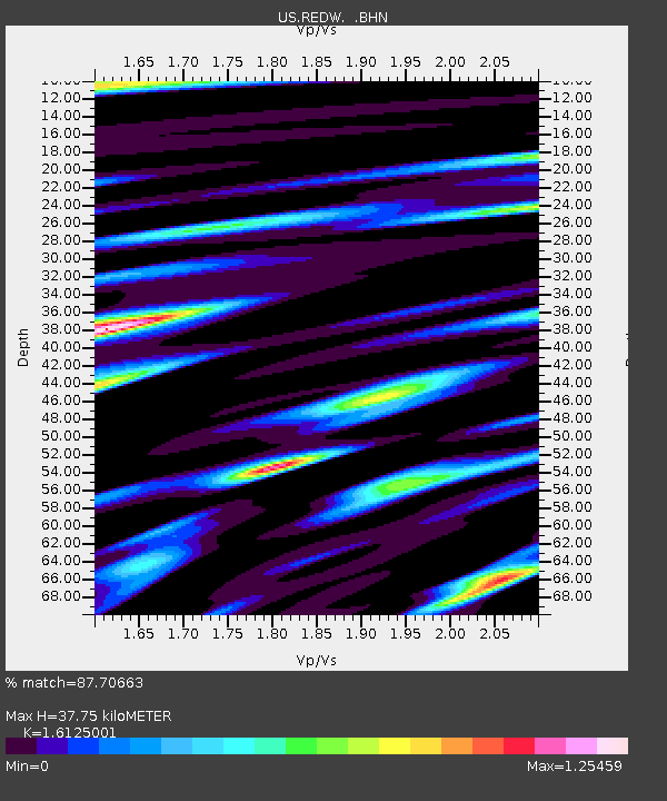
| Estimated Moho Depth: |
37.75 km |
| Estimated Crust Vp/Vs: |
1.61 |
| Assumed Crust Vp: |
6.207 km/s |
| Estimated Crust Vs: |
3.849 km/s |
| Estimated Crust Poisson's Ratio: |
0.19 |
|
| Radial Match: |
87.70663 % |
| Radial Bump: |
400 |
| Transverse Match: |
81.621445 % |
| Transverse Bump: |
400 |
| SOD ConfigId: |
110165 |
| Insert Time: |
2010-03-05 06:51:34.484 +0000 |
| GWidth: |
2.5 |
| Max Bumps: |
400 |
| Tol: |
0.001 |
|

Signal To Noise
| Channel | StoN | STA | LTA |
| US:REDW: :BHN:20030929T02:47:38.613022Z | 2.0157902 | 3.5802915E-7 | 1.776123E-7 |
| US:REDW: :BHE:20030929T02:47:38.613022Z | 2.3387604 | 2.3066383E-7 | 9.8626536E-8 |
| US:REDW: :BHZ:20030929T02:47:38.613022Z | 1.949978 | 2.2180744E-7 | 1.1374869E-7 |
| Arrivals |
| Ps | 3.9 SECOND |
| PpPs | 15 SECOND |
| PsPs/PpSs | 19 SECOND |


