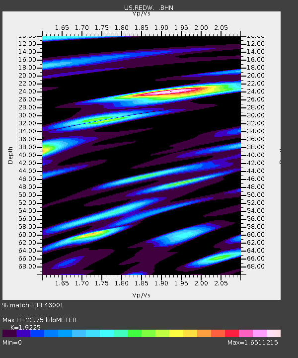
REDW Red Top Meadow, Wyoming, USA - Earthquake Result Viewer
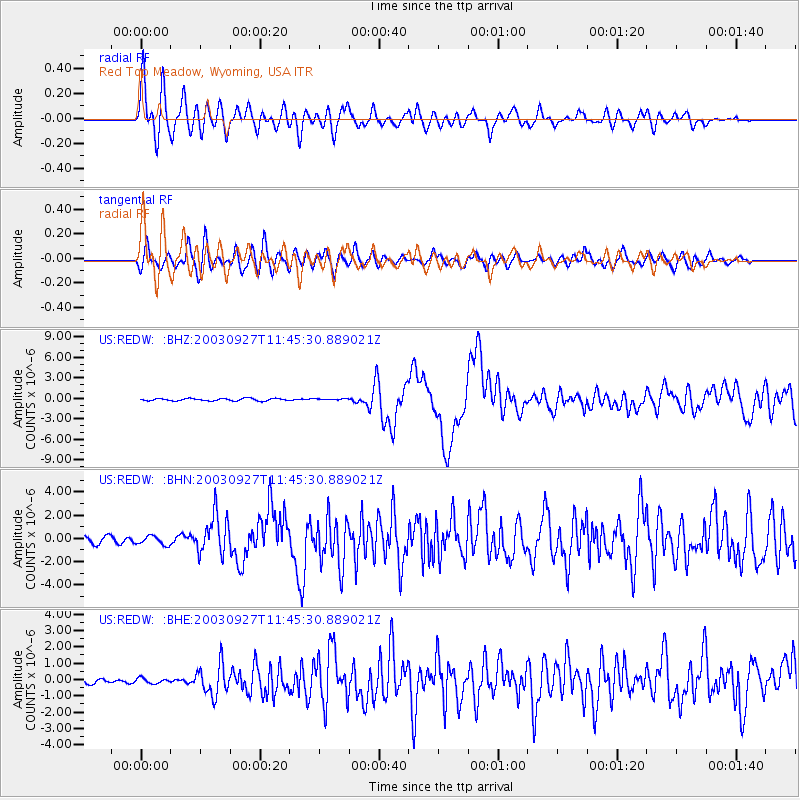
Earthquake location: Southwestern Siberia, Russia
Earthquake latitude/longitude: 50.0/87.8
Earthquake time(UTC): 2003/09/27 (270) 11:33:25 GMT
Earthquake Depth: 16 km
Earthquake Magnitude: 6.5 MB, 7.5 MS, 7.3 MW, 7.3 MW
Earthquake Catalog/Contributor: WHDF/NEIC
Network: US United States National Seismic Network
Station: REDW Red Top Meadow, Wyoming, USA
Lat/Lon: 43.36 N/110.85 W
Elevation: 2192 m
Distance: 85.6 deg
Az: 13.539 deg
Baz: 348.055 deg
Ray Param: 0.044665597
Estimated Moho Depth: 23.75 km
Estimated Crust Vp/Vs: 1.92
Assumed Crust Vp: 6.207 km/s
Estimated Crust Vs: 3.228 km/s
Estimated Crust Poisson's Ratio: 0.31
Radial Match: 88.46001 %
Radial Bump: 400
Transverse Match: 77.48667 %
Transverse Bump: 400
SOD ConfigId: 110165
Insert Time: 2010-03-05 06:51:36.602 +0000
GWidth: 2.5
Max Bumps: 400
Tol: 0.001

Signal To Noise

ChannelStoNSTALTA
US:REDW: :BHN:20030927T11:45:30.889021Z1.35716343.9029885E-72.8758427E-7
US:REDW: :BHE:20030927T11:45:30.889021Z0.57126671.5833055E-72.7715697E-7
US:REDW: :BHZ:20030927T11:45:30.889021Z0.5910631.03719074E-71.7547887E-7
Arrivals
Ps3.6 SECOND
PpPs11 SECOND
PsPs/PpSs15 SECOND