You are here: Home > Network List > US - United States National Seismic Network Stations List
> Station REDW Red Top Meadow, Wyoming, USA > Earthquake Result Viewer
REDW Red Top Meadow, Wyoming, USA - Earthquake Result Viewer
| Earthquake location: |
Tonga Islands |
| Earthquake latitude/longitude: |
-15.2/-173.2 |
| Earthquake time(UTC): |
2003/09/02 (245) 18:28:00 GMT |
| Earthquake Depth: |
10 km |
| Earthquake Magnitude: |
6.0 MB, 6.6 MS, 6.4 MW, 6.3 MW |
| Earthquake Catalog/Contributor: |
WHDF/NEIC |
|
| Network: |
US United States National Seismic Network |
| Station: |
REDW Red Top Meadow, Wyoming, USA |
| Lat/Lon: |
43.36 N/110.85 W |
| Elevation: |
2192 m |
|
| Distance: |
81.5 deg |
| Az: |
40.794 deg |
| Baz: |
239.856 deg |
| Ray Param: |
0.047546558 |
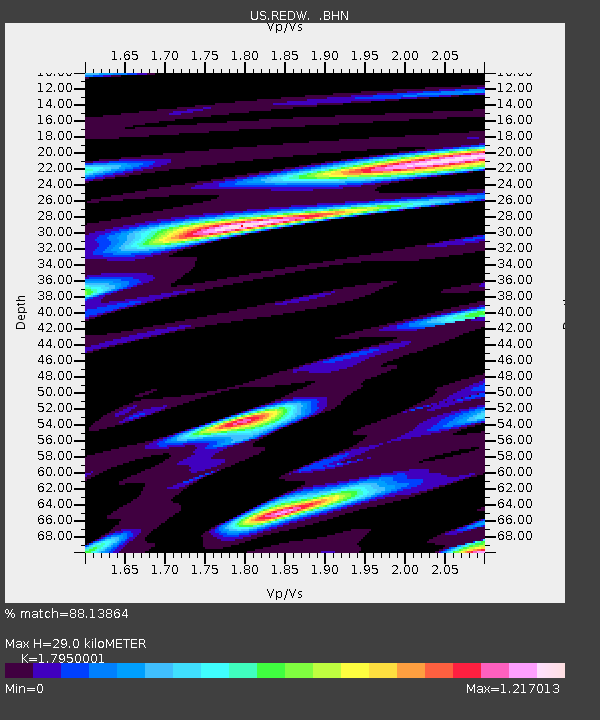
| Estimated Moho Depth: |
29.0 km |
| Estimated Crust Vp/Vs: |
1.80 |
| Assumed Crust Vp: |
6.207 km/s |
| Estimated Crust Vs: |
3.458 km/s |
| Estimated Crust Poisson's Ratio: |
0.27 |
|
| Radial Match: |
88.13864 % |
| Radial Bump: |
400 |
| Transverse Match: |
84.440605 % |
| Transverse Bump: |
400 |
| SOD ConfigId: |
110165 |
| Insert Time: |
2010-03-05 06:51:38.825 +0000 |
| GWidth: |
2.5 |
| Max Bumps: |
400 |
| Tol: |
0.001 |
|

Signal To Noise
| Channel | StoN | STA | LTA |
| US:REDW: :BHN:20030902T18:39:46.314009Z | 0.78122103 | 1.6194984E-7 | 2.0730347E-7 |
| US:REDW: :BHE:20030902T18:39:46.314009Z | 0.68003935 | 1.3812655E-7 | 2.0311552E-7 |
| US:REDW: :BHZ:20030902T18:39:46.314009Z | 2.7612183 | 3.6809476E-7 | 1.3330883E-7 |
| Arrivals |
| Ps | 3.8 SECOND |
| PpPs | 13 SECOND |
| PsPs/PpSs | 17 SECOND |


