You are here: Home > Network List > US - United States National Seismic Network Stations List
> Station REDW Red Top Meadow, Wyoming, USA > Earthquake Result Viewer
REDW Red Top Meadow, Wyoming, USA - Earthquake Result Viewer
| Earthquake location: |
Chile-Bolivia Border Region |
| Earthquake latitude/longitude: |
-21.5/-68.3 |
| Earthquake time(UTC): |
2003/09/17 (260) 21:34:47 GMT |
| Earthquake Depth: |
127 km |
| Earthquake Magnitude: |
5.9 MB, 5.8 MW, 5.7 MW |
| Earthquake Catalog/Contributor: |
WHDF/NEIC |
|
| Network: |
US United States National Seismic Network |
| Station: |
REDW Red Top Meadow, Wyoming, USA |
| Lat/Lon: |
43.36 N/110.85 W |
| Elevation: |
2192 m |
|
| Distance: |
75.4 deg |
| Az: |
329.378 deg |
| Baz: |
139.417 deg |
| Ray Param: |
0.05136761 |
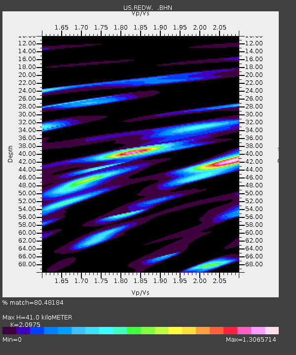
| Estimated Moho Depth: |
41.0 km |
| Estimated Crust Vp/Vs: |
2.10 |
| Assumed Crust Vp: |
6.207 km/s |
| Estimated Crust Vs: |
2.959 km/s |
| Estimated Crust Poisson's Ratio: |
0.35 |
|
| Radial Match: |
80.48184 % |
| Radial Bump: |
400 |
| Transverse Match: |
65.38928 % |
| Transverse Bump: |
400 |
| SOD ConfigId: |
110177 |
| Insert Time: |
2010-03-05 06:51:41.898 +0000 |
| GWidth: |
2.5 |
| Max Bumps: |
400 |
| Tol: |
0.001 |
|

Signal To Noise
| Channel | StoN | STA | LTA |
| US:REDW: :BHN:20030917T21:45:46.089006Z | 2.671534 | 8.702741E-7 | 3.2575818E-7 |
| US:REDW: :BHE:20030917T21:45:46.089006Z | 2.8220859 | 5.047727E-7 | 1.7886511E-7 |
| US:REDW: :BHZ:20030917T21:45:46.089006Z | 13.8542 | 1.5637255E-6 | 1.1287014E-7 |
| Arrivals |
| Ps | 7.4 SECOND |
| PpPs | 20 SECOND |
| PsPs/PpSs | 27 SECOND |


