You are here: Home > Network List > US - United States National Seismic Network Stations List
> Station REDW Red Top Meadow, Wyoming, USA > Earthquake Result Viewer
REDW Red Top Meadow, Wyoming, USA - Earthquake Result Viewer
| Earthquake location: |
Dominican Republic Region |
| Earthquake latitude/longitude: |
19.8/-70.7 |
| Earthquake time(UTC): |
2003/09/22 (265) 04:45:36 GMT |
| Earthquake Depth: |
10 km |
| Earthquake Magnitude: |
6.2 MB, 6.6 MS, 6.5 MW, 6.4 MW |
| Earthquake Catalog/Contributor: |
WHDF/NEIC |
|
| Network: |
US United States National Seismic Network |
| Station: |
REDW Red Top Meadow, Wyoming, USA |
| Lat/Lon: |
43.36 N/110.85 W |
| Elevation: |
2192 m |
|
| Distance: |
41.0 deg |
| Az: |
314.156 deg |
| Baz: |
112.12 deg |
| Ray Param: |
0.074074626 |
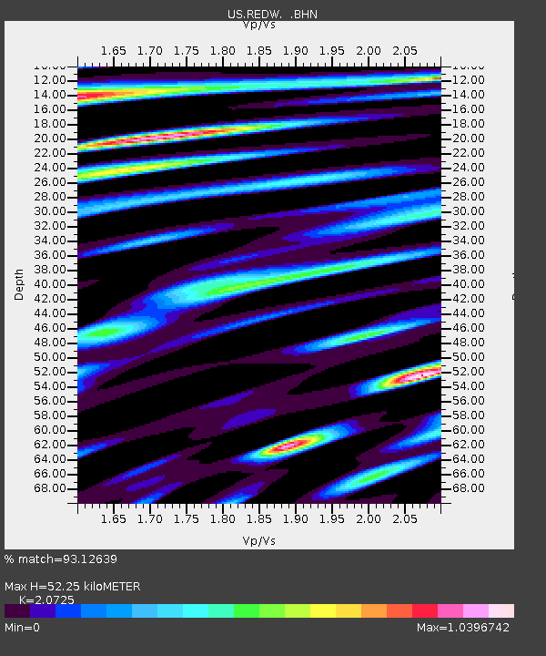
| Estimated Moho Depth: |
52.25 km |
| Estimated Crust Vp/Vs: |
2.07 |
| Assumed Crust Vp: |
6.207 km/s |
| Estimated Crust Vs: |
2.995 km/s |
| Estimated Crust Poisson's Ratio: |
0.35 |
|
| Radial Match: |
93.12639 % |
| Radial Bump: |
400 |
| Transverse Match: |
80.43886 % |
| Transverse Bump: |
400 |
| SOD ConfigId: |
110177 |
| Insert Time: |
2010-03-05 06:51:43.489 +0000 |
| GWidth: |
2.5 |
| Max Bumps: |
400 |
| Tol: |
0.001 |
|

Signal To Noise
| Channel | StoN | STA | LTA |
| US:REDW: :BHN:20030922T04:52:48.340006Z | 0.9269522 | 2.2542113E-7 | 2.431853E-7 |
| US:REDW: :BHE:20030922T04:52:48.340006Z | 1.162244 | 2.3825041E-7 | 2.0499174E-7 |
| US:REDW: :BHZ:20030922T04:52:48.340006Z | 3.2574694 | 4.145405E-7 | 1.2725845E-7 |
| Arrivals |
| Ps | 9.5 SECOND |
| PpPs | 24 SECOND |
| PsPs/PpSs | 34 SECOND |


