You are here: Home > Network List > US - United States National Seismic Network Stations List
> Station SAO San Andreas Geological Observatory, San Benito County, Calif > Earthquake Result Viewer
SAO San Andreas Geological Observatory, San Benito County, Calif - Earthquake Result Viewer
| Earthquake location: |
South Of Kermadec Islands |
| Earthquake latitude/longitude: |
-32.6/-179.4 |
| Earthquake time(UTC): |
2005/05/16 (136) 03:54:14 GMT |
| Earthquake Depth: |
34 km |
| Earthquake Magnitude: |
6.2 MB, 6.4 MS, 6.6 MW, 6.6 MW |
| Earthquake Catalog/Contributor: |
WHDF/NEIC |
|
| Network: |
US United States National Seismic Network |
| Station: |
SAO San Andreas Geological Observatory, San Benito County, Calif |
| Lat/Lon: |
36.76 N/121.44 W |
| Elevation: |
350 m |
|
| Distance: |
87.7 deg |
| Az: |
42.912 deg |
| Baz: |
225.708 deg |
| Ray Param: |
0.04311449 |
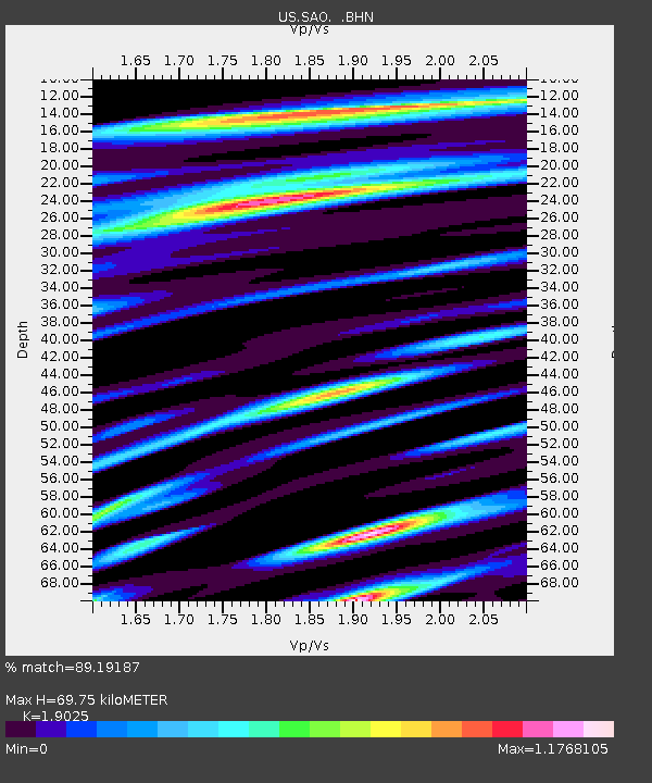
| Estimated Moho Depth: |
69.75 km |
| Estimated Crust Vp/Vs: |
1.90 |
| Assumed Crust Vp: |
6.391 km/s |
| Estimated Crust Vs: |
3.359 km/s |
| Estimated Crust Poisson's Ratio: |
0.31 |
|
| Radial Match: |
89.19187 % |
| Radial Bump: |
400 |
| Transverse Match: |
83.86768 % |
| Transverse Bump: |
400 |
| SOD ConfigId: |
110194 |
| Insert Time: |
2010-03-05 06:51:50.322 +0000 |
| GWidth: |
2.5 |
| Max Bumps: |
400 |
| Tol: |
0.001 |
|

Signal To Noise
| Channel | StoN | STA | LTA |
| US:SAO: :BHN:20050516T04:06:28.408025Z | 3.8173268 | 5.2917034E-7 | 1.3862328E-7 |
| US:SAO: :BHE:20050516T04:06:28.408025Z | 4.2685156 | 5.277409E-7 | 1.236357E-7 |
| US:SAO: :BHZ:20050516T04:06:28.408025Z | 7.980514 | 1.2831637E-6 | 1.607871E-7 |
| Arrivals |
| Ps | 10 SECOND |
| PpPs | 31 SECOND |
| PsPs/PpSs | 41 SECOND |


