
Station US SAO - San Andreas Geological Observatory, San Benito County, Calif
Network: US - United States National Seismic Network
Nearby stations (2 deg radius)
| Station | Name | (Lat, Lon) | Start / End | Elevation |
| SAO | San Andreas Geological Observatory, San Benito County, Calif | (36.76, -121.44) | 1993-03-01 / 2499-01-01 | 350 m |
| Crust2 Type: | T4,Margin /shield transition, East Siberia, 2 km seds. |
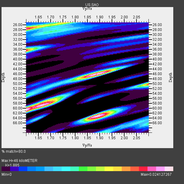
| Thickness Estimate: | 46 km |
| Thickness StdDev: | 14 km |
| Vp/Vs Estimate: | 1.88 |
| Vp/Vs StdDev: | 0.15 |
| Vs Estimate: | 3.39 km/s |
| Poisson's Ratio: | 0.30 |
| Peak Value: | 0.02 |
| Assumed Vp: | 6.391 km/s |
| Ps Weight: | 0.33333334 |
| PpPs Weight: | 0.33333334 |
| PsPs Weight: | 0.33333328 |
| Residual Complexity: | 0.861 |
| Nearby stations H: | 37 km +- 13 km |
| (2.0 deg) Vp/Vs: | 1.74 +- 0.20 |
4 with match > 90% ( 26.666666 %) and 14 with match > 80% ( 93.333336 %) out of 15.
Download stack as xyz text file.
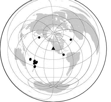
Azimuth Distribution of Events:
Prior Results for this Station
| Study | Thickness | Vp/Vs | Vp | Vs | Poissons Ratio | Extra |
| EARS | 46 km | 1.88 | 6.391 km/s | 3.39 km/s | 0.30 | |
| Crust2.0 | 32 km | 1.79 | 6.391 km/s | 3.572 km/s | 0.27 | T4,Margin /shield transition, East Siberia, 2 km seds. |
| Global Maxima | 46 km | 1.88 | 6.391 km/s | 3.39 km/s | 0.30 | amp=0.024127267 |
| Local Maxima 1 | 60 km | 1.60 | 6.391 km/s | 3.994 km/s | 0.18 | amp=0.023980366 |
| Local Maxima 2 | 63 km | 1.89 | 6.391 km/s | 3.386 km/s | 0.30 | amp=0.023523765 |
| Local Maxima 3 | 28 km | 1.60 | 6.391 km/s | 3.994 km/s | 0.18 | amp=0.021773756 |
| Local Maxima 4 | 36 km | 1.60 | 6.391 km/s | 3.994 km/s | 0.18 | amp=0.019909391 |
| Predicted Arrivals for vertical incidence (zero ray parameter) | |
| Ps | 6.37 SECOND |
| PpPs | 20.77 SECOND |
| PsPs/PpSs | 27.14 SECOND |
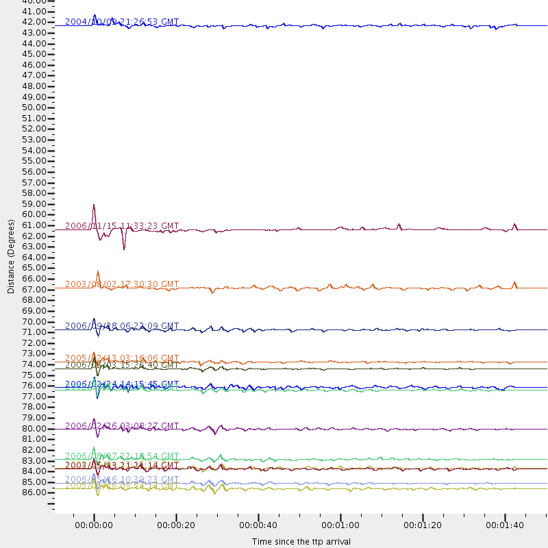
Events Processed for this Station
Download zip of receiver functions as SAC
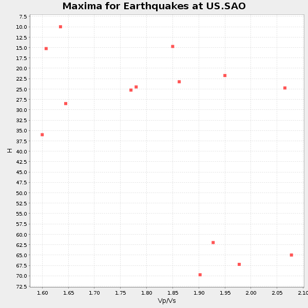
Plot maxima for each earthquake.
Events Used in the Stack
(14 events)| Radial Match | Distance | Baz | FERegion | Time | Lat/Lon | Depth | Magnitude |
| 96.722916 | 75.4 deg | 230.541 deg | Tonga Islands | 2006/05/03 15:26:40 GMT | (-20.2, -174.1) | 55 km | 7.2 MB, 7.8 MS, 7.9 MW, 7.9 MW |
| 93.131195 | 87.1 deg | 226.234 deg | Kermadec Islands Region | 2006/05/16 10:39:23 GMT | (-31.8, -179.3) | 152 km | 6.8 MB, 7.4 MW, 7.4 MW |
| 90.35811 | 84.6 deg | 245.927 deg | Vanuatu Islands | 2006/08/07 22:18:54 GMT | (-15.8, 167.8) | 141 km | 6.0 MB, 6.8 MW, 6.8 MW |
| 90.2408 | 40.2 deg | 119.924 deg | Near Coast Of Nicaragua | 2004/10/09 21:26:53 GMT | (11.4, -86.7) | 35 km | 6.0 MB, 7.0 MS, 6.9 MW, 6.8 MW |
| 89.19187 | 87.7 deg | 225.708 deg | South Of Kermadec Islands | 2005/05/16 03:54:14 GMT | (-32.6, -179.4) | 34 km | 6.2 MB, 6.4 MS, 6.6 MW, 6.6 MW |
| 88.93986 | 71.4 deg | 231.433 deg | Samoa Islands Region | 2006/09/28 06:22:09 GMT | (-16.6, -172.0) | 28 km | 6.5 MB, 6.6 MS, 6.9 MW, 6.7 MW |
| 88.85494 | 77.6 deg | 231.697 deg | Fiji Islands Region | 2003/07/27 02:04:11 GMT | (-21.1, -176.6) | 213 km | 5.9 MB, 6.6 MW, 6.6 MW |
| 88.64696 | 61.1 deg | 308.686 deg | Kuril Islands | 2006/11/15 11:33:23 GMT | (46.9, 153.7) | 10 km | 5.5 MB |
| 85.6449 | 85.5 deg | 226.395 deg | Kermadec Islands, New Zealand | 2003/05/04 13:15:18 GMT | (-30.5, -178.2) | 62 km | 6.0 MB, 6.5 MS, 6.7 MW, 6.7 MW |
| 85.01304 | 81.5 deg | 232.288 deg | South Of Fiji Islands | 2006/02/26 03:08:27 GMT | (-23.6, -180.0) | 535 km | 5.9 MB, 6.4 MW, 6.4 MW |
| 83.69909 | 85.6 deg | 244.815 deg | Vanuatu Islands | 2003/05/13 21:21:14 GMT | (-17.3, 167.7) | 33 km | 6.0 MB, 6.4 MS, 6.3 MW, 6.3 MW |
| 83.150345 | 77.3 deg | 235.967 deg | Fiji Islands Region | 2006/02/24 14:15:45 GMT | (-18.0, -179.6) | 622 km | 5.9 MB, 6.1 MW, 6.0 MW |
| 82.347664 | 67.1 deg | 62.691 deg | Northern Mid-Atlantic Ridge | 2003/08/02 17:30:30 GMT | (35.0, -35.7) | 10 km | 4.8 MB, 5.1 MS, 5.8 MW, 5.7 MW |
| 80.04481 | 74.6 deg | 237.204 deg | Fiji Islands Region | 2005/12/13 03:16:06 GMT | (-15.3, -178.6) | 10 km | 6.1 MB, 6.8 MS, 6.7 MW, 6.7 MW |
Losers
(1 events)| Radial Match | Distance | Baz | FERegion | Time | Lat/Lon | Depth | Magnitude | Reason |
| 91.27921 | 40.7 deg | 119.593 deg | Near Coast Of Nicaragua | 2005/07/02 02:16:43 GMT | (11.2, -86.2) | 27 km | 5.6 MB, 6.4 MS, 6.6 MW, 6.6 MW |
