You are here: Home > Network List > US - United States National Seismic Network Stations List
> Station SAO San Andreas Geological Observatory, San Benito County, Calif > Earthquake Result Viewer
SAO San Andreas Geological Observatory, San Benito County, Calif - Earthquake Result Viewer

| Earthquake location: |
Kuril Islands |
| Earthquake latitude/longitude: |
46.9/153.7 |
| Earthquake time(UTC): |
2006/11/15 (319) 11:33:23 GMT |
| Earthquake Depth: |
10 km |
| Earthquake Magnitude: |
5.5 MB |
| Earthquake Catalog/Contributor: |
WHDF/NEIC |
|
| Network: |
US United States National Seismic Network |
| Station: |
SAO San Andreas Geological Observatory, San Benito County, Calif |
| Lat/Lon: |
36.76 N/121.44 W |
| Elevation: |
350 m |
|
| Distance: |
61.1 deg |
| Az: |
65.989 deg |
| Baz: |
308.686 deg |
| Ray Param: |
0.06109185 |
| Estimated Moho Depth: |
15.25 km |
| Estimated Crust Vp/Vs: |
1.61 |
| Assumed Crust Vp: |
6.391 km/s |
| Estimated Crust Vs: |
3.976 km/s |
| Estimated Crust Poisson's Ratio: |
0.18 |
|
| Radial Match: |
88.64696 % |
| Radial Bump: |
400 |
| Transverse Match: |
57.69313 % |
| Transverse Bump: |
400 |
| SOD ConfigId: |
2564 |
| Insert Time: |
2010-03-05 06:51:51.939 +0000 |
| GWidth: |
2.5 |
| Max Bumps: |
400 |
| Tol: |
0.001 |
|
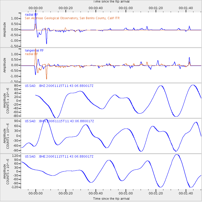
Signal To Noise
| Channel | StoN | STA | LTA |
| US:SAO: :BHN:20061115T11:43:06.880017Z | 1.0118725 | 4.6591267E-5 | 4.6044603E-5 |
| US:SAO: :BHE:20061115T11:43:06.880017Z | 0.2067365 | 1.6678216E-5 | 8.067378E-5 |
| US:SAO: :BHZ:20061115T11:43:06.880017Z | 1.2340777 | 5.421754E-5 | 4.393365E-5 |
| Arrivals |
| Ps | 1.5 SECOND |
| PpPs | 5.9 SECOND |
| PsPs/PpSs | 7.4 SECOND |


