You are here: Home > Network List > US - United States National Seismic Network Stations List
> Station SAO San Andreas Geological Observatory, San Benito County, Calif > Earthquake Result Viewer
SAO San Andreas Geological Observatory, San Benito County, Calif - Earthquake Result Viewer
| Earthquake location: |
Northern Mid-Atlantic Ridge |
| Earthquake latitude/longitude: |
35.0/-35.7 |
| Earthquake time(UTC): |
2003/08/02 (214) 17:30:30 GMT |
| Earthquake Depth: |
10 km |
| Earthquake Magnitude: |
4.8 MB, 5.1 MS, 5.8 MW, 5.7 MW |
| Earthquake Catalog/Contributor: |
WHDF/NEIC |
|
| Network: |
US United States National Seismic Network |
| Station: |
SAO San Andreas Geological Observatory, San Benito County, Calif |
| Lat/Lon: |
36.76 N/121.44 W |
| Elevation: |
350 m |
|
| Distance: |
67.1 deg |
| Az: |
299.605 deg |
| Baz: |
62.691 deg |
| Ray Param: |
0.057190612 |
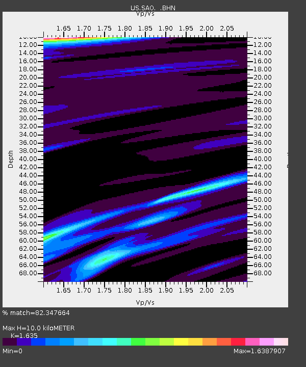
| Estimated Moho Depth: |
10.0 km |
| Estimated Crust Vp/Vs: |
1.63 |
| Assumed Crust Vp: |
6.391 km/s |
| Estimated Crust Vs: |
3.909 km/s |
| Estimated Crust Poisson's Ratio: |
0.20 |
|
| Radial Match: |
82.347664 % |
| Radial Bump: |
355 |
| Transverse Match: |
67.28833 % |
| Transverse Bump: |
400 |
| SOD ConfigId: |
110165 |
| Insert Time: |
2010-03-05 06:52:03.165 +0000 |
| GWidth: |
2.5 |
| Max Bumps: |
400 |
| Tol: |
0.001 |
|
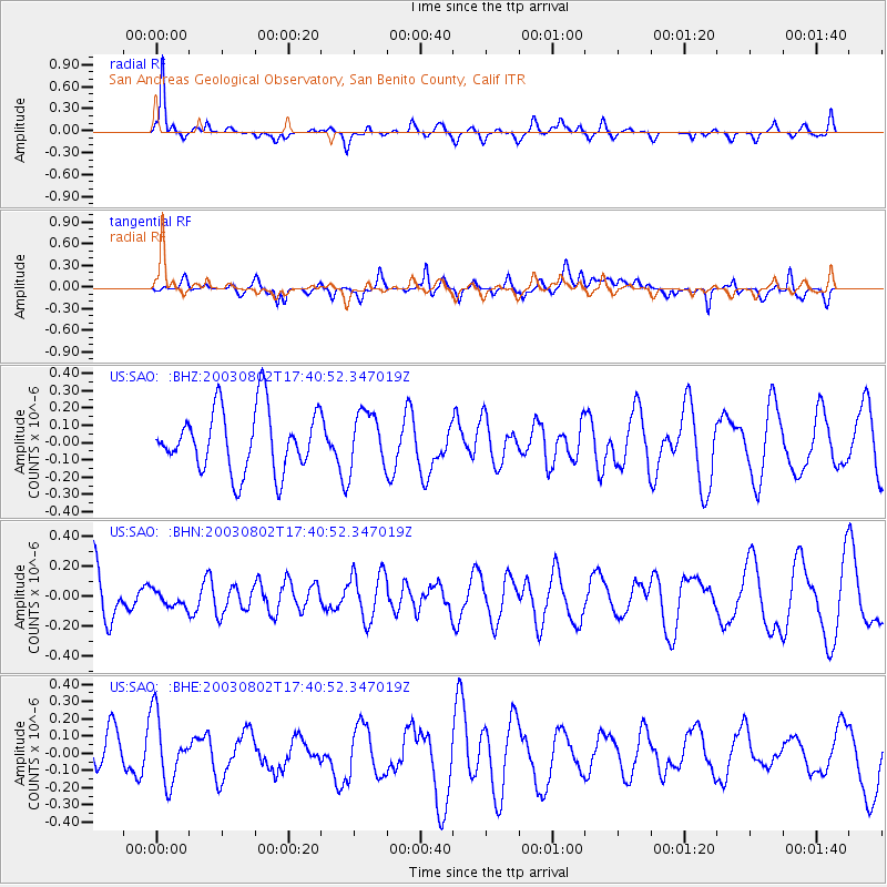
Signal To Noise
| Channel | StoN | STA | LTA |
| US:SAO: :BHN:20030802T17:40:52.347019Z | 0.28452748 | 6.607206E-8 | 2.3221679E-7 |
| US:SAO: :BHE:20030802T17:40:52.347019Z | 1.079939 | 2.0073165E-7 | 1.8587312E-7 |
| US:SAO: :BHZ:20030802T17:40:52.347019Z | 0.9032992 | 1.6119905E-7 | 1.7845588E-7 |
| Arrivals |
| Ps | 1.0 SECOND |
| PpPs | 4.0 SECOND |
| PsPs/PpSs | 5.0 SECOND |


