You are here: Home > Network List > US - United States National Seismic Network Stations List
> Station SAO San Andreas Geological Observatory, San Benito County, Calif > Earthquake Result Viewer
SAO San Andreas Geological Observatory, San Benito County, Calif - Earthquake Result Viewer
| Earthquake location: |
Fiji Islands Region |
| Earthquake latitude/longitude: |
-21.1/-176.6 |
| Earthquake time(UTC): |
2003/07/27 (208) 02:04:11 GMT |
| Earthquake Depth: |
213 km |
| Earthquake Magnitude: |
5.9 MB, 6.6 MW, 6.6 MW |
| Earthquake Catalog/Contributor: |
WHDF/NEIC |
|
| Network: |
US United States National Seismic Network |
| Station: |
SAO San Andreas Geological Observatory, San Benito County, Calif |
| Lat/Lon: |
36.76 N/121.44 W |
| Elevation: |
350 m |
|
| Distance: |
77.6 deg |
| Az: |
42.437 deg |
| Baz: |
231.697 deg |
| Ray Param: |
0.04969266 |
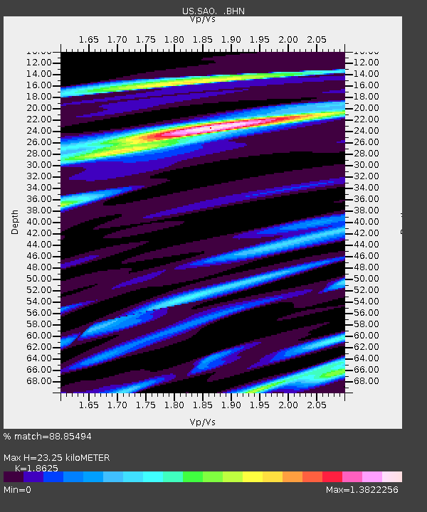
| Estimated Moho Depth: |
23.25 km |
| Estimated Crust Vp/Vs: |
1.86 |
| Assumed Crust Vp: |
6.391 km/s |
| Estimated Crust Vs: |
3.431 km/s |
| Estimated Crust Poisson's Ratio: |
0.30 |
|
| Radial Match: |
88.85494 % |
| Radial Bump: |
400 |
| Transverse Match: |
83.00795 % |
| Transverse Bump: |
400 |
| SOD ConfigId: |
110177 |
| Insert Time: |
2010-03-05 06:52:08.182 +0000 |
| GWidth: |
2.5 |
| Max Bumps: |
400 |
| Tol: |
0.001 |
|

Signal To Noise
| Channel | StoN | STA | LTA |
| US:SAO: :BHN:20030727T02:15:12.647004Z | 3.4808052 | 6.2660087E-7 | 1.8001607E-7 |
| US:SAO: :BHE:20030727T02:15:12.647004Z | 3.4513345 | 6.7522967E-7 | 1.9564305E-7 |
| US:SAO: :BHZ:20030727T02:15:12.647004Z | 5.4051256 | 1.2547426E-6 | 2.3213941E-7 |
| Arrivals |
| Ps | 3.2 SECOND |
| PpPs | 10 SECOND |
| PsPs/PpSs | 13 SECOND |


