You are here: Home > Network List > US - United States National Seismic Network Stations List
> Station OCWA Octopus Mountain, Washington, USA > Earthquake Result Viewer
OCWA Octopus Mountain, Washington, USA - Earthquake Result Viewer
| Earthquake location: |
Honduras |
| Earthquake latitude/longitude: |
15.8/-88.3 |
| Earthquake time(UTC): |
1999/07/11 (192) 14:14:16 GMT |
| Earthquake Depth: |
10 km |
| Earthquake Magnitude: |
6.0 MB, 6.6 MS, 6.7 MW, 6.3 ME |
| Earthquake Catalog/Contributor: |
WHDF/NEIC |
|
| Network: |
US United States National Seismic Network |
| Station: |
OCWA Octopus Mountain, Washington, USA |
| Lat/Lon: |
47.75 N/124.18 W |
| Elevation: |
671 m |
|
| Distance: |
43.4 deg |
| Az: |
324.914 deg |
| Baz: |
124.91 deg |
| Ray Param: |
0.07255248 |
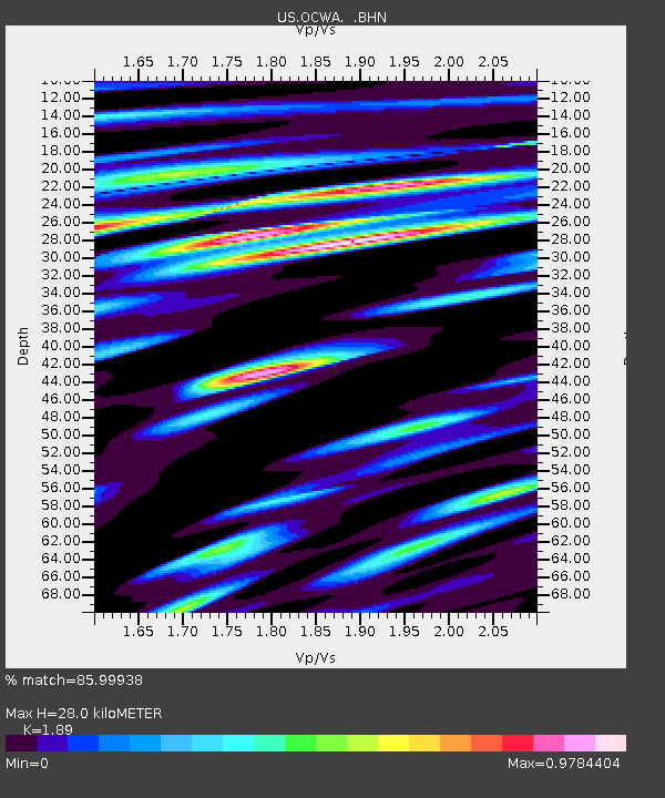
| Estimated Moho Depth: |
28.0 km |
| Estimated Crust Vp/Vs: |
1.89 |
| Assumed Crust Vp: |
6.134 km/s |
| Estimated Crust Vs: |
3.245 km/s |
| Estimated Crust Poisson's Ratio: |
0.31 |
|
| Radial Match: |
85.99938 % |
| Radial Bump: |
400 |
| Transverse Match: |
75.615005 % |
| Transverse Bump: |
400 |
| SOD ConfigId: |
110177 |
| Insert Time: |
2010-03-05 06:55:02.358 +0000 |
| GWidth: |
2.5 |
| Max Bumps: |
400 |
| Tol: |
0.001 |
|

Signal To Noise
| Channel | StoN | STA | LTA |
| US:OCWA: :BHN:19990711T14:21:48.614015Z | 0.8156888 | 2.8064733E-7 | 3.4406176E-7 |
| US:OCWA: :BHE:19990711T14:21:48.614015Z | 1.1885395 | 2.8789503E-7 | 2.422259E-7 |
| US:OCWA: :BHZ:19990711T14:21:48.614015Z | 3.6325016 | 9.99767E-7 | 2.7522825E-7 |
| Arrivals |
| Ps | 4.3 SECOND |
| PpPs | 12 SECOND |
| PsPs/PpSs | 17 SECOND |


