
Station US OCWA - Octopus Mountain, Washington, USA
Network: US - United States National Seismic Network
Nearby stations (2 deg radius)
| Station | Name | (Lat, Lon) | Start / End | Elevation |
| OCWA | Octopus Mountain, Washington, USA | (47.75, -124.18) | 1998-08-28 / 2499-01-01 | 671 m |
| Crust2 Type: | C3,continental shelf, 2 km seds. |
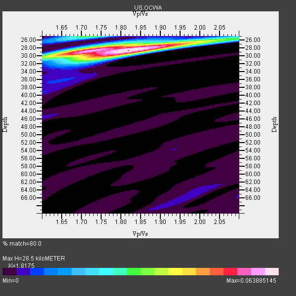
| Thickness Estimate: | 28 km |
| Thickness StdDev: | 0.3 km |
| Vp/Vs Estimate: | 1.82 |
| Vp/Vs StdDev: | 0.05 |
| Vs Estimate: | 3.375 km/s |
| Poisson's Ratio: | 0.28 |
| Peak Value: | 0.06 |
| Assumed Vp: | 6.134 km/s |
| Ps Weight: | 0.33333334 |
| PpPs Weight: | 0.33333334 |
| PsPs Weight: | 0.33333328 |
| Residual Complexity: | 0.490 |
| Nearby stations H: | +- |
| (2.0 deg) Vp/Vs: | +- |
12 with match > 90% ( 41.37931 %) and 28 with match > 80% ( 96.55173 %) out of 29.
Download stack as xyz text file.
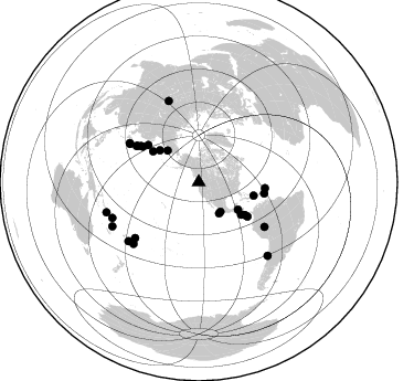
Azimuth Distribution of Events:
Prior Results for this Station
| Study | Thickness | Vp/Vs | Vp | Vs | Poissons Ratio | Extra |
| EARS | 28 km | 1.82 | 6.134 km/s | 3.375 km/s | 0.28 | |
| Crust2.0 | 31 km | 1.80 | 6.134 km/s | 3.406 km/s | 0.28 | C3,continental shelf, 2 km seds. |
| Global Maxima | 28 km | 1.82 | 6.134 km/s | 3.375 km/s | 0.28 | amp=0.063885145 |
| Local Maxima 1 | 28 km | 1.72 | 6.134 km/s | 3.571 km/s | 0.24 | amp=0.04639666 |
| Local Maxima 2 | 25 km | 1.70 | 6.134 km/s | 3.613 km/s | 0.23 | amp=0.027102176 |
| Local Maxima 3 | 30 km | 1.78 | 6.134 km/s | 3.451 km/s | 0.27 | amp=0.018286629 |
| Local Maxima 4 | 26 km | 2.03 | 6.134 km/s | 3.029 km/s | 0.34 | amp=0.008645353 |
| Predicted Arrivals for vertical incidence (zero ray parameter) | |
| Ps | 3.80 SECOND |
| PpPs | 13.09 SECOND |
| PsPs/PpSs | 16.89 SECOND |
Events Processed for this Station
Download zip of receiver functions as SAC
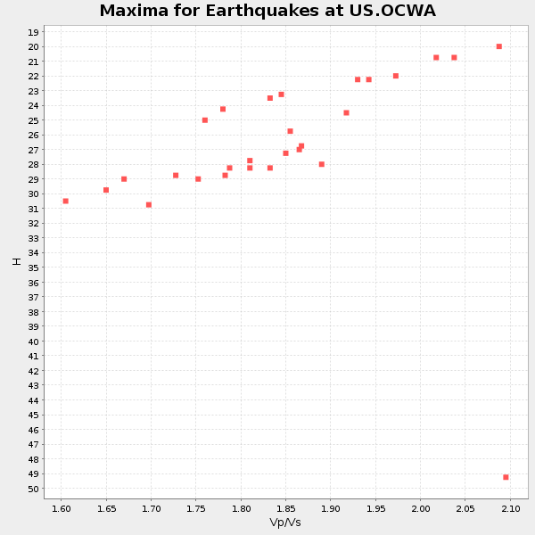
Plot maxima for each earthquake.
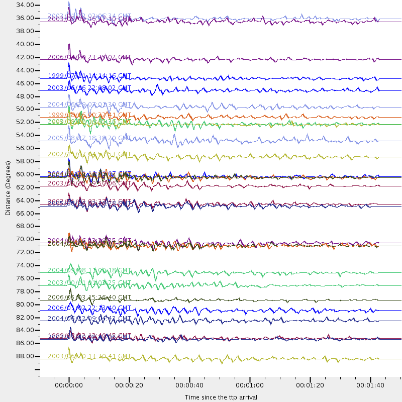
Events Used in the Stack
(28 events)| Radial Match | Distance | Baz | FERegion | Time | Lat/Lon | Depth | Magnitude |
| 96.7064 | 61.7 deg | 301.99 deg | Hokkaido, Japan Region | 2003/09/25 19:50:06 GMT | (41.8, 143.9) | 27 km | 6.9 MB, 8.1 MS, 8.3 MW, 8.1 MW |
| 96.39629 | 81.1 deg | 226.698 deg | Tonga Islands | 2006/05/03 15:26:40 GMT | (-20.2, -174.1) | 55 km | 7.2 MB, 7.8 MS, 7.9 MW, 7.9 MW |
| 94.98231 | 60.3 deg | 95.288 deg | North Atlantic Ocean | 2003/05/14 06:03:35 GMT | (18.3, -58.6) | 42 km | 6.5 MB, 6.5 MS, 6.6 MW, 6.6 MW |
| 94.82362 | 60.1 deg | 99.783 deg | Leeward Islands | 2004/11/21 11:41:07 GMT | (15.7, -61.7) | 14 km | 6.3 MB, 6.1 MS, 6.3 MW, 6.3 MW |
| 94.570305 | 51.2 deg | 103.827 deg | Dominican Republic Region | 2003/09/22 04:45:36 GMT | (19.8, -70.7) | 10 km | 6.2 MB, 6.6 MS, 6.5 MW, 6.4 MW |
| 93.94745 | 87.8 deg | 251.97 deg | Solomon Islands | 2003/01/20 08:43:06 GMT | (-10.5, 160.8) | 33 km | 6.7 MB, 7.8 MS, 7.3 MW, 7.2 MW |
| 93.90433 | 71.5 deg | 299.042 deg | Near S. Coast Of Honshu, Japan | 2004/09/06 23:29:35 GMT | (33.2, 137.2) | 10 km | 6.4 MB, 6.3 MS, 6.7 MW, 6.5 MW |
| 93.482735 | 51.3 deg | 125.486 deg | Costa Rica | 1999/08/20 10:02:21 GMT | (9.0, -84.2) | 20 km | 6.1 MB, 6.9 MS, 7.0 MW, 6.1 ML |
| 92.98604 | 71.9 deg | 299.325 deg | Near S. Coast Of Western Honshu | 2004/09/05 10:07:07 GMT | (33.1, 136.6) | 14 km | 6.7 MB, 7.0 MS, 7.2 MW, 7.0 MW |
| 92.38367 | 33.2 deg | 143.586 deg | Near Coast Of Jalisco, Mexico | 2003/01/22 02:06:34 GMT | (18.8, -104.1) | 24 km | 6.5 MB, 7.6 MS, 7.6 MW, 7.4 MW |
| 92.14253 | 87.6 deg | 242.949 deg | Vanuatu Islands | 1999/08/22 12:40:45 GMT | (-16.1, 168.0) | 33 km | 6.3 MB, 6.2 MS, 6.5 MW, 6.5 MW |
| 91.62696 | 71.9 deg | 124.217 deg | Western Brazil | 2003/06/20 06:19:38 GMT | (-7.6, -71.7) | 558 km | 6.4 MB, 7.1 MW, 7.0 MW |
| 89.75851 | 65.2 deg | 300.066 deg | Near East Coast Of Honshu, Japan | 2005/08/16 02:46:28 GMT | (38.3, 142.0) | 36 km | 6.5 MB, 6.8 MS, 7.2 MW, 7.1 MW |
| 89.59104 | 60.3 deg | 302.388 deg | Hokkaido, Japan Region | 2004/11/28 18:32:14 GMT | (43.0, 145.1) | 39 km | 6.4 MB, 6.7 MS, 7.0 MW, 7.0 MW |
| 88.977776 | 40.2 deg | 315.221 deg | Eastern Siberia, Russia | 2006/04/20 23:25:02 GMT | (60.9, 167.1) | 22 km | 6.8 MB, 7.6 MS, 7.6 MW, 7.3 MW |
| 88.881676 | 64.8 deg | 300.602 deg | Near East Coast Of Honshu, Japan | 2002/11/03 03:37:42 GMT | (38.9, 142.0) | 39 km | 5.7 MB, 6.1 MS, 6.4 MW, 6.4 MW |
| 87.66942 | 76.5 deg | 228.799 deg | Tonga Islands | 2004/09/08 11:00:18 GMT | (-15.2, -173.4) | 13 km | 5.6 MB, 5.6 MS, 5.9 MW, 5.8 MW |
| 85.99938 | 43.4 deg | 124.91 deg | Honduras | 1999/07/11 14:14:16 GMT | (15.8, -88.3) | 10 km | 6.0 MB, 6.6 MS, 6.7 MW, 6.3 ME |
| 85.918755 | 48.3 deg | 127.377 deg | Off Coast Of Costa Rica | 2004/06/29 07:01:30 GMT | (10.7, -87.0) | 9.0 km | 5.8 MB, 5.8 MS, 6.3 MW, 6.1 MW |
| 85.386986 | 82.9 deg | 230.087 deg | Fiji Islands Region | 2006/01/02 22:13:40 GMT | (-19.9, -178.2) | 583 km | 6.5 MB, 7.2 MW, 7.1 MW |
| 85.27507 | 33.8 deg | 146.636 deg | Off Coast Of Jalisco, Mexico | 2003/05/19 16:27:10 GMT | (17.5, -105.5) | 10 km | 5.6 MB, 5.8 MS, 6.2 MW, 6.1 MW |
| 85.220955 | 91.1 deg | 136.803 deg | Near Coast Of Central Chile | 2003/06/20 13:30:41 GMT | (-30.6, -71.6) | 33 km | 6.4 MB, 6.8 MS, 6.8 MW, 6.7 MW |
| 84.454865 | 78.6 deg | 339.737 deg | Southwestern Siberia, Russia | 2003/10/01 01:03:25 GMT | (50.2, 87.7) | 10 km | 6.3 MB, 7.1 MS, 6.7 MW, 6.7 MW |
| 84.44186 | 56.7 deg | 306.313 deg | Northwest Of Kuril Islands | 2002/11/17 04:53:53 GMT | (47.8, 146.2) | 459 km | 7.3 MW, 7.3 MW |
| 83.70217 | 54.1 deg | 125.244 deg | South Of Panama | 2005/08/27 18:38:20 GMT | (6.8, -82.4) | 10 km | 5.6 MB, 5.6 MS, 6.2 MW, 6.1 MW |
| 81.16436 | 84.7 deg | 247.571 deg | Santa Cruz Islands | 2004/06/22 09:04:43 GMT | (-10.9, 166.3) | 153 km | 5.8 MB, 5.9 MW, 5.8 MW |
| 81.01961 | 45.5 deg | 309.327 deg | Kamchatka Peninsula, Russia | 2003/06/16 22:08:02 GMT | (55.5, 160.0) | 175 km | 6.3 MB, 6.9 MW, 6.9 MW |
| 80.80696 | 50.0 deg | 303.997 deg | Kuril Islands | 1999/08/06 00:32:41 GMT | (49.9, 156.3) | 58 km | 5.5 MB, 5.5 MS, 5.9 MW, 5.8 MW |
Losers
(1 events)| Radial Match | Distance | Baz | FERegion | Time | Lat/Lon | Depth | Magnitude | Reason |
| 76.07269 | 48.3 deg | 126.05 deg | Near Coast Of Nicaragua | 2005/07/02 02:16:43 GMT | (11.2, -86.2) | 27 km | 5.6 MB, 6.4 MS, 6.6 MW, 6.6 MW |
