You are here: Home > Network List > US - United States National Seismic Network Stations List
> Station OCWA Octopus Mountain, Washington, USA > Earthquake Result Viewer
OCWA Octopus Mountain, Washington, USA - Earthquake Result Viewer
| Earthquake location: |
Tonga Islands |
| Earthquake latitude/longitude: |
-15.2/-173.4 |
| Earthquake time(UTC): |
2004/09/08 (252) 11:00:18 GMT |
| Earthquake Depth: |
13 km |
| Earthquake Magnitude: |
5.6 MB, 5.6 MS, 5.9 MW, 5.8 MW |
| Earthquake Catalog/Contributor: |
WHDF/NEIC |
|
| Network: |
US United States National Seismic Network |
| Station: |
OCWA Octopus Mountain, Washington, USA |
| Lat/Lon: |
47.75 N/124.18 W |
| Elevation: |
671 m |
|
| Distance: |
76.5 deg |
| Az: |
31.723 deg |
| Baz: |
228.799 deg |
| Ray Param: |
0.050957277 |
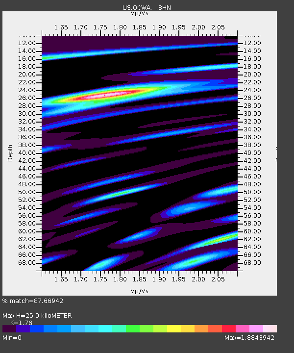
| Estimated Moho Depth: |
25.0 km |
| Estimated Crust Vp/Vs: |
1.76 |
| Assumed Crust Vp: |
6.134 km/s |
| Estimated Crust Vs: |
3.485 km/s |
| Estimated Crust Poisson's Ratio: |
0.26 |
|
| Radial Match: |
87.66942 % |
| Radial Bump: |
400 |
| Transverse Match: |
72.76603 % |
| Transverse Bump: |
400 |
| SOD ConfigId: |
110177 |
| Insert Time: |
2010-03-05 06:55:09.857 +0000 |
| GWidth: |
2.5 |
| Max Bumps: |
400 |
| Tol: |
0.001 |
|

Signal To Noise
| Channel | StoN | STA | LTA |
| US:OCWA: :BHN:20040908T11:11:36.634021Z | 1.3992184 | 1.380377E-7 | 9.865344E-8 |
| US:OCWA: :BHE:20040908T11:11:36.634021Z | 0.77949136 | 1.2865515E-7 | 1.6505011E-7 |
| US:OCWA: :BHZ:20040908T11:11:36.634021Z | 2.6350245 | 3.648391E-7 | 1.3845757E-7 |
| Arrivals |
| Ps | 3.2 SECOND |
| PpPs | 11 SECOND |
| PsPs/PpSs | 14 SECOND |


