You are here: Home > Network List > US - United States National Seismic Network Stations List
> Station OCWA Octopus Mountain, Washington, USA > Earthquake Result Viewer
OCWA Octopus Mountain, Washington, USA - Earthquake Result Viewer
| Earthquake location: |
Leeward Islands |
| Earthquake latitude/longitude: |
15.7/-61.7 |
| Earthquake time(UTC): |
2004/11/21 (326) 11:41:07 GMT |
| Earthquake Depth: |
14 km |
| Earthquake Magnitude: |
6.3 MB, 6.1 MS, 6.3 MW, 6.3 MW |
| Earthquake Catalog/Contributor: |
WHDF/NEIC |
|
| Network: |
US United States National Seismic Network |
| Station: |
OCWA Octopus Mountain, Washington, USA |
| Lat/Lon: |
47.75 N/124.18 W |
| Elevation: |
671 m |
|
| Distance: |
60.1 deg |
| Az: |
316.338 deg |
| Baz: |
99.783 deg |
| Ray Param: |
0.06175229 |
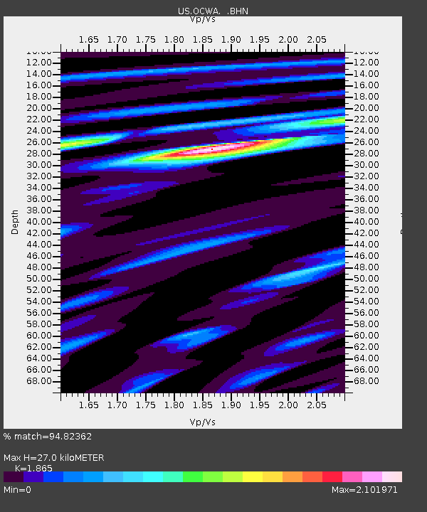
| Estimated Moho Depth: |
27.0 km |
| Estimated Crust Vp/Vs: |
1.87 |
| Assumed Crust Vp: |
6.134 km/s |
| Estimated Crust Vs: |
3.289 km/s |
| Estimated Crust Poisson's Ratio: |
0.30 |
|
| Radial Match: |
94.82362 % |
| Radial Bump: |
400 |
| Transverse Match: |
85.04993 % |
| Transverse Bump: |
400 |
| SOD ConfigId: |
110177 |
| Insert Time: |
2010-03-05 06:55:19.243 +0000 |
| GWidth: |
2.5 |
| Max Bumps: |
400 |
| Tol: |
0.001 |
|

Signal To Noise
| Channel | StoN | STA | LTA |
| US:OCWA: :BHN:20041121T11:50:43.262014Z | 0.4431888 | 3.1328668E-7 | 7.0689214E-7 |
| US:OCWA: :BHE:20041121T11:50:43.262014Z | 2.1941555 | 1.0778523E-6 | 4.912379E-7 |
| US:OCWA: :BHZ:20041121T11:50:43.262014Z | 3.8915136 | 1.7208822E-6 | 4.422141E-7 |
| Arrivals |
| Ps | 4.0 SECOND |
| PpPs | 12 SECOND |
| PsPs/PpSs | 16 SECOND |


