You are here: Home > Network List > US - United States National Seismic Network Stations List
> Station OCWA Octopus Mountain, Washington, USA > Earthquake Result Viewer
OCWA Octopus Mountain, Washington, USA - Earthquake Result Viewer
| Earthquake location: |
South Of Panama |
| Earthquake latitude/longitude: |
6.8/-82.4 |
| Earthquake time(UTC): |
2005/08/27 (239) 18:38:20 GMT |
| Earthquake Depth: |
10 km |
| Earthquake Magnitude: |
5.6 MB, 5.6 MS, 6.2 MW, 6.1 MW |
| Earthquake Catalog/Contributor: |
WHDF/NEIC |
|
| Network: |
US United States National Seismic Network |
| Station: |
OCWA Octopus Mountain, Washington, USA |
| Lat/Lon: |
47.75 N/124.18 W |
| Elevation: |
671 m |
|
| Distance: |
54.1 deg |
| Az: |
326.287 deg |
| Baz: |
125.244 deg |
| Ray Param: |
0.06568723 |
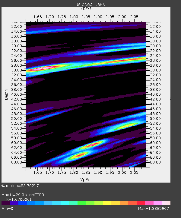
| Estimated Moho Depth: |
29.0 km |
| Estimated Crust Vp/Vs: |
1.67 |
| Assumed Crust Vp: |
6.134 km/s |
| Estimated Crust Vs: |
3.673 km/s |
| Estimated Crust Poisson's Ratio: |
0.22 |
|
| Radial Match: |
83.70217 % |
| Radial Bump: |
400 |
| Transverse Match: |
62.620865 % |
| Transverse Bump: |
400 |
| SOD ConfigId: |
2669 |
| Insert Time: |
2010-03-05 06:55:26.449 +0000 |
| GWidth: |
2.5 |
| Max Bumps: |
400 |
| Tol: |
0.001 |
|

Signal To Noise
| Channel | StoN | STA | LTA |
| US:OCWA: :BHN:20050827T18:47:14.458005Z | 1.6589556 | 3.4069205E-7 | 2.0536538E-7 |
| US:OCWA: :BHE:20050827T18:47:14.458005Z | 2.1340902 | 3.937233E-7 | 1.8449234E-7 |
| US:OCWA: :BHZ:20050827T18:47:14.458005Z | 6.3569474 | 8.526912E-7 | 1.3413532E-7 |
| Arrivals |
| Ps | 3.3 SECOND |
| PpPs | 12 SECOND |
| PsPs/PpSs | 15 SECOND |


