You are here: Home > Network List > US - United States National Seismic Network Stations List
> Station OCWA Octopus Mountain, Washington, USA > Earthquake Result Viewer
OCWA Octopus Mountain, Washington, USA - Earthquake Result Viewer

| Earthquake location: |
Northwest Of Kuril Islands |
| Earthquake latitude/longitude: |
47.8/146.2 |
| Earthquake time(UTC): |
2002/11/17 (321) 04:53:53 GMT |
| Earthquake Depth: |
459 km |
| Earthquake Magnitude: |
7.3 MW, 7.3 MW |
| Earthquake Catalog/Contributor: |
WHDF/NEIC |
|
| Network: |
US United States National Seismic Network |
| Station: |
OCWA Octopus Mountain, Washington, USA |
| Lat/Lon: |
47.75 N/124.18 W |
| Elevation: |
671 m |
|
| Distance: |
56.7 deg |
| Az: |
53.799 deg |
| Baz: |
306.313 deg |
| Ray Param: |
0.062152304 |
| Estimated Moho Depth: |
28.75 km |
| Estimated Crust Vp/Vs: |
1.78 |
| Assumed Crust Vp: |
6.134 km/s |
| Estimated Crust Vs: |
3.441 km/s |
| Estimated Crust Poisson's Ratio: |
0.27 |
|
| Radial Match: |
84.44186 % |
| Radial Bump: |
400 |
| Transverse Match: |
80.0855 % |
| Transverse Bump: |
400 |
| SOD ConfigId: |
4714 |
| Insert Time: |
2010-03-05 06:55:32.606 +0000 |
| GWidth: |
2.5 |
| Max Bumps: |
400 |
| Tol: |
0.001 |
|
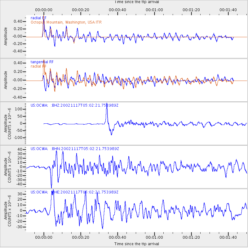
Signal To Noise
| Channel | StoN | STA | LTA |
| US:OCWA: :BHN:20021117T05:02:21.753989Z | 3.8752902 | 1.3751835E-5 | 3.5485946E-6 |
| US:OCWA: :BHE:20021117T05:02:21.753989Z | 6.9938927 | 1.3190348E-5 | 1.8859809E-6 |
| US:OCWA: :BHZ:20021117T05:02:21.753989Z | 19.459736 | 4.45985E-5 | 2.2918348E-6 |
| Arrivals |
| Ps | 3.8 SECOND |
| PpPs | 12 SECOND |
| PsPs/PpSs | 16 SECOND |


