You are here: Home > Network List > US - United States National Seismic Network Stations List
> Station OCWA Octopus Mountain, Washington, USA > Earthquake Result Viewer
OCWA Octopus Mountain, Washington, USA - Earthquake Result Viewer

| Earthquake location: |
Solomon Islands |
| Earthquake latitude/longitude: |
-10.5/160.8 |
| Earthquake time(UTC): |
2003/01/20 (020) 08:43:06 GMT |
| Earthquake Depth: |
33 km |
| Earthquake Magnitude: |
6.7 MB, 7.8 MS, 7.3 MW, 7.2 MW |
| Earthquake Catalog/Contributor: |
WHDF/NEIC |
|
| Network: |
US United States National Seismic Network |
| Station: |
OCWA Octopus Mountain, Washington, USA |
| Lat/Lon: |
47.75 N/124.18 W |
| Elevation: |
671 m |
|
| Distance: |
87.8 deg |
| Az: |
40.729 deg |
| Baz: |
251.97 deg |
| Ray Param: |
0.04298895 |
| Estimated Moho Depth: |
29.75 km |
| Estimated Crust Vp/Vs: |
1.65 |
| Assumed Crust Vp: |
6.134 km/s |
| Estimated Crust Vs: |
3.717 km/s |
| Estimated Crust Poisson's Ratio: |
0.21 |
|
| Radial Match: |
93.94745 % |
| Radial Bump: |
400 |
| Transverse Match: |
89.702194 % |
| Transverse Bump: |
400 |
| SOD ConfigId: |
110177 |
| Insert Time: |
2010-03-05 06:55:38.451 +0000 |
| GWidth: |
2.5 |
| Max Bumps: |
400 |
| Tol: |
0.001 |
|
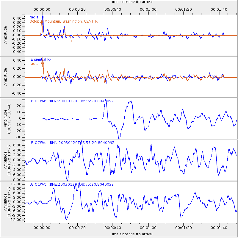
Signal To Noise
| Channel | StoN | STA | LTA |
| US:OCWA: :BHN:20030120T08:55:20.804009Z | 1.0833198 | 6.657987E-7 | 6.145911E-7 |
| US:OCWA: :BHE:20030120T08:55:20.804009Z | 1.4885402 | 7.7938614E-7 | 5.23591E-7 |
| US:OCWA: :BHZ:20030120T08:55:20.804009Z | 2.2870896 | 1.5996187E-6 | 6.994124E-7 |
| Arrivals |
| Ps | 3.2 SECOND |
| PpPs | 13 SECOND |
| PsPs/PpSs | 16 SECOND |


