You are here: Home > Network List > US - United States National Seismic Network Stations List
> Station KNB Kanab, Kane County, Utah, USA > Earthquake Result Viewer
KNB Kanab, Kane County, Utah, USA - Earthquake Result Viewer
| Earthquake location: |
Kuril Islands |
| Earthquake latitude/longitude: |
44.5/149.1 |
| Earthquake time(UTC): |
1995/11/24 (328) 17:24:12 GMT |
| Earthquake Depth: |
33 km |
| Earthquake Magnitude: |
6.1 MB, 6.3 MS, 6.1 UNKNOWN, 6.6 MW |
| Earthquake Catalog/Contributor: |
WHDF/NEIC |
|
| Network: |
US United States National Seismic Network |
| Station: |
KNB Kanab, Kane County, Utah, USA |
| Lat/Lon: |
37.02 N/112.82 W |
| Elevation: |
1715 m |
|
| Distance: |
70.2 deg |
| Az: |
57.37 deg |
| Baz: |
311.201 deg |
| Ray Param: |
0.055082455 |
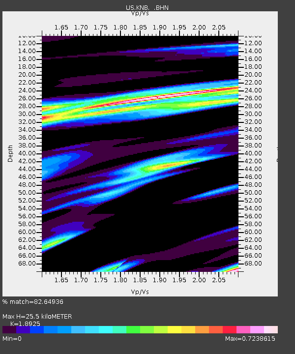
| Estimated Moho Depth: |
25.5 km |
| Estimated Crust Vp/Vs: |
1.89 |
| Assumed Crust Vp: |
6.194 km/s |
| Estimated Crust Vs: |
3.273 km/s |
| Estimated Crust Poisson's Ratio: |
0.31 |
|
| Radial Match: |
82.64936 % |
| Radial Bump: |
400 |
| Transverse Match: |
61.305134 % |
| Transverse Bump: |
400 |
| SOD ConfigId: |
110177 |
| Insert Time: |
2010-03-05 06:56:45.009 +0000 |
| GWidth: |
2.5 |
| Max Bumps: |
400 |
| Tol: |
0.001 |
|
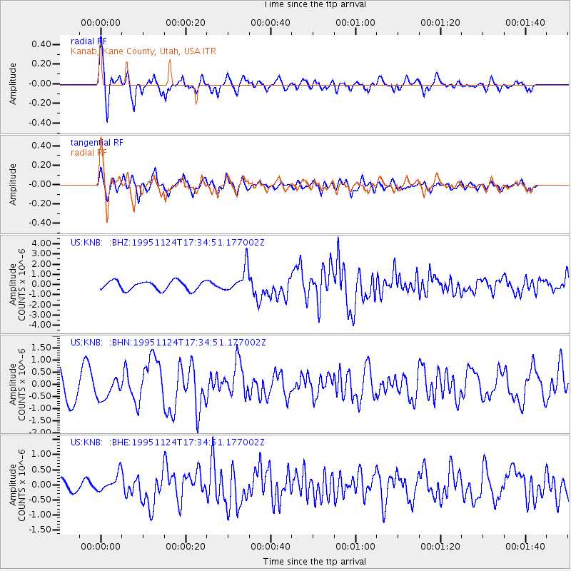
Signal To Noise
| Channel | StoN | STA | LTA |
| US:KNB: :BHN:19951124T17:34:51.177002Z | 0.72792625 | 4.2017405E-7 | 5.7722065E-7 |
| US:KNB: :BHE:19951124T17:34:51.177002Z | 0.9288135 | 2.9712444E-7 | 3.1989677E-7 |
| US:KNB: :BHZ:19951124T17:34:51.177002Z | 2.8420916 | 1.2548568E-6 | 4.415258E-7 |
| Arrivals |
| Ps | 3.8 SECOND |
| PpPs | 12 SECOND |
| PsPs/PpSs | 15 SECOND |


