
Station US KNB - Kanab, Kane County, Utah, USA
Network: US - United States National Seismic Network
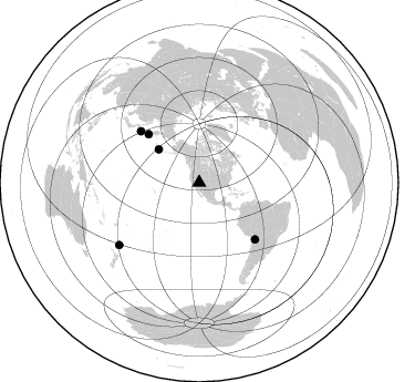
Nearby stations (2 deg radius)
| Station | Name | (Lat, Lon) | Start / End | Elevation |
| KNB | Kanab, Kane County, Utah, USA | (37.02, -112.82) | 1995-05-17 / 2499-01-01 | 1715 m |
| Crust2 Type: | MD,thin extended crust, 1.5 km seds. |
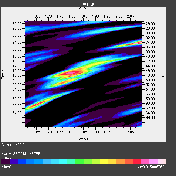
| Thickness Estimate: | 34 km |
| Thickness StdDev: | 10 km |
| Vp/Vs Estimate: | 2.10 |
| Vp/Vs StdDev: | 0.16 |
| Vs Estimate: | 2.953 km/s |
| Poisson's Ratio: | 0.35 |
| Peak Value: | 0.02 |
| Assumed Vp: | 6.194 km/s |
| Ps Weight: | 0.33333334 |
| PpPs Weight: | 0.33333334 |
| PsPs Weight: | 0.33333328 |
| Residual Complexity: | 0.885 |
| Nearby stations H: | +- |
| (2.0 deg) Vp/Vs: | +- |
2 with match > 90% ( 20.0 %) and 5 with match > 80% ( 50.0 %) out of 10.
Download stack as xyz text file.
Azimuth Distribution of Events:
Prior Results for this Station
| Study | Thickness | Vp/Vs | Vp | Vs | Poissons Ratio | Extra |
| EARS | 34 km | 2.10 | 6.194 km/s | 2.953 km/s | 0.35 | |
| Crust2.0 | 34 km | 1.78 | 6.194 km/s | 3.483 km/s | 0.27 | MD,thin extended crust, 1.5 km seds. |
| Global Maxima | 34 km | 2.10 | 6.194 km/s | 2.953 km/s | 0.35 | amp=0.015006759 |
| Local Maxima 1 | 47 km | 1.80 | 6.194 km/s | 3.446 km/s | 0.28 | amp=0.0129530355 |
| Local Maxima 2 | 60 km | 1.65 | 6.194 km/s | 3.743 km/s | 0.21 | amp=0.01242817 |
| Local Maxima 3 | 48 km | 1.80 | 6.194 km/s | 3.446 km/s | 0.28 | amp=0.008294339 |
| Local Maxima 4 | 42 km | 1.97 | 6.194 km/s | 3.152 km/s | 0.33 | amp=0.0069243214 |
| Predicted Arrivals for vertical incidence (zero ray parameter) | |
| Ps | 5.98 SECOND |
| PpPs | 16.88 SECOND |
| PsPs/PpSs | 22.86 SECOND |
Events Processed for this Station
Download zip of receiver functions as SAC
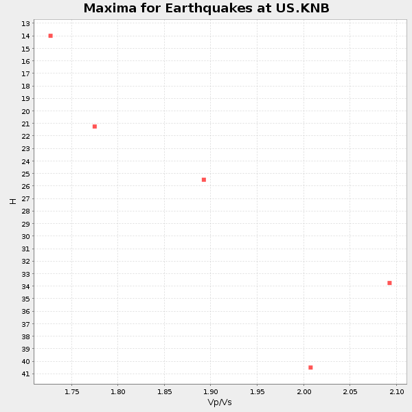
Plot maxima for each earthquake.
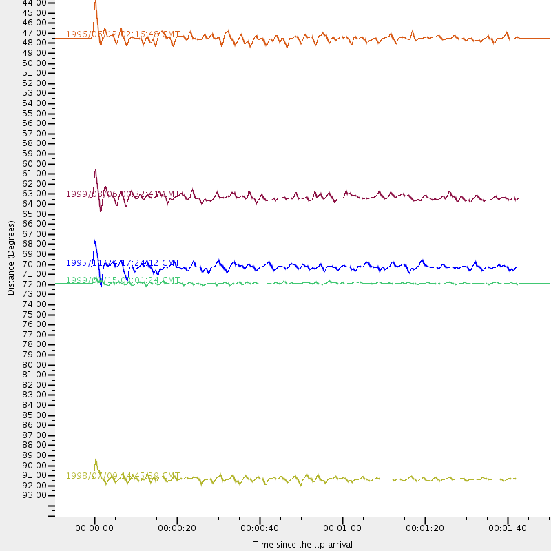
Events Used in the Stack
(5 events)| Radial Match | Distance | Baz | FERegion | Time | Lat/Lon | Depth | Magnitude |
| 93.85317 | 91.3 deg | 232.173 deg | Kermadec Islands, New Zealand | 1998/07/09 14:45:39 GMT | (-30.5, -179.0) | 130 km | 6.2 MB, 6.2 MS, 6.9 UNKNOWN, 6.4 ME |
| 92.77548 | 71.9 deg | 135.403 deg | Southern Bolivia | 1999/09/15 03:01:24 GMT | (-20.9, -67.3) | 218 km | 6.0 MB, 6.4 MW, 6.4 MW |
| 87.10828 | 63.3 deg | 313.68 deg | Kuril Islands | 1999/08/06 00:32:41 GMT | (49.9, 156.3) | 58 km | 5.5 MB, 5.5 MS, 5.9 MW, 5.8 MW |
| 84.81242 | 47.5 deg | 309.408 deg | Andreanof Islands, Aleutian Is. | 1996/06/12 02:16:48 GMT | (51.4, -178.2) | 33 km | 5.5 MB, 5.3 MS, 5.7 UNKNOWN, 5.6 ML |
| 82.64936 | 70.2 deg | 311.201 deg | Kuril Islands | 1995/11/24 17:24:12 GMT | (44.5, 149.1) | 33 km | 6.1 MB, 6.3 MS, 6.1 UNKNOWN, 6.6 MW |
Losers
(5 events)| Radial Match | Distance | Baz | FERegion | Time | Lat/Lon | Depth | Magnitude | Reason |
| 82.83687 | 97.0 deg | 269.082 deg | New Britain Region, P.N.G. | 1996/08/10 11:20:19 GMT | (-4.9, 152.1) | 33 km | 5.6 MB, 6.0 MS, 6.2 UNKNOWN, 6.1 MW | |
| 79.80976 | 89.6 deg | 254.986 deg | Santa Cruz Islands | 1996/09/01 06:45:41 GMT | (-11.8, 166.6) | 187 km | 5.5 MB, 5.9 UNKNOWN, 5.8 MW | |
| 75.303406 | 68.2 deg | 311.011 deg | Kuril Islands | 1999/05/08 19:44:35 GMT | (45.4, 151.6) | 63 km | 6.2 MB, 5.3 MS, 5.9 MW, 5.9 MW | |
| 73.62312 | 84.9 deg | 302.84 deg | Southeast Of Honshu, Japan | 1996/02/14 21:26:56 GMT | (29.2, 140.4) | 142 km | 5.9 MB | |
| 49.077896 | 82.3 deg | 239.795 deg | Fiji Islands Region | 1996/01/16 05:15:27 GMT | (-18.7, -177.5) | 334 km | 5.7 UNKNOWN, 5.4 MB |
