You are here: Home > Network List > US - United States National Seismic Network Stations List
> Station KNB Kanab, Kane County, Utah, USA > Earthquake Result Viewer
KNB Kanab, Kane County, Utah, USA - Earthquake Result Viewer
| Earthquake location: |
Andreanof Islands, Aleutian Is. |
| Earthquake latitude/longitude: |
51.4/-178.2 |
| Earthquake time(UTC): |
1996/06/12 (164) 02:16:48 GMT |
| Earthquake Depth: |
33 km |
| Earthquake Magnitude: |
5.5 MB, 5.3 MS, 5.7 UNKNOWN, 5.6 ML |
| Earthquake Catalog/Contributor: |
WHDF/NEIC |
|
| Network: |
US United States National Seismic Network |
| Station: |
KNB Kanab, Kane County, Utah, USA |
| Lat/Lon: |
37.02 N/112.82 W |
| Elevation: |
1715 m |
|
| Distance: |
47.5 deg |
| Az: |
80.982 deg |
| Baz: |
309.408 deg |
| Ray Param: |
0.069909334 |
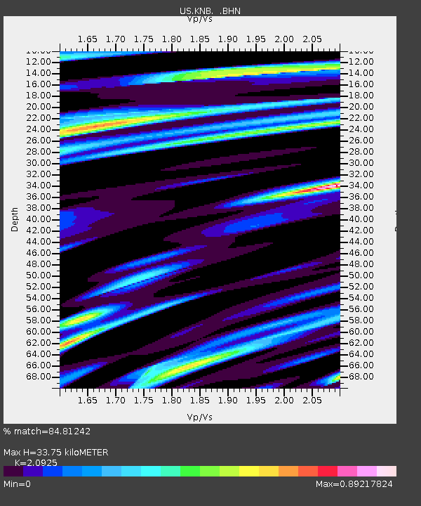
| Estimated Moho Depth: |
33.75 km |
| Estimated Crust Vp/Vs: |
2.09 |
| Assumed Crust Vp: |
6.194 km/s |
| Estimated Crust Vs: |
2.96 km/s |
| Estimated Crust Poisson's Ratio: |
0.35 |
|
| Radial Match: |
84.81242 % |
| Radial Bump: |
400 |
| Transverse Match: |
68.685936 % |
| Transverse Bump: |
400 |
| SOD ConfigId: |
110177 |
| Insert Time: |
2010-03-05 06:56:46.760 +0000 |
| GWidth: |
2.5 |
| Max Bumps: |
400 |
| Tol: |
0.001 |
|
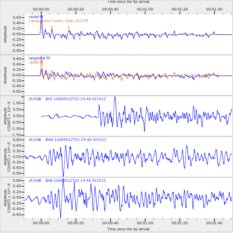
Signal To Noise
| Channel | StoN | STA | LTA |
| US:KNB: :BHN:19960612T02:24:49.42301Z | 2.6352208 | 1.5964285E-7 | 6.058045E-8 |
| US:KNB: :BHE:19960612T02:24:49.42301Z | 1.3561482 | 1.225694E-7 | 9.038054E-8 |
| US:KNB: :BHZ:19960612T02:24:49.42301Z | 4.08607 | 3.2291715E-7 | 7.902879E-8 |
| Arrivals |
| Ps | 6.2 SECOND |
| PpPs | 16 SECOND |
| PsPs/PpSs | 22 SECOND |


